Field Seminar
Banff, Canada
Saturday, 11 May 2024, 8:00 a.m.–3:00 p.m.
Time:
8:00am - 5:00pm
Fee:
$300 AAPG members
$350 Nonmembers
$200 Academic/AAPG Emeritus Members
$50 discount for workshop registrants
Fee Includes:
Transportation
Insurance
Field guide
Entrance fee to Banff National Park
Registration available during workshop registration
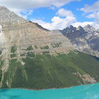
This field trip will focus on the structural geology of the foothills and Front Ranges of Banff.
Participants will be able to view excellent field examples of structures very similar to the producing oil and gas fields in the foothills to the west of Calgary and to learn about the complexities of sub-seismic-scale deformation.
The field trip starts with an introduction to the interaction between thrust front with foreland basins and the interaction of basement trends with thrust belt geometries and (conventional) hydrocarbon fields. During the 1-day trip participants will follow a dip transect from the undeformed foreland basin, the eastern edge of the foothills marked by the triangle zone, the Front Ranges boundary and end at the Main Ranges west of Banff.
Field Trip Itinerary
Depart from Calgary – 8:00 a.m.
Stop 1: Cochrane Retreat Road Overlook
Trip overview and introduction; safety and logistics comments; interaction of thrust front with foreland basin; interaction of basement trends with thrust belt geometry and (conventional) hydrocarbon field distribution; appreciation of scale for subsurface play fairway.
Stop 2: Scott Lake
Stop 3: The Stony Nakoda Tim’s
Classic stop, with historical importance for understanding the thrust belt and thrust geometry. Part 1 of displacement gradient on a large thrust. Most importantly, toilet stop after all the Tim’s coffee and driving. Review of Mt Yamnuska from a different perspective; preview of drive through McConnell damage zone and change in HW stratigraphy..
Stop 4: Lac des Arcs
Imbricate thrust sheets in the Front Ranges and Banff Formation.
Stop 5: Canmore T-junction
Observe complexities of sub-seismic-scale deformation in mechanically layered rocks in the footwall of a large thrust
Stop 6: Canmore strike view of the Rundle thrust
Exposed strike view analogous to a cut-away of a giant conventional Foothills hydrocarbon field such as Turner Valley. Cross faults within the thrust sheet offset potential reservoir units at sub-seismic scale. Cross faults are arguably part of a regional trend associated with deeper, basement-rooted NE-SW structures.
Stop 7: Mt Norquay Overlook
Stop 8: Bow Falls
Fracture systems in the Vega Siltstone Mbr of the Triassic Sulphur Mtn Fm. This outcrop of Vega Member siltstone of the Sulphur Mtn Fm is considered equivalent to upper Montney Fm. We will focus on the outcrop adjacent to the steps up to the Falls overlook.
American Association of Petroleum Geologists (AAPG)
Added on 16 February, 2024