

Imagine scrolling through hundreds of seismic time slices, hunting for subtle features – meandering channels, fault terminations, karst collapse structures, or reef margins. The patterns begin to blur. Manual interpretation is tedious and prone to inconsistency, yet traditional machine learning demands hundreds of hand- labeled examples before it can help. For most projects, we simply don’t have the time or the training data.
What if you could borrow the intelligence of a model already trained over a million images – one that understands edges, boundaries, and objects without ever seeing your specific geology?
In 2023, Meta AI released a model called “Segment Anything Model.” It is what researchers call a “foundation model.” Unlike traditional AI models, which require training on thousands of labeled seismic examples, SAM was trained on more than a million natural images. It understands the concept of an edge or boundary for any object, no matter whether it’s looking at a cat, a dog, a house, or a seismic channel. Researchers call this “zero-shot generalization” meaning the model can identify features it has never seen before. For a geologist, this can drastically speed up your workflow. Instead of spending days training a specific neural network on each survey, we can utilize the power of a pre-trained tool like SAM to act as a digital guide that already understands an interpreter’s instinct for finding boundaries. This capability is now available to geologists via several software tools and can be adapted to any interpretation challenge where boundaries matter and labels are scarce.
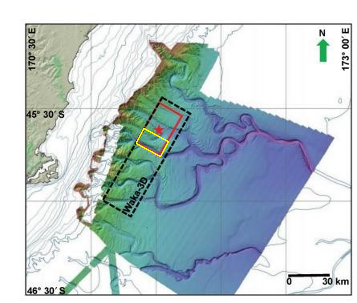
The Study Area
To illustrate the potential, we tested SAM on turbidite channels in the Canterbury Basin offshore New Zealand (figure1), a geologically complex area where traditional methods struggle. But the principles apply far more broadly: anywhere you need to segment, extract, or track geological features efficiently. This area is a playground for paleocanyons and deep water turbidite systems, characterized by complex, amalgamated channel elements. It lies at the transition between the continental slope and continental rise. These turbidites are of Cretaceous to Tertiary age and were deposited during a single transgressive regressive cycle.
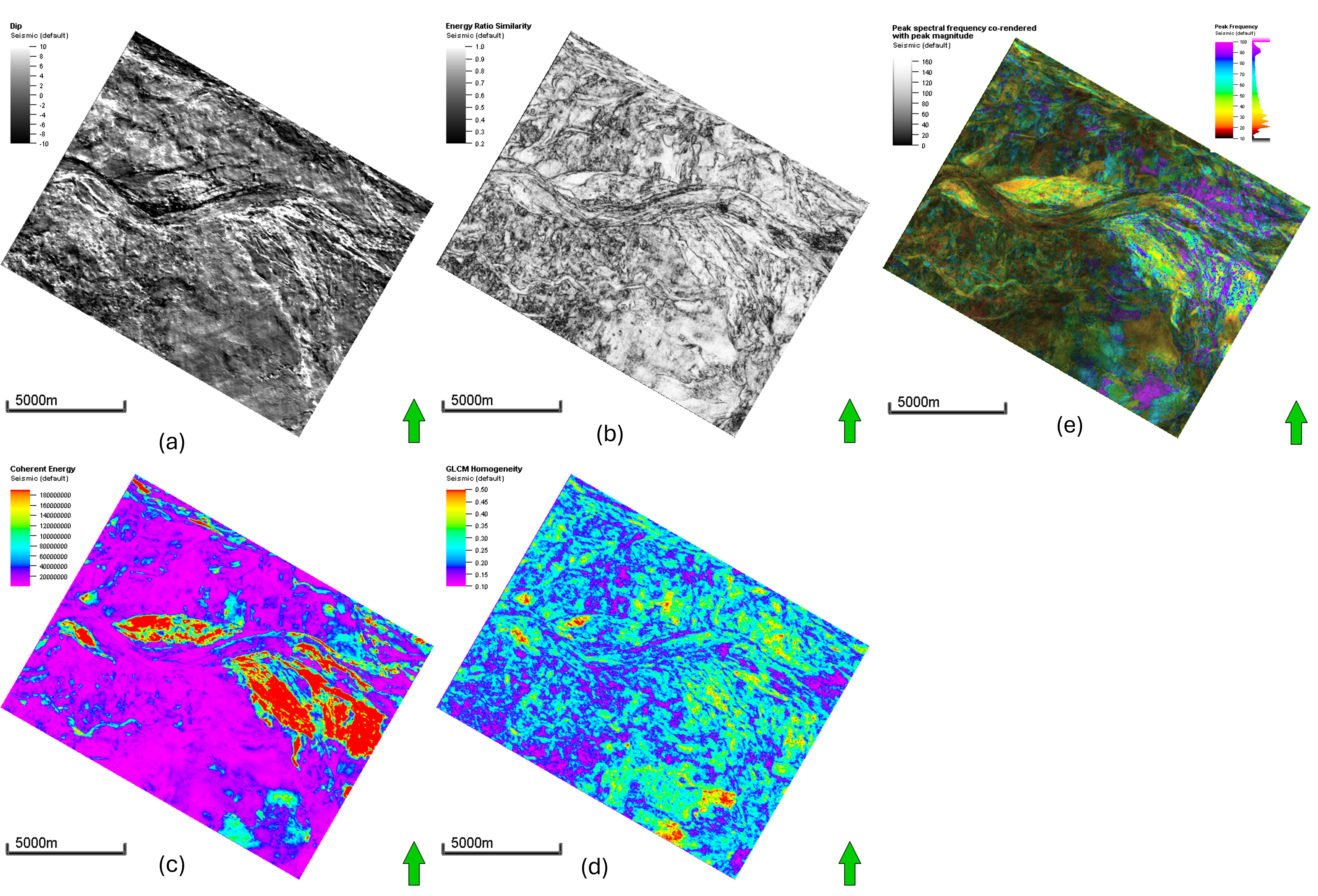
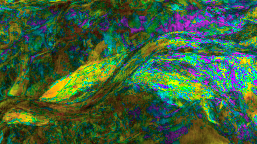
Attributes
Seismic attributes are quantitative measurements derived from seismic data that help us highlight specific geological features or rock properties that may not be obvious in the raw amplitude data. We calculated the dip attribute to measure dipping structures, energy ratio and coherent energy attributes to map channel edges, GLCM homogeneity to provide insight into internal channel architecture, and peak magnitude and frequency to highlight thin facies present in the channel system as shown in figure 2.
Mask and Logits, SOM with SAM
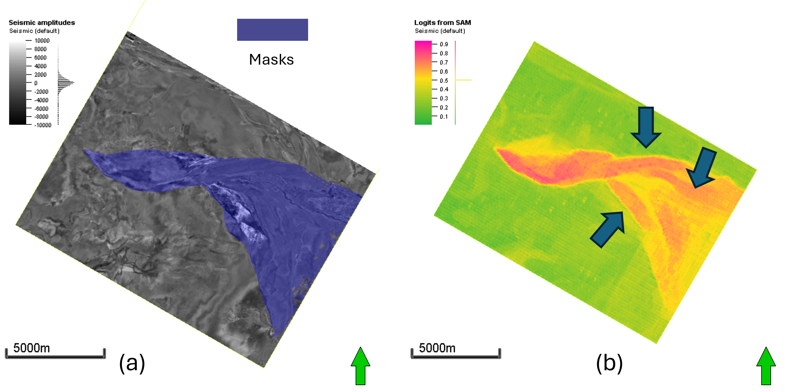
We used SAM to generate binary masks and logits of the channels on time slices (figure 3). Masks are the binary (0s and 1s) while logits are like an important map, showing where the AI model is most confident a channel exists. We treated this like another seismic attribute.
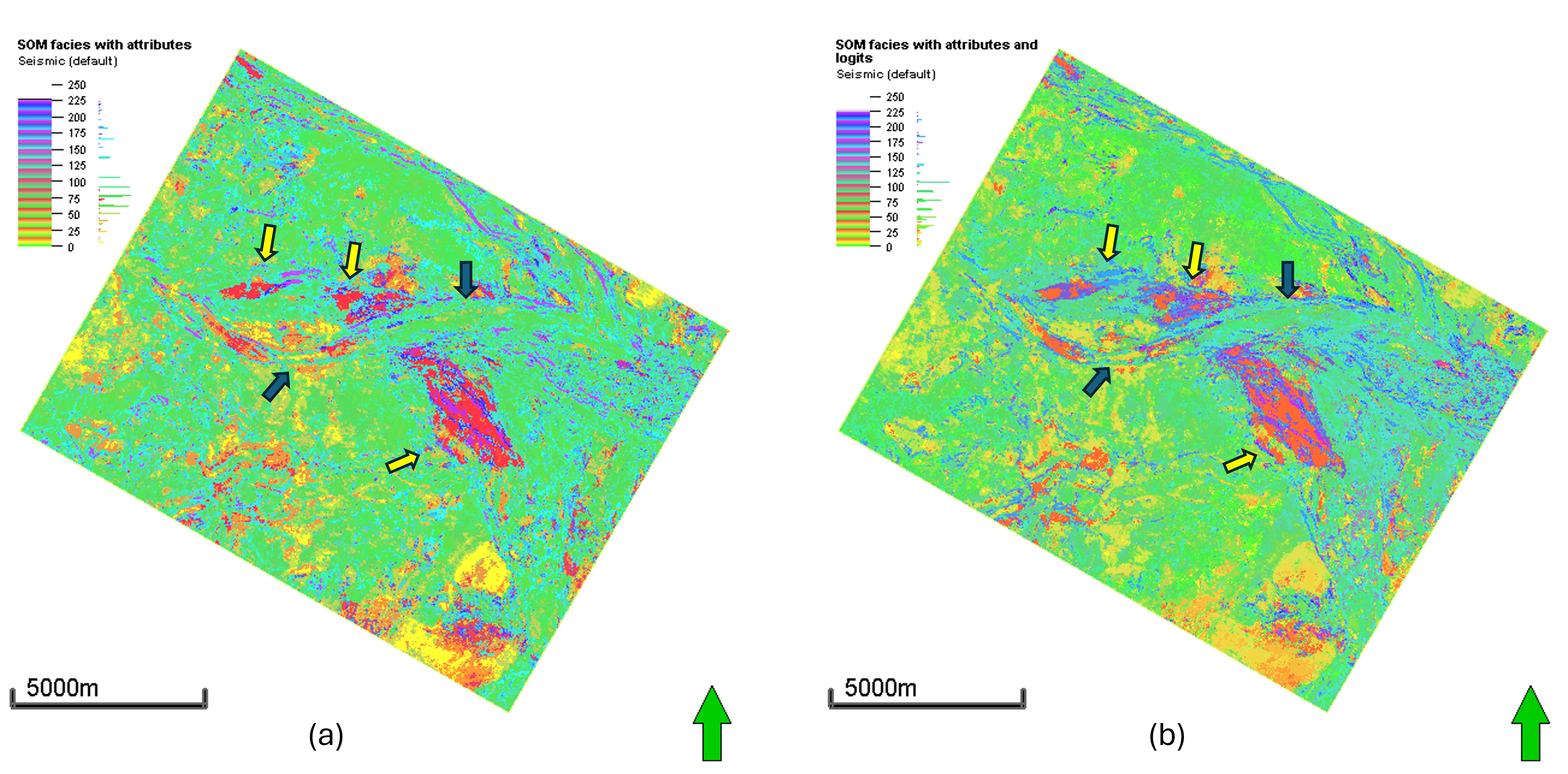
To see if AI could truly help, we combined the SAM with the classic unsupervised machine learning tool, the Self-organizing map (SOM). SOM acts as a clustering algorithm that organizes seismic attributes – edge detection, energy, texture – grouping similar data points together. All the facies are represented by color shade and it gives representation of geological facies present in the depositional system. Being unsupervised, SOM tries to map for every single variation in the seismic signal, which often leads to noisy, fragmented patterns. By bridging SAM with SOM, which essentially gives it a set of guide rails, we can focus more on the channel structures.
Better Boundaries, Better Geology!
Comparing the two approaches (figure 4) showed a noticeable difference in how we could clearly see geology. Adding the logits as an attribute helped mark the channel boundaries more efficiently. It also highlighted the separation between potential sand channels from surrounding mud-filled channels. The addition of logits essentially helped the clustering tools to put more focus on the channel structures instead of side details. This also improved our ability to see the internal architecture and facies patterns.
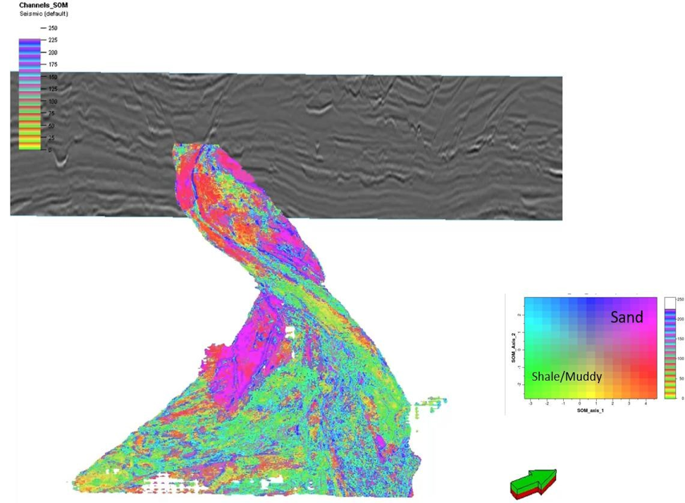
Besides improved clustering, the masks from SAM allowed us to isolate the channels from the rest of the seismic volume. These masks facilitate extracting channel features across different time slices, which supports consistent tracking of channel evolution as shown in figure 5. We can use these extracted features to build geobodies for the reservoir.
Finally, these masks can also serve as training labels in supervised machine learning workflows. This creates an efficient workflow: SAM helps interpret faster, and those interpretations can train future models specific to your geology.
Is This for Everyone?
The question we get most from the geoscience community is, “How hard is this to actually do ?”
Luckily, these tools are becoming much more accessible. SAM is open source and freely available to the public and while we used Python to run the model, and it is designed to be used as a “point and click” tool. You simply click on a feature you recognize as a channel, and the model instantly “snaps” to the boundaries.
This approach is a major leap forward. What used to take days of tediously manual picking can now be reduced to a few hours of interactive work. It fits well into the early stages of an interpretation project, allowing you to quickly screen a basin or build a preliminary reservoir modeling. By letting the AI handle the repetitive work, the interpreter can spend more time on the “why” of the geology.
Key Takeaway
For decades, we have relied on our own eyes to find the patterns in increasingly massive seismic datasets. By borrowing foundation models from a big world of AI, we are not just automating the tasks, we are assisting the interpreters in getting their work done efficiently while increasing their ability to see deeper insights. The future of seismic interpretation isn’t about handing the keys over to a “black box” that spits out an answer without context. Instead, it’s a partnership where the geologist provides the expertise and the AI provides the precision.
For the modern seismic explorer, the primary advantage of this approach is the elimination of bottleneck labeling. Because these foundation models are pretrained on massive datasets you no longer need hundreds of hand-drawn examples to get started. By using SAM-derived logits as an extra attribute, we can significantly enhance unsupervised clustering, leading to sharper boundaries and more confident reservoir characterization. SAM masks enable efficient extracting of facies along channels and making geobodies. Ultimately, this isn’t about replacing the interpreter – it is about turning “”fuzzy” seismic features into clear, actionable targets.