
Geophysics for the energy industry, especially marine seismic, continues to develop and advance on multiple fronts. The first involves new technology and techniques. The second reflects ongoing improvement – in signal capture, in inversion methods, in processing and imaging.
And the third is what gets the most attention now, and generates most of today’s speculation: the role artificial intelligence and machine learning will play in the geophysical future.
“There are some new ideas and technology, but we see traditional ways that have made improvement, also,” said Hua-Wei Zhou, professor of geophysics at the University of Houston.
Zhou listed four areas on which non-geophysicists might want to keep an eye: multisource seismic, more sensitive and durable receivers, a broader spectrum of signals and ocean-bottom seismic using nodes.
OBN Seismic
Surprisingly, one of the technologies with the biggest impact has been around for many years. Seismic nodes now show up everywhere, from ocean surveys to land applications, from 4-D monitoring to carbon capture, utilization and storage.
These nodes are self-contained sensor units or geophones with their own power source and data storage. Deployed in large numbers without cable connections, nodes can provide very high-density and high-definition surveys for subsurface imaging, reservoir monitoring and other uses.
Contemporary ocean-bottom node seismic dates back to the 1990s. As their cost declined and their efficiency improved, nodes were used in greater numbers and in more and more projects.
Once, a typical very-high-definition offshore survey might have employed node spacing at 50 meters-by-50 meters. But no longer, as spacing has tightened dramatically.
“To me, it’s mind-boggling. I’ve heard of 10-meter spacing in field OBN deployment. To me, that’s crazy,” Zhou said.
A CO2-injection assessment land survey in a one-square-kilometer area in Canada utilized almost 20,000 nodes, mostly deployed in a 7.5-by-7.5-meter carpet grid, with some at 3.75-meter spacing, and captured more than 250 million traces.
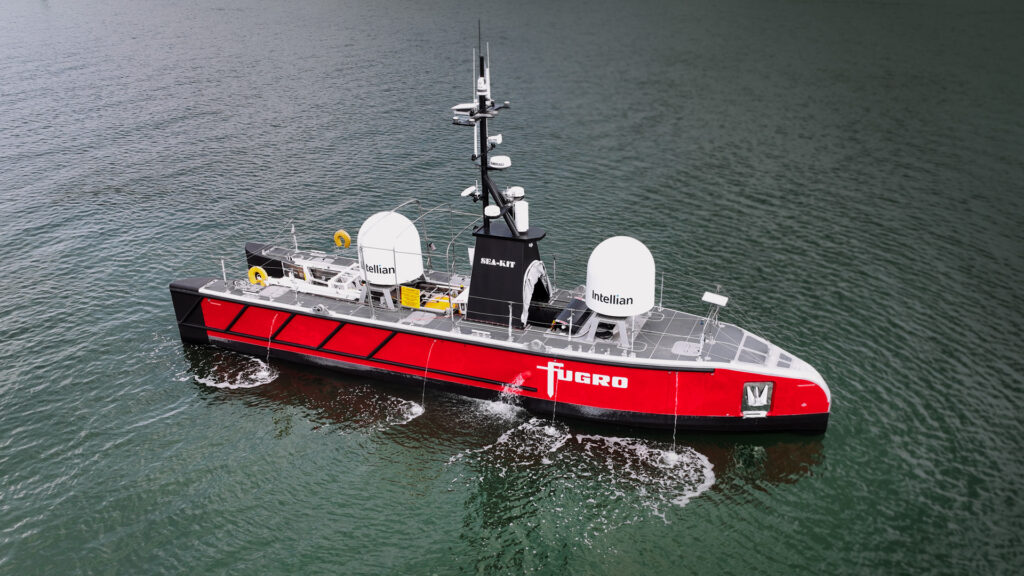
AI and sonar tools are boosting seabed characterization, vital for fixed offshore infrastructure, and the industry has increased use of unmanned vessels to acquire subsea data.
Engineering and geo-data firm Fugro offers geotechnical, survey and subsea services. Company experts identified several areas where new technologies have enhanced seafloor capabilities:
- AI-powered seabed feature recognition:
“Artificial Intelligence is revolutionizing interpretation workflows by automating the identification of seabed features, reducing turnaround times and enhancing data richness, especially when paired with structured data-tagging and digitized data flows,” said Alexis Spencer, Fugro digitalization and geo-data manager.
- High-resolution sensors
“The deployment of advanced, high-resolution sensor technologies, such as eBOSS (EdgeTech Buried Object Sonar System) and HiSAS (High-resolution Interferometric Synthetic Aperture Sonar), is significantly improving the detection and visualization of seafloor and sub-seafloor features.
“These systems contribute to enhanced accuracy in marine site characterization by providing clearer and more detailed imagery of underwater structures,” noted Melanie Barth, principal adviser for geo-data digitalization for Fugro.
- Autonomous and remote operations
“The use of USVs (uncrewed surface vessels) and remote platforms is expanding, allowing for safer, more efficient data acquisition with reduced environmental footprint,” said Hannes Swiegers, Fugro’s regional business line director of marine asset integrity for the Middle East and India.
AI and ML
Geophysical companies now describe ultra-high resolution and extremely-high resolution capabilities, primarily for near-subsurface use. Those surveys mainly rely on fast sampling rates and high-frequency acoustic sources. Exploration geophysics, by contrast, has increasingly moved toward broadband capture for a wider range of frequencies. A broad spectrum facilitates both structure definition and the imaging of smaller geological features.
“Low-frequency noise is hard to remove, but low-frequency signals are very helpful for better imaging with higher resolution,” Zhou noted.
Key to understanding results is answering the question, “How much is error?”
“Imaging of most targets we’re after – a pinch-out, a fault, a gas cap – the imagery has not only what you’re looking for but also other things, including artifacts and position errors,” Zhou observed.
“Resolution is just one angle to look at image quality. There are other angles in QC,” he said. “I’ve been pushing for more measurable elements of image fidelity, such as how to quantify image artifact and position error.”
For Zhou, this is where machine learning and AI begin to enter the picture. Based on thousands or millions of iterations and occurrences, they can help identify anomalies and correlations. But they still fall short in comprehending why a specific anomaly or correlation exists.
Geophysics has long drawn on outside help. Even in much earlier times, geoscientists were relying on augmented or assisted interpretation, Zhou observed. Geophysics incorporates many developments from outside petroleum, including medical imaging.
“We often borrow ideas from other disciplines and apply them to geoscience,” Zhou noted.
He said machine learning now has been introduced into geophysics for efficiency, for assistance in handling enormous volumes of data and for an exponential increase in outcomes considered.
“But to scientists, we’re always saying, ‘How can we improve quality?’ Not just, ‘How can we improve efficiency?,’” he said.
The most familiar type of AI for the general public is a generative pre-trained transformer (GPT). It gathers information, answers questions, generates writing and other output and has a high “Wow Factor.” But it’s probably a less meaningful type of AI for geophysics, Zhou said.
“There are lots of (types of) AIs. One of the AIs is like ChatGPT. They are using all the learning they’ve seen. It’s a searching tool,” he said.
The other type of AI, which assists human intelligence, is more relevant, Zhou believes. AI and machine learning tools that augment and support the efforts of the professional geoscientist will have greater value in the long run.
“I think the question for geoscientists, or whatever you are, is, ‘How do you adapt those tools for your area, for your problem?,’” he said.
In professional fields like geophysics, AI and machine learning today seem like a not-too-discerning and not-always-reliable assistant. Some scientists envision a future when those tools will improve to become more like a collaborator.
Looking ahead 5-10 years, “for interpretation, I think most people will be relying a lot on machine learning,” Zhou said.
“Initially, machine learning was more about efficiency. It may be, under certain other conditions, something beyond, something more like deduction of reasons behind correlations,” he said.
In the future, Zhou predicted, AI and machine learning tools “will bring some more significant insight into what’s going on. But they have to be supervised by a human being – an expert.”