The city of St. George, nestled in the southwestern-most corner of Utah, was founded in 1861 by Mormon settlers. The region was nicknamed “Utah’s Dixie” because they believed the climate of hot summers and mild winters was suitable for raising cotton. Mormon pioneer leader and church president Brigham Young maintained a winter home there. By the Great Depression years of the 1930s, the population of St. George had grown from fewer than 1,200 to more than 2,400 – mostly struggling farmers. Since 2000, St. George and the surrounding metropolitan area has seen massive growth, a population now of more than 200,000, as retirees from northern Utah and other states have flocked there to enjoy southern Utah’s scenic beauty and nearly snow-free weather. Representing the northeastern-most part of the Mohave Desert, the landscape around St. George is now one of lush golf courses, rows of condominiums and sprawling, affluent housing developments.
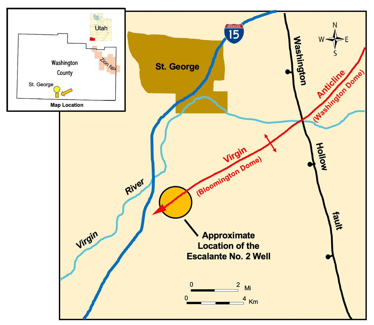
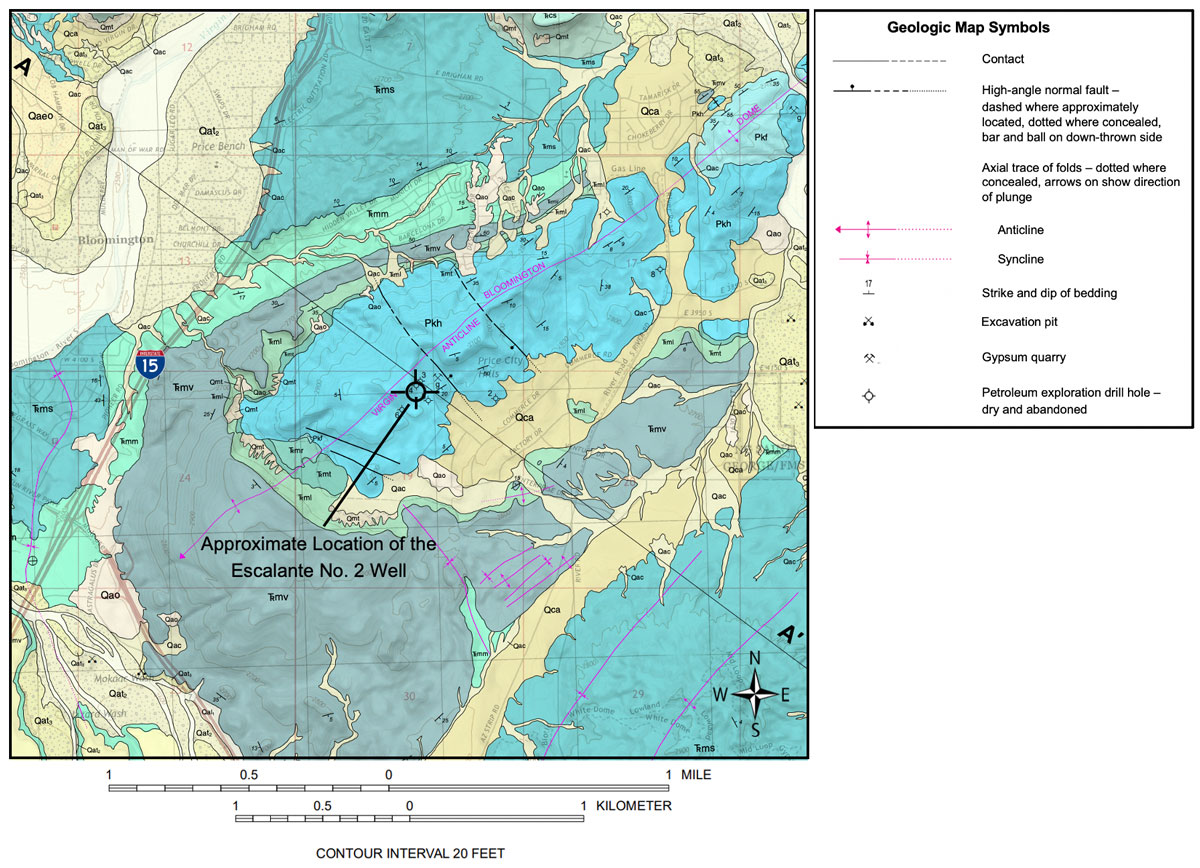
One such community, about 5 miles south of downtown St. George, is Hidden Valley Park. It includes a quiet street of relatively new large homes on East Barcelona Drive. The people living there are likely oblivious to an event that occurred 90 years ago just over the ridge behind their backyards when a wildcat well exploring for oil, the Escalante No. 2 (NW1/4NE1/4 section 19, T. 43 S., R. 15 W., Washington County; API No. 43-053-20534), exploded during drilling operations, killing 10 and injuring dozens of curious townsfolk from St. George.
They had come to witness the “shooting” – better known now as “frac’ing” – of the well: the detonation of a massive dynamite charge downhole in the hope for an oil gusher during the dark days of the Depression.
This disaster was not the first in Utah for the energy extraction industry. On May 1, 1900, a huge explosion occurred in the Winter Quarters coal mine near the town of Scofield on the Wasatch Plateau in east-central Utah. More than 200 miners were killed – the worst mining accident in American history to that point.
The St. George well blast was also not the first public spectacle in the United States resulting in the deaths of people who had come to watch an event presumed to be safe and perhaps history-making. On Sept. 15, 1896, an audience estimated at more than 40,000 attended a railroad publicity stunt in central Texas, where two steam locomotives were purposely crashed head-on into each other at high speed. Shortly after the collision, as spectators moved in for a closer look at the wreckage, the two boilers exploded, raining down debris on the crowd, killing two and injuring several others.
For many, until now, the 1935 Escalante No. 2 well catastrophe has remained an obscure event in Utah’s history, as well as in the chronicles of drilling for hydrocarbons in the United States. Questions about the Escalante No. 2 well might arise from petroleum geologists, oil history buffs, those who now call St. George home, or the many visitors to region:

What geology brought oil explorers to this then fairly remote part of Utah?
Are (or were) there any oil seeps or oil fields in the region?
Why did the operator choose the drill site (the trap, reservoir, oil shows in any previous wells, access)?
Were the operators honest in seeking local investors and support from the local citizens?
How was sending down and discharging a large quantity of dynamite in the wellbore going to result in oil production, and was it a new technique?
Finally, what motivated the operator to allow a large group of spectators on site to watch the outcome?
However those questions are answered, two outcomes are known for certain: dreams of a Texas-sized oil boom in the area were dashed, and many lives were shattered forever.
Geologic Setting
Southwestern Utah lies in the transition zone between two major physiographic provinces – the Colorado Plateau to the east and the Basin and Range to the west. The region has structural characteristics of both and includes the leading edge of the Early Cretaceous- Eocene (about 120 to 40 million years ago) Sevier orogenic thrust belt. This orogenic event produced associated local detachments in front, a postulated basal detachment, and large folds, which are cut by younger normal faults. Episodic uplift of southwestern Utah began about 70 million years ago along with extensive erosion; however, about 17 million years ago crustal extension created the Basin and Range Province west from the present-day flat lying strata of the Colorado Plateau Province. This extension overprints Sevier structures and is represented by north- to northwest-striking, down-to-the west normal faults in the transition zone between the two physiographic provinces. The Virgin River, which flows through the St. George area as part of the Colorado River drainage basin, began to rapidly downcut over the past 5.5 million years creating Zion Canyon and countless other erosive landforms throughout southwestern Utah.
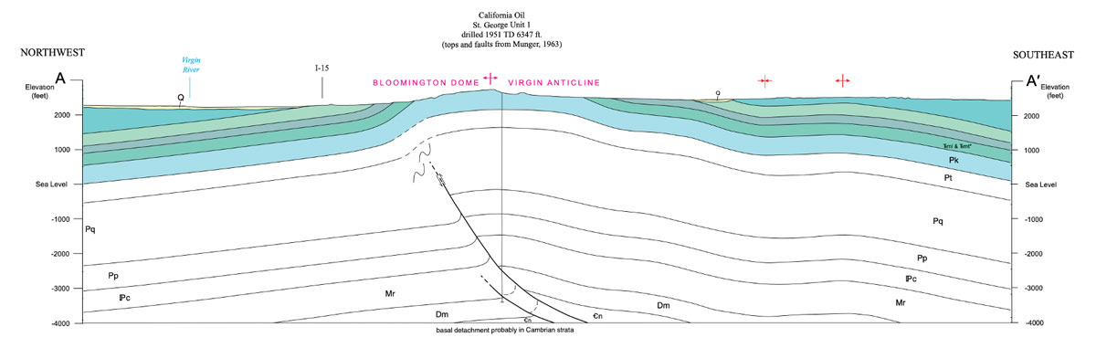
The dominant structural feature in the St. George region is the 30-mile-long, northeast-southwest-trending, doubly plunging Virgin anticline. This well-exposed, generally symmetrical fold is a textbook example of an anticline that geology students from all over come to view and study. Three dome-like subsidiary structures are found along its axis, from northeast to southwest these are the Harrisburg, Washington and Bloomington domes. Exposed in the cores of these domes is the Lower Permian Kaibab Limestone – the same formation that forms the rim of the Grand Canyon. The flanks consist of the unconformably overlying Lower Triassic Moenkopi Formation.
Bloomington dome is five miles south of St. George and is the largest of the three subsidiary structures at about 6-miles long and 2-miles wide at its widest point. It is asymmetrical, having the northwestern flank dipping 40 to 70 degrees and the southeastern flank dipping less than 20 degrees. On the axis are additional lesser but distinct, localized or subordinate domes. A small graben formed by northwest-southeast-trending faults is mapped on the crest of Bloomington dome. The 6,347-foot-deep St. George Unit 1, drilled in 1951, revealed the presence of two “blind” faults with about 900 feet of repeated section (Mississippian and Devonian) in the core of the fold interpreted as backthrusts. The vergence is opposite the regional southeast-directed Sevier-age thrusting.
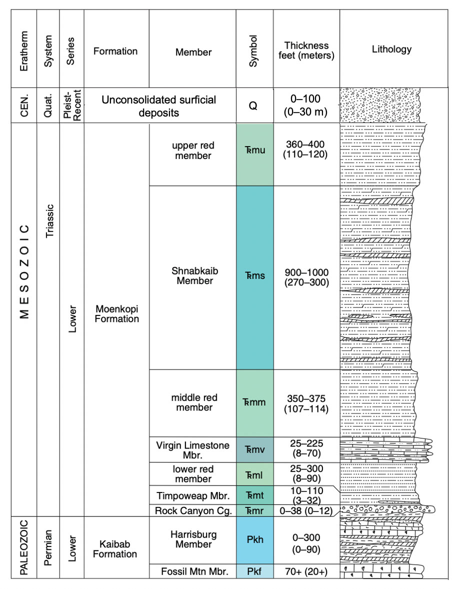
About 370 feet of Kaibab Limestone is exposed on the crest of Bloomington dome. It consists of relatively resistant gray, thin-bedded to massive limestone, with subordinate shale and sandstone; chert is common throughout with gypsum in the Harrisburg Member overlying the brachiopod-rich Fossil Mountain Member. The Kaibab was deposited in warm shallow marine and coastal sabkha environments.
The Moenkopi Formation is exposed on the flanks of Bloomington dome and is separated from the underlying Kaibab Limestone by the TR-1 unconformity. The Moenkopi varies in thickness from 1,800 to 2,400 feet and includes up to seven members. The lower, middle and upper red members consist of red to reddish-brown siltstone and mudstone representing deposition in a tidal flat environment; these members form strike valleys around the dome. Beneath the upper red member, the Shnabkaib Member consists of pale-red and reddish-brown layers of slope-forming mudstone and siltstone and ledgy slopes of white gypsum, which together have a bacon-striped appearance. In the lower part of the Moenkopi section, the Timpoweap and Virgin Limestone Members are yellowish to earthy ledges of fossiliferous limestone representing a shallow marine environment. The thin to absent, basal Rock Canyon Conglomerate Member was deposited as river sediments into incised paleovalleys.
Hydrocarbons in the Region
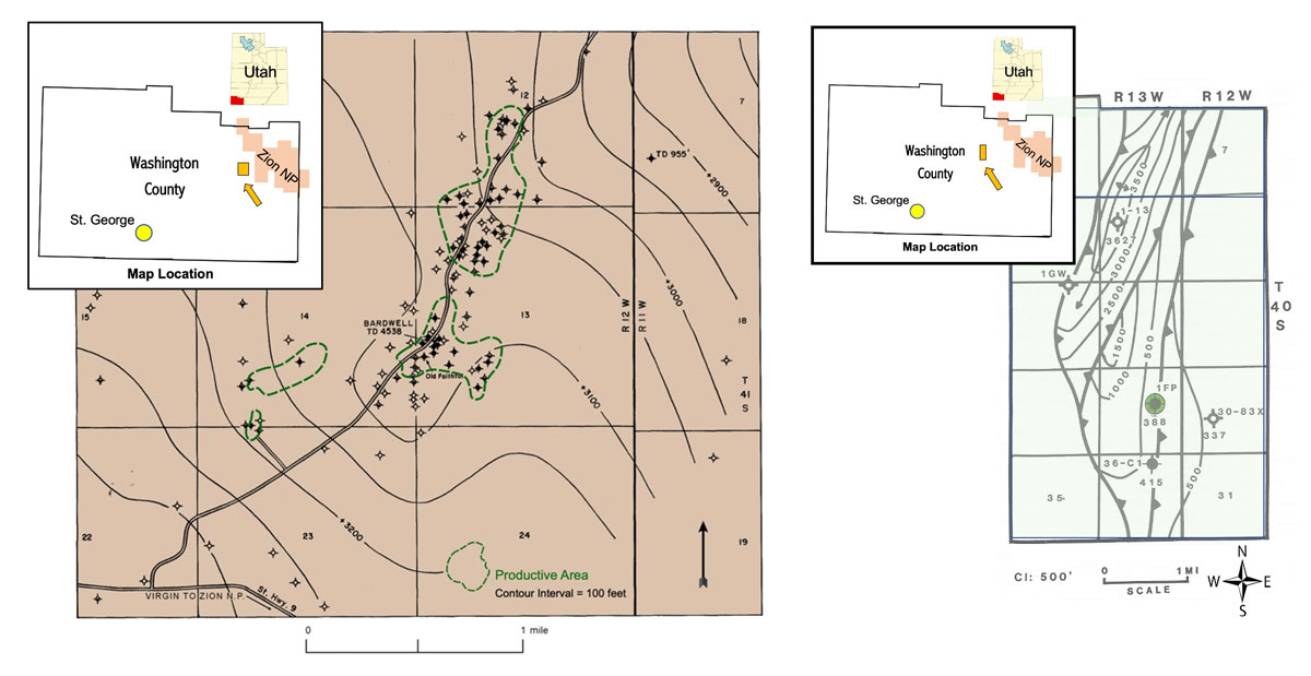
More than 170 wells have been drilled for oil and gas in Washington County. The result has been the discovery of two non-commercial oil fields, Virgin and Anderson Junction, both long abandoned. The rest ofthe wells in the county were unsuccessful dry holes that targeted areas with natural oil seeps near Virgin field and surface structures, such as those along the Virgin anticline.
Oil seeps led to the 1907 discovery of Virgin field, 3 miles west of Zion National Park. The reservoir was the Timpoweap Member of the Moenkopi Formation trapped by permeability barriers and fractures in carbonates on a structural nose, with some drainage into synclinal pockets along the flanks. The majority of the wells drilled in Washington County were located in Virgin field itself. Wells ranged in depth from about 400 to 750 feet. Total cumulative production was only about 2,000 barrels of oil before the field was finally abandoned in 1963.
Anderson Junction field was discovered in 1968 about 8 miles west-northwest of Virgin field. The reservoir is the Pennsylvanian Callville Limestone consisting of cherty limestone and dolomite. The trap is a small fault wedge, associated with the massive north-south-trending Hurricane fault, which was identified by well control and surface mapping. There was only one productive well in the field. It produced a total of 2,733 barrels of oil from a depth of about 4,100 feet. The field was abandoned due to poor economics; however, Anderson Junction proved that oil had been generated from Paleozoic source rocks in the region.
The Arrowhead Petroleum Corporation
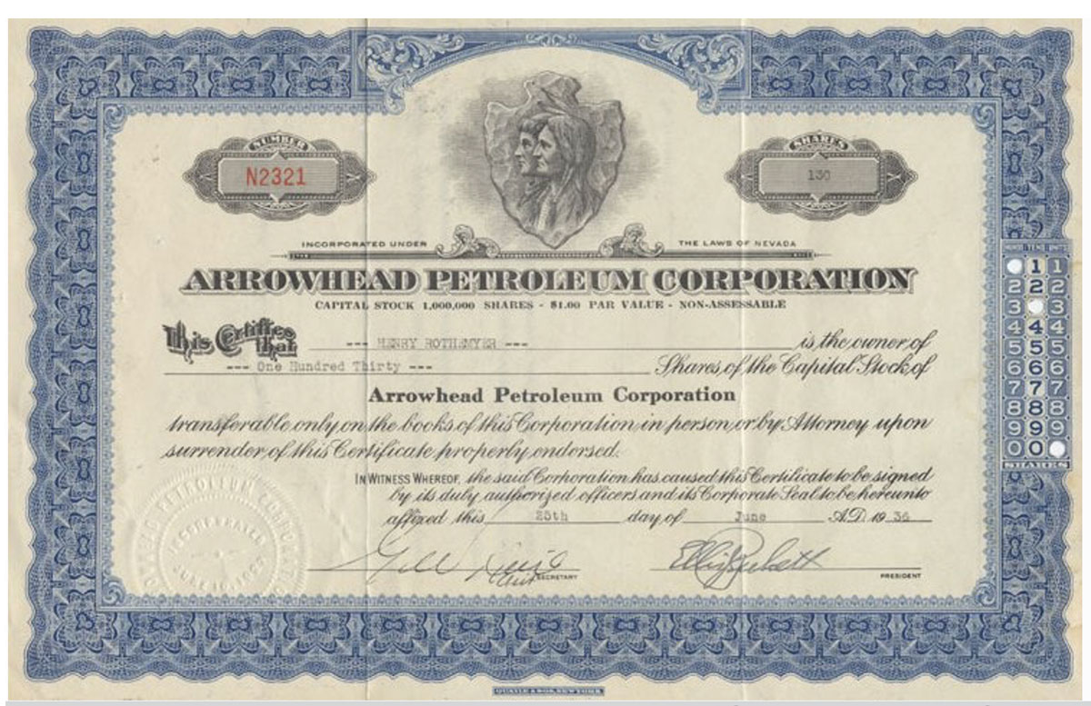
The operator of the Escalante No. 2 well was Arrowhead Petroleum Corporation, incorporated on June 10, 1927, in Nevada. The Board of Directors was composed of well-known businessmen from southern Utah and one from Salt Lake City – Fred C. Dern, brother of then Utah Gov. George Dern (Gov. Dern was the grandfather of actor Bruce Dern and great grandfather of actress Laura Dern.) These men were held in high esteem for their integrity and business sense. With discovery of oil at Virgin field, the anticlinal theory of oil and gas accumulations that developed in the late 1800s, and relatively new major oil discoveries on surface anticlines in Wyoming, they truly believed Washington County held huge promise too.
Arrowhead acquired lands over Bloomington dome and other structures near St. George, and garnered much support from the public and local newspapers for their efforts. Investment in the company was also encouraged by the St. George Chamber of Commerce, which held promotional public meetings and organized field trips to well sites. The State of Nevada authorized the company to issue one million shares of stock at $1.00 per share with a unique plan to initially market half of the issue. Out of each dollar paid in the sale of stock, 30 cents was to be deposited in a well-known bank to the credit of the stock purchaser, so regardless of the drilling outcome, the investor would “eventually” receive the original investment back. In 1933, Arrowhead bought 51 percent of the Canadian company, Escalante Exploration Corporation, and two wells it had begun to drill with the requirement to complete them. Escalante No. 1 was on a small surface structure adjacent to the larger Washington dome called the “Punchbowl,” and the nearby Escalante No. 2 was on Bloomington dome.
To further gain support in St. George for its exploration activities, Arrowhead Petroleum hired local employees to work on the drilling rigs. For its general manager Arrowhead went for drilling knowledge and skill, bringing on Texas native Charles D. Alsop. He had a wealth of practical experience from working the oil fields of South America, California and even nearby Virgin Field. Alsop was also an expert in securing financial backers for his drilling projects.
The Explosion
Prior to the Escalante No. 2 well, at least four wells had been drilled between 1927 and 1931 to test Bloomington dome. Three of these wells were in section 19, T. 43 S., R. 15 W., SLBL&M very close to the Escalante No. 2 well drill site. However, they ranged in depth only from 43 to 625 feet, having penetrated just the Kaibab Limestone exposed on the surface or as deep as the Lower Permian Queantoweap Sandstone below in the subsurface. Arrowhead’s goal was to take the Escalante No. 2 well to a total depth of approximately 6,200 feet testing the entire Bloomington structure.
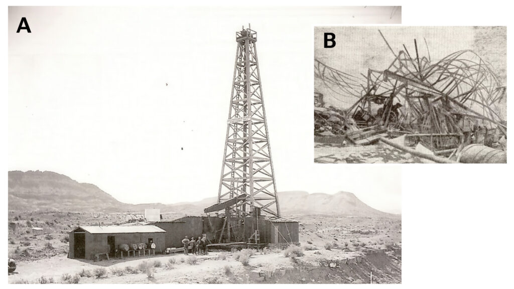
With Alsop on board, the company went to work at drilling deeper at its two newly acquired wells in August 1933. At a time when most drilling derricks were still made of wood and usually 84-feet tall, the new derrick for the Escalante No. 2 well was steel and 120-feet tall. The drilling equipment was state-of-the-art and the steel rotary table was powered by several large electric motors.
By March of 1935, the Escalante No. 2 well had reached a depth of 4,250 feet. Utah well records from the 1930s are often incomplete and the many articles about the Escalante well explosion contain varying and contradictory accounts; some articles state that the depth was about 3,700 feet. Various reports indicate that Arrowhead believed that a 48.5-foot-thick oil-saturated sandstone, likely based on shows in drill cuttings, was encountered at 3,200 feet, possibly near the base of the Queantoweap Sandstone. Additionally, some reports state that three days before the explosion, test shooting or fracking of the well resulted in a 15-foot-high flare of gas. However, oil had yet to flow to the surface. Alsop determined that a major shooting of the oil-saturated zone would free up the oil that was surely locked in the rocks at depth and bring in the well as a gusher. So confident of success, he also made the fateful decision to turn the event into a public spectacle inviting all employees, investors and many townspeople from St. George to attend.
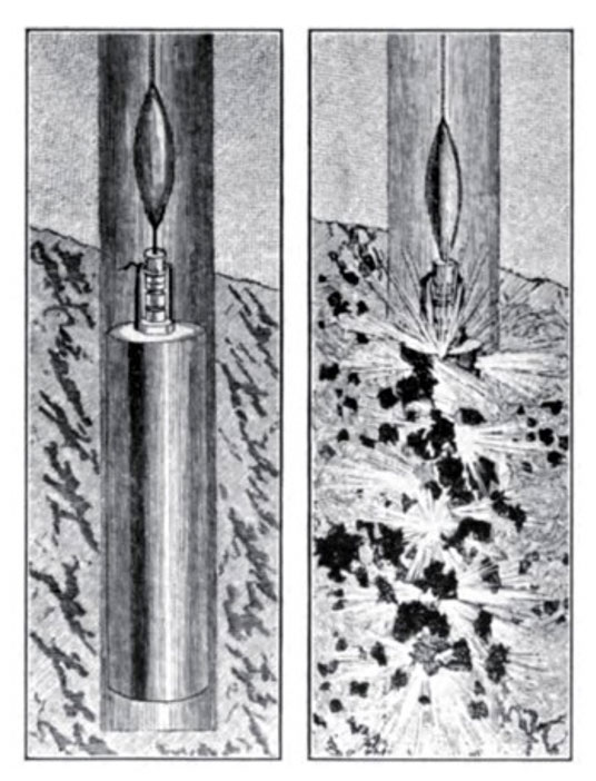
Fracturing wells to stimulate oil flow was nothing new in 1935; however, the technique of hydraulic fracturing involving high pressures, various frac’ fluids and proppants was not commercially developed until 1949. Before then, fracturing used torpedoes filled with dynamite and nitroglycerin, which were lowered down a water-filled, open drill hole via a rope or wire and detonated at the potential oil-bearing interval, generally at the bottom of the well. An iron weight was dropped down the hole to hit a percussion cap on top of the torpedo and set off the explosives. This method was developed by American Civil War veteran Col. Edward A.L. Roberts who patented his exploding “Roberts torpedo” shortly after the war ended. While participating (on the Union’s side) in the Battle of Fredericksburg on Dec. 13, 1862, along Virginia’s Rappahannock River halfway between Washington, D.C., and the Confederate capital of Richmond, Roberts observed that the explosion of artillery shells after hitting the water were compressed or “tamped.” He incorporated these observations into his shooting instructions – to tamp wells by filling them with water before using the torpedoes, thus helping to keep the explosion more confined and not escape upward. Many operators illegally produced their own torpedoes rather than pay the perceived high cost – $100 to $200 each – for a Roberts torpedo. After Roberts’s patent expired in 1879, new torpedo designs included an explosive-filled tube with the fuse wound around it connected to a blasting cap and placed in a larger, sand-packed tube; after the fuse was lit the torpedo was quickly dropped down the wellbore. The intent of these modifications was to prevent premature detonations.
Arrowhead decided that only a “full shoot” would do the trick to bring oil to the surface. This required an assembly of six, 10-foot-long, 5-inch-diameter torpedoes containing a total of 2,500 pounds of dynamite and nitroglycerine. Each torpedo had two blasting caps connected to wires for an electronic detonation. They were hooked together and suspended from the top of the derrick. The well had been tamped (filled with water). The rig crew began lowering the explosive-laden assembly down the well three days before the planned shoot without incident. Only the last torpedo remained suspended above the derrick floor as final preparations were made for the planned shoot on March 6.
Even then, spectators began to gather around the rig, some on the derrick floor in anticipation of the pending shoot.
The driller responsible for the operation and setting off the torpedo charges did not like what was happening and expressed his concerns of the dangers directly to Alsop. After a heated argument, Alsop remained steadfast in his plans for a public event and the driller, as well as some others within earshot of the exchange between the two men, left the drill site, likely saving their lives in the process.
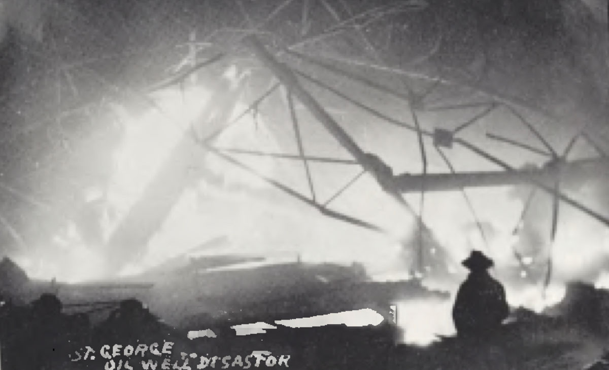
Nearly 100 spectators, including families, investors and company workers, gathered at the Escalante No. 2 drill site on the evening of March 6, 1935. They were excited to see the shoot and the resulting flow of oil that would surely ensue and help end their economic woes. The sixth torpedo remained suspended above the derrick floor.
At 9:40 p.m. as the crew started to lower it and the rest of the torpedo assembly down the well, the unthinkable occurred: the torpedo prematurely exploded, also igniting the five already in the hole. The result was a massive blast that instantly destroyed the steel derrick and showered the throngs of hapless innocent onlookers with shrapnel from the torpedoes, the steel girders of the rig, rocks, timbers and iron drilling debris. The erupting flames lit up the night sky and could be seen as far away as the town of Hurricane, Utah, 18 miles to the northeast. People in St. George thought there had been an earthquake until they saw the flames to the south. Hundreds of shocked residents rushed to scene, arriving to find the rig in a heap of smoldering, tangled steel, the ghastly-looking bodies of the dead, and many severely injured in dire need of medical attention.
Those with vehicles were immediately pressed into service transporting victims to the hospital in St. George while search and rescue continued through the night. Nearby powerlines shredded by the blast made the recovery operations more difficult and additionally dangerous, while fires at the site were still being battled.
The Aftermath
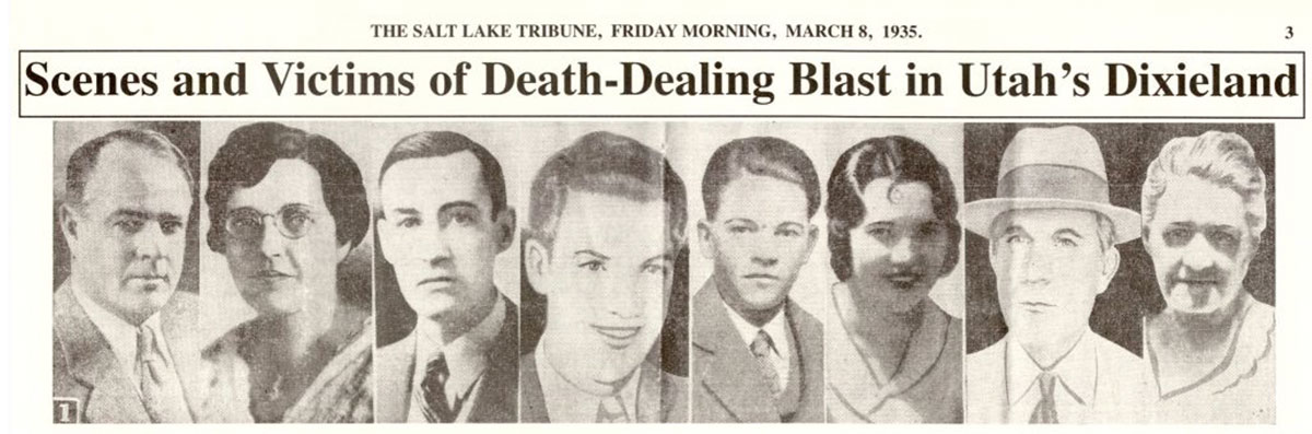
The early morning hours of March 7 revealed the leveled rig, a large crater where the well had been, and the grotesque remains of many of the dead. Nine Arrowhead employees and spectators had been killed the moment the explosion occurred, including Alsop and his wife Mabel, and another died at the local hospital the next day. One body was never recovered.
A witness had parked his car about 120 feet from the well, thinking it a safe distance. However, the blast ripped the roof off, but miraculously, the man survived relatively unharmed. Others were not so lucky, recovering but with both physical and emotional scars for life. Families had lost their husbands, fathers, wives, mothers, sons and daughters. The story that ran in the March 8, 1935, edition of the Salt Lake Tribune stated, “It took a split second Wednesday night at 9:30 o’clock to turn a semicivic celebration into a catastrophe …”
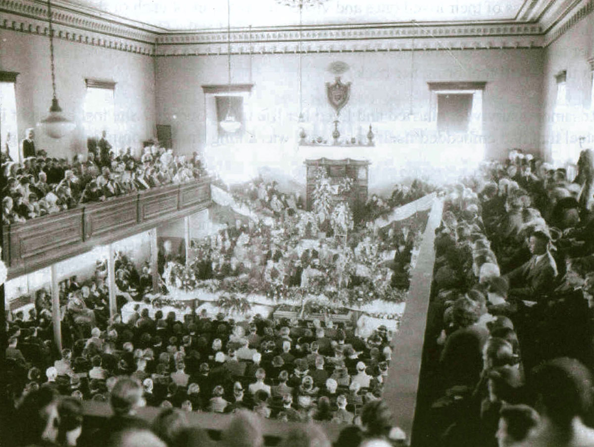
A joint funeral service was held the afternoon of March 8, 1935, in the historic Mormon St. George Tabernacle, for seven victims of the disaster. Approximately 2,000 mourners attended the solemn service. Businesses were closed in St. George that day out of respect.
Not to be deterred by the loss of the drilling derrick, surface equipment and 10 souls, including their general manager Charles Alsop, Arrowhead went back to work on the Escalante No. 2 well about a month after the disaster. They quickly announced their plans to the public, secured continued and additional financial support, hired replacement personnel and brought in a new drilling rig. Arrowhead remained convinced that the well would eventually produce oil.
Drilling operations continued into the next year. However, after reaching a depth of 4,114 feet in the Callville Limestone, the same formation that would produce non-commercial oil at Anderson Junction field in the late 1960s, 23 miles to the northeast, the Escalante No. 2 well was completed on June 6, 1936, as a dry hole and abandoned for good.
Many questions immediately followed the tragedy and remain unanswered even today.
First and foremost, what was the root cause of the explosion? Did friction against the cable ignite the charges? Was it faulty wiring? Were the torpedoes a standard Roberts type, a knockoff, or built onsite? Was it related to the quality of the explosives?
Geologically, was an oil-saturated sandstone interval encountered while drilling the Escalante No. 2 well or was the evidence (presumably live oil in drill cuttings) misidentified? Those involved in the well sincerely had faith that such a large structure as Bloomington dome just had to produce oil. All the people who might have known the answers to these questions were either killed in the explosion or have long since passed away, and thus, we will likely never know.
In 1951, the last attempt to discover oil on Bloomington dome was by the California Oil St. George Unit No. 1, the only well drilled on the structure since 1936. Reaching a depth of 6,347 feet in the Devonian Muddy Peak Dolomite, this well also failed to find any oil. Not generating the local interest like that of the doomed souls in 1935, there were no reports of injuries to either the rig crew or any drill site visitors.
Lessons
Despite large structures and other traps and source rocks in the Paleozoic section, commercial oil and gas deposits remain an illusive dream in southwestern-most Utah. The tragedy of the Escalante well explosion resulted in hard-learned lessons:
- Large surface anticlines might represent great traps but they require good reservoir rocks and the right timing of oil migration to contain oil and gas. In the case of the Virgin anticline and its subsidiary structures like Bloomington dome, the Lower Jurassic Navajo Sandstone would have made an excellent reservoir, but it was eroded away over the last 5 million years. The Navajo serves as the primary shallow aquifer for culinary water used in the St. George metropolitan area to the north and is a major oil reservoir at Covenant field in the central Utah thrust belt to the northeast (see the April 2005 EXPLORER article, “Utah – Who Knew.”)
- Drilling sites are very dangerous and no place for sightseers and the curious who have no business being there, as was the case in 1935 and now.
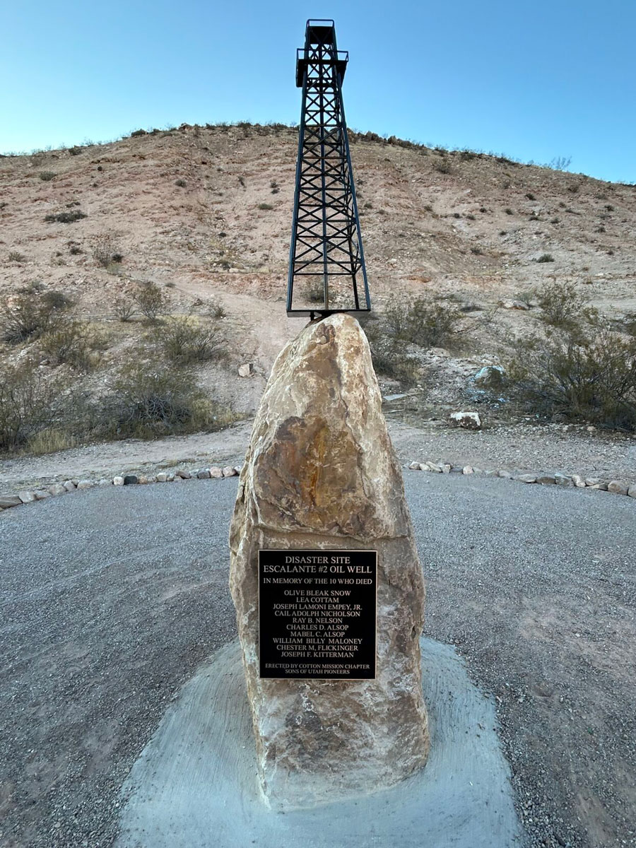
The land where the calamity occurred is now owned by the Utah State School and Institutional Trust Lands Administration. For nearly 90 years, the site offered no evidence of the 1935 tragedy – just dirt, sand, rock, some old boards and junk dumped there by locals. Finally, in 2024 it was cleaned up and a monument was erected and dedicated by the Cotton Mission Chapter of the Sons of Utah Pioneers to the victims of the catastrophe. Many descendants of these victims were in attendance. The monument serves as a somber reminder of the horrific Escalante No. 2 well explosion, which remains Utah’s worst oil field accident to this day.