


What are ultramafic rocks, where, and how do we find them?
Ultramafic rocks are often an enigma to petroleum geoscientists, yet they are key to geological hydrogen production, stimulated hydrogen generation and carbon mineralization. While hydrocarbons are not typically sought within these rocks, they offer significant economic potential, hosting nickel-copper-cobalt (Ni-Cu-Co), platinum-group elements (PGE), chromium and even diamonds. Ultramafic rock examples include dunite, harzburgite, peridotite and kimberlite. Characterized by high iron and magnesium content, and reduced silica levels, these rocks exhibit unique physical and chemical properties that greatly differ from sedimentary rocks.
Ultramafic rocks are commonly found in ophiolite complexes along convergent plate boundaries in subduction zones. Major exposures of these rocks are found in the east and west coasts of the United States, Chile, India, Indonesia, Australia and numerous localities worldwide.
Naturally occurring geologic hydrogen and stimulated hydrogen can be produced from ultramafic rocks via serpentinization. These rocks can also be used for carbon mineralization. Their high concentrations of iron, magnesium and calcium enable reactions with CO2 to form stable carbonate minerals, such as magnesite, calcite and siderite, permanently sequestering CO2 in mineral form.
Most studies on ultramafic rocks to date focused on surface mapping and outcrop analysis rather than deep subsurface exploration. The complex mineralogy, geometries and physical and chemical properties of ultramafic rocks present challenges for conventional exploration tools, making it difficult to identify and map them in the subsurface.
Unaltered ultramafic rocks have higher magnetic susceptibility than other rock types, along with relatively high density compared to sedimentary rocks. During serpentinization, these rocks can exhibit an increase in magnetic susceptibility due to the formation of magnetite, while their density decreases due to the destruction of high-density minerals such as olivine and pyroxene.
As part of the Bureau of Economic Geology’s ongoing research on subsurface hydrogen storage, stimulation and carbon mineralization, new concepts and methodologies are being developed to better understand the physics and chemistry of mafic and ultramafic rocks.
In what follows, we show an example using high-resolution aeromagnetic data and petrophysical property-constrained 3-D inversion to estimate the volume of ultramafic rocks in the subsurface.
The Resurgence of Potential Field Geophysics
Potential field geophysics (gravity, magnetic and electromagnetic methods) will have a large role in subsurface exploration of ultramafic rocks. Often, such data are publicly available at the country-wide scale (doi.org/10.3133/ofr02414). These datasets are essential for interpreting regional subsurface structures and conducting high-level screenings to locate ultramafic rocks. However, these datasets frequently suffer from poor spatial resolution, which obscures the true subsurface complexities and local features of interest.
To address this, we need modern high-resolution potential field data with closer station/flight-line spacing, lower flight altitudes and finer grid spacing, optimized to image drillable targets at specific depths while staying within budget constraints. High-resolution data of this kind are acquired by private industry and, in some cases, by federal and state agencies, such as through the USGS MRI program: https://www.usgs.gov/earth-mapping-resources-initiative-earth-mri. New high-resolution potential field data collection and processing efforts are underway at various places and are expected to grow.
High-Resolution Aeromagnetic Data: An Example from Central Alaska
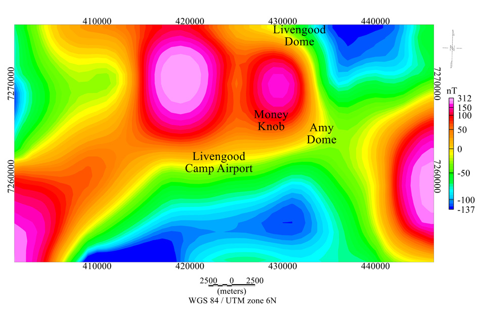
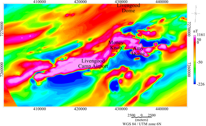
In this study, we use high-resolution aeromagnetic survey data from the Livengood Terrane in central Alaska, near Fairbanks. The overall area contains serpentinized harzburgite and minor dunite as well as volcanic and sedimentary rocks. The dataset is available from the Alaska Department of Natural Resources Division of Geological & Geophysical Surveys (https://doi.org/10.14509/30756). We compare it to the publicly available nationwide dataset from USGS. While the nationwide USGS data have a flight line spacing of about 4.8-9.6 kilometers, the recently collected high-resolution data features a flight line spacing of 0.4 kilometers, providing significantly improved data quality for accurate subsurface imaging (figures 1 and 2).
The high-resolution aeromagnetic anomaly map shows that the Livengood Terrane is characterized by prominent bipolar magnetic anomalies with a northeast-southwest orientation (figure 2). This high magnitude bi-polar magnetic anomaly may be attributed to Livengood ophiolite, which consists of a long, discontinuous belt of sheared, serpentinized harzburgite with minor dunite.
3-D Volumetric Estimates of Ultramafic Rocks
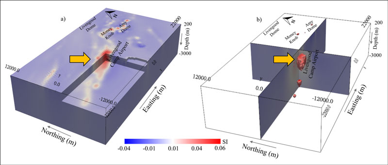
To derive the 3-D magnetic susceptibility distribution in our selected study area, we performed a 3-D inversion of high-resolution aeromagnetic data using a Gauss-Newton, gradient-based approach. We incorporated measured susceptibility data and literature values to constrain the upper and lower bounds of susceptibility contrast values within the inversion model.
The L2 norm magnetic inversion model reveals one prominent ultramafic rock body near the Livengood Camp airport, exhibiting high-susceptibility (greater than 0.03 SI), along with several adjacent smaller high-susceptibility geobodies located at various depths. Our estimated volume for these geobodies is about 7 cubic kilometers. These volume estimates provide a basis for assessing ultimate resource and storage potential, and when reaction kinetics are taken into consideration, they can provide a more representative estimate for hydrogen generation and carbon storage.
The combined use of high-resolution aeromagnetic data and 3-D inversion along with core-calibrated petrophysical measurements, enables the mapping and estimation of the 3-D distribution of several ultramafic geobodies in the shallow subsurface. It is still an area of early research. It is an understatement that more research on mafic and ultramafic rocks is needed.
Acknowledgment: The study is funded by the U.S. Department of Energy, project DE-FE0032249. Thanks to Sequent for donating Oasis-Montaj software to the University of Texas at Austin.
Disclaimer: This report was prepared as an account of work sponsored by an agency of the U.S. government. Neither the U.S. government nor any agency thereof, nor any of their employees, makes any warranty, express or implied, or assumes any legal liability or responsibility for the accuracy, completeness or usefulness of any information, apparatus, product or process disclosed, or represents that its use would not infringe privately owned rights. Reference herein to any specific commercial product, process or service by trade name, trademark, manufacturer or otherwise does not necessarily constitute or imply its endorsement, recommendation, or favoring by the United States Government or any agency thereof. The views and opinions of authors expressed herein do not necessarily state or reflect those of the United States Government or any agency thereof.