
Structural geologist for Devon Energy Molly Turko recently attended a field trip in San Diego, Calif. hosted by Applied Stratigraphix and expert on sedimentology and stratigraphy, Tim Denko. She has been sharing her favorite geological and touristic spots with GeoLifestyle readers in a three-part series.
Here are some clips from parts one and two of her journey. Subscribe at aapg.org/geolifestyle to read all three parts in full! Part 3 is coming in April!
San Diego’s Geological Tale
The San Diego area boasts a unique geological history.Along the coast of San Diego, exposed strata are primarily Eocene deep-marine deposits (approximately 50–65 million years ago). These sandstones and siltstones record submarine fan and slope systems shed westward into a forearc basin along the active continental margin.
- Along the coast of San Diego, exposed strata are primarily Eocene deep-marine deposits (approximately 50–65 million years ago). These sandstones and siltstones record submarine fan and slope systems shed westward into a forearc basin along the active continental margin.
- During deposition, the Farallon Plate was subducting beneath North America, driving basin subsidence, sediment supply from an uplifting magmatic arc, and gravity-driven transport into deep water.
- Later Neogene transtension associated with Pacific–North American plate reorganization uplifted and faulted these deposits.
Now, that is an epic geologic story!
Stop 1: San Clemente
San Clemente beach is a perfect place to:
- Observe deepwater channel lithofacies and stratal architecture. Keep in mind that channels can be filled with anything, and it’s not always sand!
- Differentiate channel margin and thalweg depositional settings. The thalweg (channel axis or deepest part) typically shows the coarsest, thickest, most-amalgamated sandstones or conglomerates from high-energy, erosive flows.
- Channel margins feature finer-grained, thinner-bedded sands/silts, often with more mud drapes or overbank/levee deposits from waning or spilling flows.
- Learn what a bypass is. Spoiler alert: It’s an erosional surface on which whatever caused it has “bypassed” and moved along. This was new to me!
- Discuss porosity/permeability, geometry, and connectivity of deep-water channel systems. The discussions with your reservoir engineer can run wild!
Stop 2: Torrey Pines State Natural Reserve
Torrey Pines State Natural Reserve is named for the rare Pinus torreyana (tree), with roots tracing back to prehistoric times when a cooler, wetter climate supported a larger forest.
You’ll observe:
- A sharp transition from shallow tidal deposits (Del Mar Formation) to deepwater deposits (Torrey Sandstone), reflecting a major transgression likely due to tectonics. This occurs right after crossing the prominent rocky point.
- Classic tidal signatures like cyclic spring-neap bundles, oyster hash, and rip-up clasts before the transition.
- Prominent deepwater channel where the Torrey Sandstone incises into the underlying tidal Del Mar Formation, featuring large-scale cross-bedding with upflow backsets from supercritical flows. This is located after the rocky point.
Stop 3: Wipeout Beach in La Jolla
The rocks here display lobe and channel-lobe transition zone lithofacies and stacking patterns. Look for:
- Greater lateral continuity and fewer erosional surfaces than the channel complexes at San Clemente
- Higher clay content and greater critter diversity, signaling a calmer, more oxygenated environment than that in channels
- Abundant soft-sediment deformation, including epic “ball and pillow” structures and pseudonodules
- Large northeast-southwest-oriented fracture systems big enough to walk through
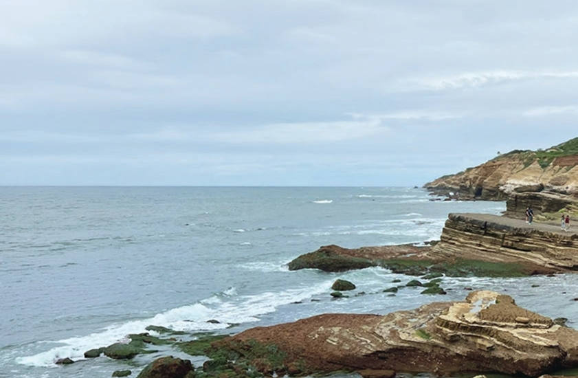
Stop 4: Cabrillo National Monument
Established in 1913, Cabrillo National Monument commemorates Juan Rodríguez Cabrillo’s 1542 landing, the first European expedition on the U.S. West Coast. It includes the historic Old Point Loma Lighthouse, panoramic bay views, solid spots for whale watching, tide pools, and military bunkers.
Head down the trails to the beach and observe:
- Medial-distal lobes facies with thinner beds and thicker muds, yet still a bit of sand
- Reduced critter diversity, indicating less oxygen, as it was a bit muddier
- Fracture spacing versus bed thickness relationships. Mechanical stratigraphy for the win!