
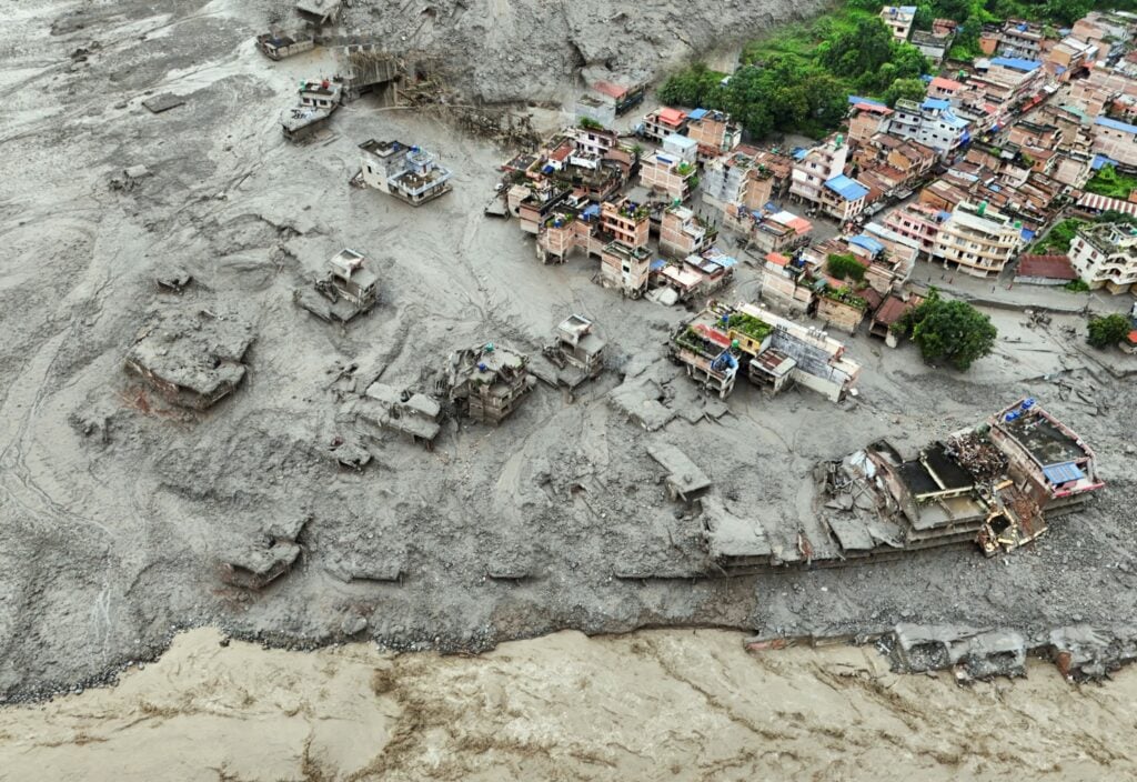
I did my PhD and Postdoc research work in the Himalayas—so topics related to Himalayan geology are close to my heart. In the early hours of Wednesday, 26 August 2026, a tragic disaster involving rock-ice collapse and catastrophic flood occurred in the Langtang Himal on the Tibet-Nepal border. This area includes Nepal’s Langtang National Park—a popular tourist and trekking site—and is home to Langtang Lirung (“Yak Pasture’s Tall Peak” in Tibetan), which is the 99th highest summit in the world at 7,234 meters.
What was the nature of the disaster? Shortly after the news broke out, speculations of all sorts surged within the mass media. Was it an earthquake, a glacial lake outburst flood, a landslide, an avalanche, or a glacial collapse? The reality is that it was a complex natural disaster.
Now, with time and better analysis of satellite images and eyewitness videos, it is clear that a landslide or bedrock-ice cover failure on a steep slope was the trigger, but it was not a simple landslide: It brought down with it a glacial cover, set in motion a debris avalanche and massive flood, and caused two sizable seismic tremors.
A Trail of Death and Destruction
As of September 5, according to The Kathmandu Post, at least 1,355 people have died, and 4,996 people are reported missing in Nepal. Of those who died or are missing in Nepal, 583 people were foreigners and tourists from more than 30 countries. On the Tibetan side, an additional 43 deaths and 519 people have been reported missing by China’s Xinhua News Agency. Of these, 261 are foreigners from 23 countries. According to the U.S. State Department, 85 Americans are among the confirmed missing.
The debris-laden flood buried and washed away large parts of villages and towns, including homes and schools, damaged hydropower facilities, and destroyed bridges and roads. Nepal’s government estimates that reconstruction would cost $4 –5 billion, or one-tenth of the country’s gross domestic product (GDP).
Anatomy of the Disaster
A detailed official report on the disaster has not yet been released. An analysis of post-event topography and pre-event data is necessary but will take more time; however, initial studies provide some details.
Satellite images suggest a chunk of rock and ice —with an area of 0.2 square kilometers —broke off the steep slope of a hanging glacial valley at 5,200 meters of elevation and fell for more than 1,200 meters onto the lower glacial valley at Lende Khola (khola means “stream” in Nepali). Lende Khola merges with the larger north-south running river —Trishuli Khola—several miles to the west. The U.S. Geological Survey placed the collapse location at 28.271 degrees North and 85.515 degrees East.
Active Geology
The Himalayan mountains have formed as the Indian tectonic plate has collided with Asia over the past 50 million years. The Indian plate continues to collide with Asia at a rate of five centimeters per year. That is why the Himalayas are still rising, and active faults, landslides, and earthquakes are common in these mountains.
Langtang Himal is made of metamorphic and granitic rocks. The metamorphic rocks formed as the rocks at the colliding edge of the Indian plate were buried deep at high temperatures and pressures before they were upthrust and exposed. The same process also melted some of the buried rocks and formed light-colored “leucogranites,” typically outcropped in the High Himalayas between Nepal and Tibet.
Seismic Activity
According to the U.S. Geological Survey, the slope failure and rock-ice avalanche caused a magnitude 5.2 seismic event at 8:37 local time. Three hours later, another seismic tremor of magnitude 4.2 occurred. This indicates that there were two slope failure events.
Catastrophic Flood
The Langtang Himal disaster was not a typical glacial lake outburst flood, and there were no reports of heavy rainfall in the days before the disaster. So, what was the source of so much water and flash floods? The answer will require further investigation than what has already occurred.
Some geologists suggest that gravitational impact melted the ice cover, as well as ice hidden under moraine sediments in the Lende valley, and that as the flood moved downstream, it picked up more water and debris.
Some scientists have also reported that the collapsed rock and ice initially dammed the Lende valley, allowing water to back up in two “barrier lakes” which subsequently burst and sent the debris-laden flood downstream in both Lende and Trishuli valleys.
Takeaway Lessons
The Langtang Himal disaster was not the first of its kind in the Himalayas. Active tectonics and the unstable landscape of these mountains combined with retreating and melting glaciers have caused natural disasters before; however, the tragic disaster on August 26 illustrates several features and lessons for us today.
- Natural disasters are not a single, clear-cut process. Whatever the trigger —a landslide, a glacial lake outburst, a volcanic eruption, or an earthquake —it may quickly cascade into a chain of processes with disastrous consequences, particularly in steep valleys confined along high mountains.
- Preparatory and early warning systems are crucial for areas prone to natural disasters. Such systems should incorporate advanced technologies (including AI-assisted analytics), focused plans, and public education.
- Geoscience studies and scientific collaboration play a critical role in mitigating casualties and damages. Studies of active faults, slope failure, earthquakes, glacial avalanches, and flash floods are not merely academic curiosities but have societal and international relevance.
- In this new age of fake AI-generated imagery for political propaganda, the role of investigative journalists, science-based reporting, and reputable mass media is becoming increasingly valuable, and all these parties deserve public support.
- Last, but certainly not least, Nepal urgently needs international help. Every bit of donation to help survivors reconstruct their homes and communities will have a positive outcome.