
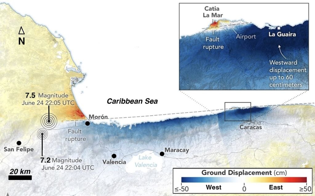
Response to the Venezuela earthquakes takes a variety of forms. While responders run to the scene and philanthropists raise money, seismologists work to understand what happened and to mitigate the impact of future disasters.
Michael Schmitz, geophysics professor, member of Venezuela’s Infrastructure Commission of the National Academy for Engineering and Habitat (ANIH) and retired member of the Venezuelan Foundation for Seismological Research (FUNVISIS), views the disaster from a scientific and humanitarian perspective.
Schmitz spent June 24 working to recover a collapsed water tunnel in the interior ranges south of Cumaná, in northeastern Venezuela’s Sucre state.
“I was on a rock site some 500 kilometers from the epicenter, I did not feel anything, but the security cameras in the tunnel evidenced minor vibrations,” he said. His internet was down at the time, so it took a while for him to receive a frantic call from his wife.
“My wife was in a public viewing in a commercial center in Caracas and it was very frightening, with some elements falling and generalized panic. Knowing I was working in the tunnel but not knowing where the epicenter was, she was really worried about not getting a response from me,” he said.
Schmitz did not apprehend the true magnitude of the disaster until he returned to Caracas the following day.
“As we approached Caracas in the taxi, I was very confused about the high seismic activity close to La Guaira, which we now know was aftershock activity,” he said.
Schmitz asked his FUNVISIS colleagues about the origin of the earthquakes, and they reported epicenters in Yumare on the Boconó fault system. Later, a former student shared reports from global seismology networks GEOFON and GCMT indicating that the epicenters were not in Yumare, but in La Guaira.
“That was the moment I understood it was the La Guaira earthquake,” Schmitz said.
Scientific discussion about epicenters will continue, but Schmitz recommended issuing a public communication stating that the earthquake had taken place in La Guaira so people could understand the extent of the damage in that area.
“We must keep in mind that the epicenter indicates just one point, but the origin of a magnitude-7.5 earthquake is a fault plane that ruptured along 200-kilometer length and 20-kilometer depth,” he said.
“As I did not feel the earthquake, I asked myself if this was real. I contacted colleagues around the world to get support for aftershock measurements, and after the first weekend we had confirmation of a total of 500 seismometers that would be installed in central Venezuela in coming weeks.”
The seismometers – devices that detect ground vibrations – will help to understand the region’s tectonics.
Schmitz spent much of his time at FUNVISIS advocating for seismic microzoning, the process of subdividing a region into zones with similar potential for hazardous earthquake effects (like ground shaking, soil liquefaction and landslides) based on local geology and soil characteristics.
“I had been pushing for seismic microzoning studies in La Guaira for over eight years without attracting interest in funding,” Schmitz said. “It was always a struggle as people did not believe that they would suffer from an earthquake.”
After a brief visit to Caracas, Schmitz returned to Cumaná, returning to his work with the collapsed water tunnel. He also pushed for detailed studies to guide future reconstruction efforts in La Guaira.
Why La Guaira?
Schmitz described how understanding the events of June 24 is key to preventing future disasters.
“There is still a big discussion on what really happened, why there was concentrated damage in La Guaira,” Schmitz said.
He identified three primary factors that led to such widespread devastation:
- A strong shaking close to many buildings (less than 2 kilometers apart), and a peak ground acceleration (PGA) code higher than the 0.3 g – 30 percent of Earth’s gravity – known to cause heavy structural damage
- Site effects caused by up to 400-meter-thick sediments in Caraballeda and possibly also Catia La Mar, the two most affected cities, as well as widespread liquefaction phenomena
- Building vulnerability in old constructions and in more recent constructions noncompliant with building codes
Some of the collapsed buildings were constructed before Caracas’s 1967 earthquake, which led to new seismic building codes in Venezuela. Others, primarily those constructed through massive government housing initiatives following 1999 landslides in the same area, did not meet building standards.
Schmitz said many of the newer buildings that collapsed should never have passed inspection. He blames improper and incomplete inspections on a lack of governmental oversight and personnel.
“In general, the public institutions are dramatically weakened in Venezuela, as many professionals left due to the almost non-existent salary,” he said. “The official minimum salary is less than 20 cents a month, with payments are given irregularly and a so-called ‘bonus,’ totals a maximum of (U.S.) $200, not even enough for food.”
A Science-Based Approach to Prevention
Schmitz said recovery of the Venezuelan infrastructure must include education, and reasonable salaries for professionals, including geoscientists.
“The knowledge of geoscientists will be much needed to understand the reasons for the disaster and give hints for the reconstruction within the microzoning projects. The oil industry itself faces big challenges with a decade without exploration, infrastructure without maintenance and many holes that need recovery,” he said.
Schmitz invited the international community to assist Venezuela in rebuilding not only its structures but also its institutions.
“Venezuela needs international support in the political and economic transition required for the reconstruction, not only of devastated La Guaira, but of the whole country,” he said.