There is a temptation to view the current wave of new activity in America’s established oil and gas basins as simply the product of higher prices or consolidation-driven efficiency gains. That view is incomplete. What is actually happening is something more profound: a systematic re-examination of the subsurface record using tools that did not exist, or were not economically accessible, when these basins were first developed. Neural networks in machine learning are reading wireline logs for bypassed pay. Distributed acoustic sensing fiber optics is mapping live fracture geometry evolution in real time. Full-waveform seismic inversion is resolving reservoir bodies below the classical tuning thickness. And geochemical analysis of produced water is revealing that the brines co-produced with oil and gas can carry lithium, iodine, bromine, and other critical minerals in commercially significant concentrations.
The geological reasons these opportunities exist are not mysterious. They are the product of three interacting phenomena: original depositional heterogeneity that early well logs could not resolve at the required scale; engineering-era limitations that left significant segments of stimulated intervals unperforated or unstimulated; and evolving economic thresholds for secondary products (critical minerals, sequestered CO2, energy storage behind-the-meter power) that have transformed waste streams into revenue streams. Understanding each of these phenomena is the geoscientist’s entry point into the new opportunity landscape.
Why So Much Was Left Behind: A Formation-by-Formation Assessment
Every major U.S. producing formation carries a characteristic type of bypassed resource, rooted in its depositional system and diagenetic history. Recognizing the formation-specific bypass mechanism is the first step in identifying where the technology can be profitably applied.
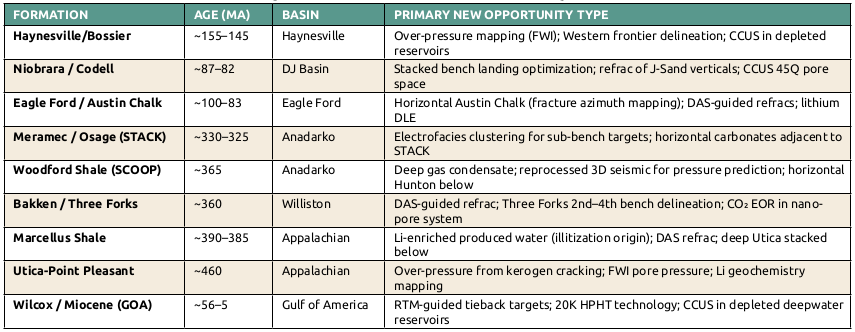
The Eagle Ford Shale and Austin Chalk (Late Cretaceous): The Eagle Ford’s carbonate-rich mudrock was deposited in a shallow, oxygen-restricted seaway environment. Its lateral heterogeneity – particularly the interplay between calcareous-rich and clay-rich laminae – controls brittleness and hydraulic fracture height containment. Early completions (2010–15) used perforation cluster spacings of 50 to 150 feet with uniform fracture fluid designs that did not account for this laminar variability; distributed-acoustic-sensing fiber analysis of those vintage wells now shows that 30 to 40 percent of perforation clusters never received significant fluid. The overlying Austin Chalk, a bioturbated to laminated pelagic carbonate, was produced as a vertical-well natural fracture target in the 1980s and ‘90s. Its fracture permeability network is geometrically anisotropic – meaning horizontal laterals steered perpendicular to the dominant fracture azimuth can intercept an order-of-magnitude more fractures per unit lateral length than the vertical wells that defined the play’s early history.
The Middle Bakken and Three Forks (Devonian–Mississippian, about 360 million years ago): The Middle Bakken Member is a hybrid carbonate-siliciclastic unit deposited as a complex of distal shallow-marine siltstones, dolomitic siltstones, and packstones in the intracratonic Williston Basin. Its reservoir quality is controlled by a combination of primary interparticle porosity and diagenetic dolomitization – both highly variable at the lateral scale of a three-mile well bore. Early Middle Bakken wells used 30-stage completion designs that, DAS analysis now confirms, consistently saw the heel-third of the lateral dominate fluid injection. The Three Forks Formation immediately beneath is four-benched, with the second, third, and fourth benches showing distinctly different lithofacies from the well-characterized first bench. The second bench, being most similar to the first bench in its dolomitic siltstone character but slightly finer-grained, has seen the most successful recent delineation. Enhanced-oil-recovery potential in the Bakken is rooted in its very low primary recovery factor – only 5 to 8 percent of original oil in place recovered – owing to the ultra-tight matrix and near-complete confinement of hydrocarbons to microfractures and nanopores.
The Marcellus and Utica-Point Pleasant (Devonian–Ordovician, about 390 to 460 million years ago): The Marcellus Shale is a black, organic-rich, pyritic mudrock deposited in an anoxic deepwater setting during the Acadian orogeny. Its lithofacies heterogeneity – particularly the presence of interbedded volcanic ash layers (bentonites) that concentrate lithium through ion exchange processes – is the geological explanation for its anomalously high produced-water lithium concentrations. The U.S. Department of Energy’s National Energy Technology Laboratory’s 2024 research confirmed that Marcellus formation water in southwest Pennsylvania carries 70 to 200 milligrams of lithium per liter, with lithium concentrations increasing with depth and thermal maturity in a pattern consistent with diagenetic clay mineral transformation (specifically, smectite-to-illite conversion that releases lithium into formation water at temperatures above about 80 degrees Celsius).
The deep Utica-Point Pleasant (Ordovician, about 460 million years ago) is a finer-grained, calcareous mudrock-limestone couplet deposited in a carbonate ramp setting that predates the Taconic orogen. Its over-pressured condition at depths of 12,000 to 14,000 feet in western Pennsylvania – where pressure gradients of 0.85 to 0.95 pounds per square inch per foot are documented – is the result of hydrocarbon generation from Type II kerogen that exceeded the expulsion efficiency of the tight matrix. That over-pressure is the engineering driver of the extraordinary initial production rates (up to 72 million cubic feet per day) being recorded in early deep Utica wells: the formation is essentially its own drive mechanism. However, if operators miss the optimal sweet spot or fail to properly differentiate the distinct, high-producing Point Pleasant limestone from surrounding shale, there can be bypassed pay.
The Haynesville-Bossier (Late Jurassic, about 155 to 145 million years ago): The Haynesville Shale is a thermally over-mature, over-pressured siliceous mudrock deposited in an intra-continental rift setting during Late Jurassic rifting of the Gulf of Mexico. Its depth gradient is its defining geological characteristic: moving westward from the traditional core in DeSoto and Bossier parishes (Louisiana) into Robertson and Leon counties (Texas), the formation deepens from about 10,500 to 19,000 feet and pressure gradients increase from 0.7 to 0.92 psi per foot. This depth gradient controls the “Western Haynesville” opportunity: at greater depths, higher reservoir energy means higher initial production rates and larger estimated ultimate recoveries per well (about 32 billion cubic feet at depth versus about 11 Bcf in the shallower core), but also higher completion costs and stricter high-pressure/high-temperature equipment requirements. The geological question driving current exploration is the lateral continuity of the over-pressure cell – mapping the transition from normal pressure to over-pressure using basin-scale pore pressure analysis is the highest-value geophysical work in the Haynesville today.
The AI and Data Analytics Toolkit: What’s Actually Being Used
The phrase “AI in oil and gas” covers a remarkably wide-ranging and varied set of techniques. For geoscientists evaluating these basin opportunities, it is important to distinguish between the specific algorithmic approaches being deployed, because each is optimally suited to a different type of subsurface problem.
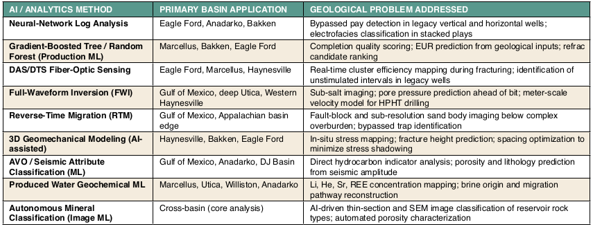
Machine-learning log analysis; finding the bypassed intervals: The most operationally mature AI application in the non-Permian Basin opportunity space is neural-network-based wireline log analysis for bypassed pay identification. The approach trains multi-layer models on a curated dataset of log curves (gamma ray, resistivity, porosity, bulk density) from wells with known production histories, then applies the trained model to legacy wells where the original completion team might not have recognized pay intervals – either because log quality was inadequate, economic thresholds were different, or the target formation was not yet being developed.
Continental Resources used this approach in Garvin County (Anadarko Basin) to rescreen 450 legacy vertical Springer tight-sand wells. The neural network identified 62 wells with bypassed upper Springer intervals by detecting resistivity anomalies and porosity crossovers that were consistent with the hydrocarbon signatures in the training data but had been missed in original completion decisions. The geological validation – confirming that the flagged intervals were genuinely bypassed, not simply non-productive zones – required integration of core data and cuttings descriptions from nearby control wells.
A technically distinct but related application is unsupervised clustering of log curves for electrofacies classification in stacked-pay environments. In the Anadarko’s STACK play, where the Meramec, Osage, and Woodford benches have overlapping log signatures in some areas, k-means and hierarchical clustering of multivariate log vectors can identify sub-bench facies boundaries that are not apparent in traditional single-curve analysis. Devon Energy’s Osage and Meramec Formation delineation program used electrofacies clustering to differentiate productive wackestone-packstone facies from tight mudstone intervals within the broader Osage section, enabling targeted perforation designs that improved cluster efficiency by an estimated 25 to 40 percent.
DAS/DTS fiber optics; real-time fracture surveillance: Distributed acoustic sensing and distributed temperature sensing deployed on permanently installed fiber-optic cables represent the most direct observational technology for measuring what a hydraulic fracture program actually achieved, versus what was designed. DAS responds to acoustic signals generated by fluid movement, fracture propagation, and proppant settling; DTS measures temperature changes along the fiber that reflect fluid entry and heat exchange with the formation.
The geological insight enabled by DAS/DTS is the identification of cluster efficiency heterogeneity – the degree to which different perforation clusters in a multi-stage horizontal completion contribute to production. In virtually every multi-stage horizontal well studied with DAS fiber, a minority of clusters (typically 30 to 50 percent) account for the majority (60 to 80 percent) of initial production. The spatial pattern of cluster efficiency correlates with geological variables: natural fracture density, in-situ stress heterogeneity, reservoir quality variability, and proximity to faults. Identifying what geological factors predict low cluster efficiency is the key geoscience contribution to refrac target selection.
ConocoPhillips acquired Marathon Oil’s Eagle Ford refrac program that used DAS analysis of a 2014 horizontal well to determine that 38 percent of its original perforation clusters had never received significant fluid. The geological explanation — stress shadowing from adjacent producing wells in the tight carbonate laminate — was confirmed by comparison of the DAS cluster efficiency map with a 3D geomechanical model built from dipole sonic logs. This integrated geomechanical-DAS workflow is now a recommended best practice for any operator considering refracs in mature tight-carbonate plays.
What DAS Fiber Actually Measures: A Geoscientist’s Primer
Distributed Acoustic Sensing (DAS) works by sending laser pulses down a fiber-optic cable and measuring the backscattered light (Rayleigh scattering) that changes in response to acoustic vibrations along the cable. In a hydraulic fracturing context, fluid entry, fracture propagation, and proppant transport all generate characteristic acoustic signatures at specific depths. The signal is sampled at centimeter-scale spatial resolution along the entire wellbore length simultaneously — something no conventional gauge network can achieve. DTS complements DAS by measuring temperature: warm fluid entry from the reservoir shows as thermal anomalies, and cool fluid zones indicate isolation from the fracture network. Together, DAS+DTS provides a four-dimensional picture (depth, time, acoustic, thermal) of fracture behavior that was simply unavailable to completion engineers before 2015.
FWI and RTM: Resolving What Legacy Seismic Missed
Reverse-time migration and full-waveform inversion are computationally intensive seismic processing algorithms that were impractical for basin-scale application before approximately 2018, when graphical processing unit acceleration made them commercially feasible on legacy 3-D seismic datasets.
RTM produces an image of the subsurface by simulating wave propagation backward from receiver to source using the full elastic wavefield – including turning waves and multiples that conventional Kirchhoff migration discards. This produces dramatically improved imaging below salt bodies and in areas of complex overburden, which is why RTM has been transformative in the deepwater Gulf of America (Mexico). Talos Energy’s identification of a bypassed Miocene fault-block closure at Green Canyon Block 110 using TGS-reprocessed RTM seismic – a structure invisible in the original 1998 Kirchhoff-migration volume – is a textbook example of geological information that was physically present in the raw seismic data but required modern processing to resolve.
FWI goes further by simultaneously updating both the velocity model and the reflectivity image in an iterative fashion, minimizing the misfit between simulated and observed waveforms. The result is a velocity model with meter-scale lateral resolution – compared to the kilometer-scale resolution of conventional tomography – that enables geologists to map reservoir property variations (porosity, fluid saturation) at the inter-well scale. In the deep Utica of western Pennsylvania, FWI-derived velocity models are being used to predict pore-pressure gradients ahead of the drill bit, critical for managing the well-control risks associated with drilling into 14,000-ft, 0.92-psi/ft over-pressured reservoirs.
AI-Driven Completion Diagnostics: Connecting Geology to Engineering
The newest frontier in applied AI for the non-Permian opportunity space is end-to-end completion optimization – integrating geological inputs (reservoir quality, natural fracture density, in-situ stress), engineering parameters (cluster spacing, fluid volume, proppant loading), and production data into a single predictive model that recommends completion designs for new wells and refrac candidates simultaneously.
SLB’s Completion Advisor and ProPetro’s AI-driven frac diagnostics platform both use gradient-boosted ensemble models trained on thousands of Appalachian, Eagle Ford, and Bakken wells to predict cluster efficiency and estimated ultimate recovery as a function of completion design parameters, given a specific geological context. The geological context inputs include: brittle-ductile ratio from log-derived elastic properties, minimum horizontal stress contrast from dipole sonic, total organic carbon from spectral gamma ray, and natural fracture intensity from image logs or borehole microseismic. These platforms are effectively closing the loop between geoscience and completion engineering that was historically open.
Critical Minerals: The Geochemistry Rewriting Produced Water Value
The geological explanation for critical mineral enrichment in U.S. basin formation waters is formation-specific and requires careful geochemical reasoning to understand – and to evaluate commercially.
Lithium in Marcellus and Utica Produced Water: The isotopic composition of Marcellus and Utica-Point Pleasant produced water (as characterized by δ7Li, δ11B, and δ138Ba measurements) is consistent with formation water origin from relics of evaporated Precambrian seawater that has subsequently undergone diagenetic modification. The key lithium enrichment mechanism is smectite-to-illite transformation during burial diagenesis at temperatures above about 80-degrees Celsius: illitization preferentially releases 6Li into solution (the lighter isotope), producing lithium-enriched, isotopically light (low δ7Li) formation waters at high thermal maturities. This explains why deeper, more thermally mature Utica-Point Pleasant wells carry the highest lithium concentrations and lowest δ7Li values – a geochemical fingerprint that enables spatial prediction of lithium-enriched brine zones across the basin.
Helium in the Williston and Anadarko Basins: Helium in natural gas is radiogenic in origin, produced by alpha decay of uranium and thorium in basement rocks and then migrating upward into trapping structures over geologic time. In the Williston Basin’s Saskatchewan extension, the source is Precambrian granitic basement enriched in uranium and thorium; helium accumulated in Lower Paleozoic (Cambrian Deadwood Formation and Ordovician equivalents) structural traps above the basement. In the Anadarko Basin’s Hugoton-Panhandle complex, the same process operated over the Precambrian basement of the Anadarko aulacogen. The key exploration observation is that helium concentration is structurally controlled, not stratigraphically: the highest helium concentrations occur in structural highs above basement uranium anomalies. Radiometric basement surveys (airborne spectrometry) and subsurface uranium-thorium maps from geophysical well logs can be used to predict helium-prospective areas without drilling.
Lithium in Appalachian Pegmatites (USGS, April 2026): The April 2026 USGS assessment of undiscovered Appalachian lithium – 2.3 million metric tonnes in pegmatite formations of the southern and northern Appalachians – represents a different geological target from produced-water lithium extraction. Pegmatites are coarse-grained igneous bodies that crystallize during the final stages of granitic magma cooling, concentrating incompatible elements (including lithium, cesium, rubidium, and rare Earth elements) into specific mineral phases. The primary lithium-bearing mineral in Appalachian pegmatites is spodumene (LiAlSi₂O₆), which occurs in the Carolinas and New England in Late Proterozoic to Early Paleozoic metamorphic terranes. The spatial correlation with the Taconic and Acadian orogens – magmatic arcs that intruded lithium-enriched metasedimentary sequences – is the geological framework for predicting undiscovered pegmatite Li deposits.
One of the most productive geoscience frameworks for identifying where each category of new opportunity is most likely to be found is formation itself. Depositional environments and heat flow history control the thermal maturity of source rocks (and therefore produced-fluid geochemistry), the nature of diagenetic modification (dolomitization, silicification, illitization), and the structural setting of the basin. The table below synthesizes the relationship:
The Geoscientist’s Role in the New Opportunity Landscape
The emergence of AI and data analytics tools has not diminished the role of the petroleum geoscientist – it has elevated it. Every AI model described in this article requires geological validation. Neural network log analyses produce false positives in intervals where lithofacies transitions mimic hydrocarbon signatures; without a geologist reviewing the flagged intervals against core and cuttings data, the output is commercially unreliable. FWI velocity models require structural geological interpretation to distinguish genuine velocity anomalies from acquisition footprint artifacts. DAS fiber data requires a geomechanical model – built by a geomechanics specialist from core-measured elastic properties and image log-derived fracture orientations – to interpret cluster efficiency variations in geological terms.
More importantly, the identification of which basin, which formation, and which technological approach represents the highest-value opportunity at a given time is fundamentally a geological judgment. The relationships between formation depositional environment, diagenetic history, thermal maturity, structural setting, and the specific type of bypassed resource or new revenue stream – as summarized in the table in one of the accompanying sidebars – are the predictive frameworks that allow geoscientists to direct data analytics investment toward the most promising targets before the first pixel of seismic is reprocessed or the first fiber-optic cable is deployed.
The basins profiled in this article collectively illustrate a principle that should guide geoscientists’ contributions to the new opportunity landscape: the most valuable geological insight is not the identification of a new accumulation, but the explanation of why an existing accumulation is more resource-rich, more geochemically valuable, or more technically accessible than the current economic model assumes. That re-framing – of the familiar made strange, of the legacy made new – is the geoscientist’s unique contribution to the energy transition.
AI and Analytics Methods: A Geoscientist’s Quick Reference
Formation Guide to Opportunity