
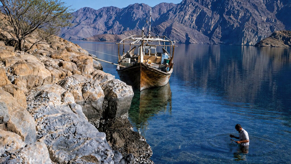
From the rocky crags of the Musandam Peninsula, on a clear day, it was possible to look across the Strait of Hormuz and watch ships sailing to and from the Persian Gulf, against the backdrop of the Iranian
coast. Toward the end of summer, vessels loaded with dates would sail from Basrah, heading south for the markets of India, Oman and East Africa. On their way around the Musandam Peninsula, crews would throw fruit into the sea as a means of securing good fortune for their voyage. It became known as the “Sainted Cape.”
Don’t Mention the Oil
On the map, the Musandam Peninsula is the pointy bit of northern Oman once described by George Martin Lees as “projecting like a spur into the vitals of Persia.” The peninsula’s striking appearance is largely the result of a collision between the Arabian and Eurasian tectonic plates, producing a dramatic landscape (see the June 2026 Explorer). Today it sits at the center of a geopolitical crisis, overlooking the Strait of Hormuz, through which most of the Gulf’s oil and LNG exports pass. Until 1971, however, the peninsula remained closed to outsiders.
“There is coffee-house babble of a mysterious race of light-skinned people who live somewhere in the mountains, shun strangers and speak a language of their own.” Thus wrote American missionary Samuel Zwemer in 1900, referring to the Shihuh tribe of the Musandam Peninsula. Each summer they descended from the Ruus Al-Jibal to live in simple huts and harvest date plantations on the coast. In winter they cultivated wheat and barley on small terraces, tended goats, and kept to themselves.
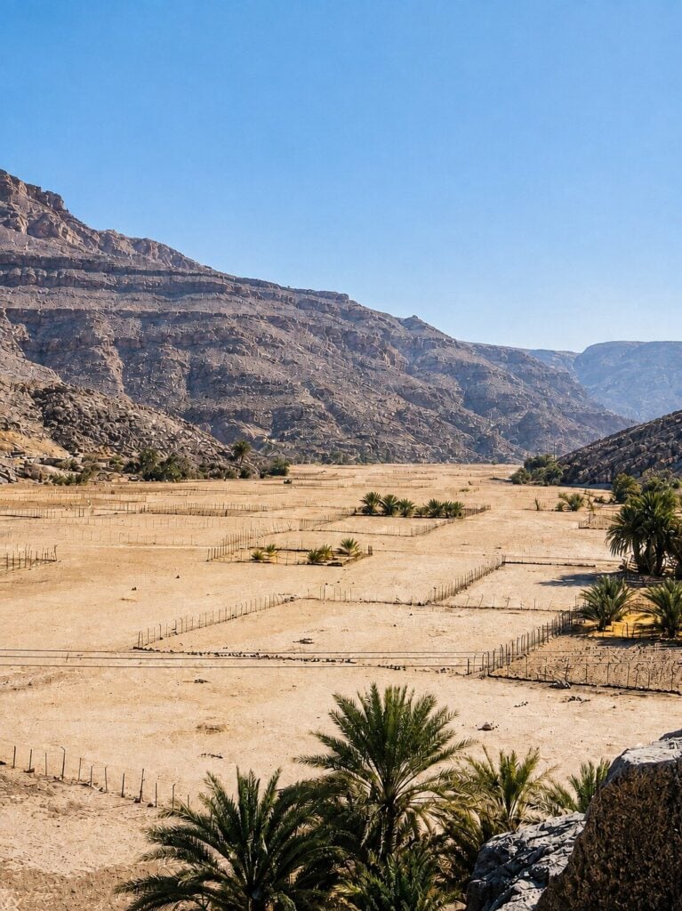
Water, not oil, was what mattered here. Flash floods sent great surges down the wadis to the sea. On the coast, the “falaj” system carried water from wells through tunnels cut into the rock, while in the mountains the Shihuh jealously guarded stone cisterns – “birkahs,” 30 meters by 6 – that held the rains through the dry season. In Kumzar, it was said, “the well will dry up at the bark of a dog.”
It was this half-mythologized world that Said bin Taimur, sultan of Oman, had sealed to outsiders. Ken Glennie’s Shell team had been denied access in the late 1960s in their geological mapping of the Oman Mountains. When the sultan’s 30-year-old son and successor Qaboos lifted the ban in 1971, the Royal Geographical Society lost no time mounting a scientific expedition, masterminded and led by the former chief geologist of BP, 67-year-old Norman Falcon.
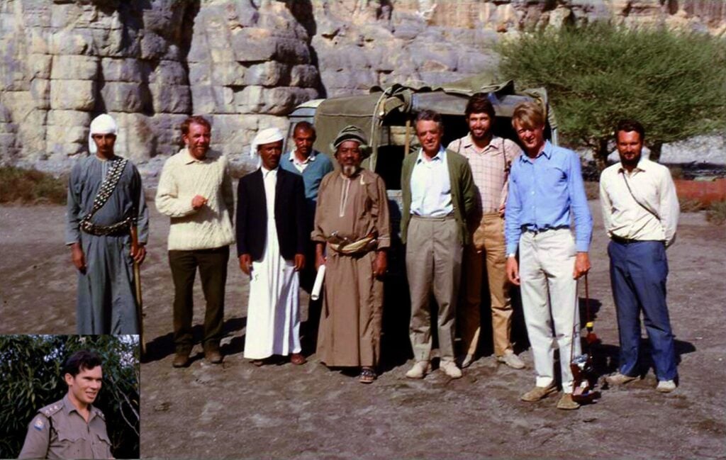
My father, Mike Morton, a 47-year-old exploration geologist formerly with the Iraq Petroleum Company, joined the RGS party as deputy leader. As expedition leader, Falcon pointed out, with some irony, the addition of another petroleum geologist risked giving the impression that this was an oil survey in disguise. Before “Fawlty Towers” made famous “Don’t mention the war!”, the watchword for the expedition was: “Don’t mention the oil.”
The expedition’s main objective was to investigate the Quaternary history of the area – how sea levels, climate and geology had changed over the last ice ages. Falcon’s particular interest was in the relationship between the geology of the Musandam mountains of Oman and the Makran mountains of Iran – this was before the theory of the subduction of the Arabian plate beneath the Eurasian plate had become firmly established.
There were six full-time members of the party: three geologists, a zoologist and two surveyors. Two motorized dhows were used: the Tarak, a 15-meter vessel hired in Dubai, and the Nasser, a 9-meter launch from Sharjah, with two Royal Navy Gemini inflatables to help with the awkward inlets. Geographer Claudio Vita-Finzi joined the expedition for five weeks and archaeologist Beatrice de Cardi for three.
The Doctors of Dib Dibba
On the evening of Friday, Nov. 12, less than a week since they had left the cold dark nights of an English winter behind, members of the RGS expedition looked on eagerly as their dhow met a cool breeze and carried them around the westerly headland of a broad bay for their first glimpse of the lights of Khasab, dropping anchor at 7.45 p.m.
At dawn, the limestone mountains appeared, soaring to 1,200 meters and cutting a jagged line against the sky. The seasonal creek Wadi al Ayn meandered out across sand flats exposed by the tide as though it had lost its way to the sea. Khasab village was an unassuming clutter of mud-brick and palm-branch dwellings, watched over by an old Portuguese fort crumbling like an abandoned sandcastle.
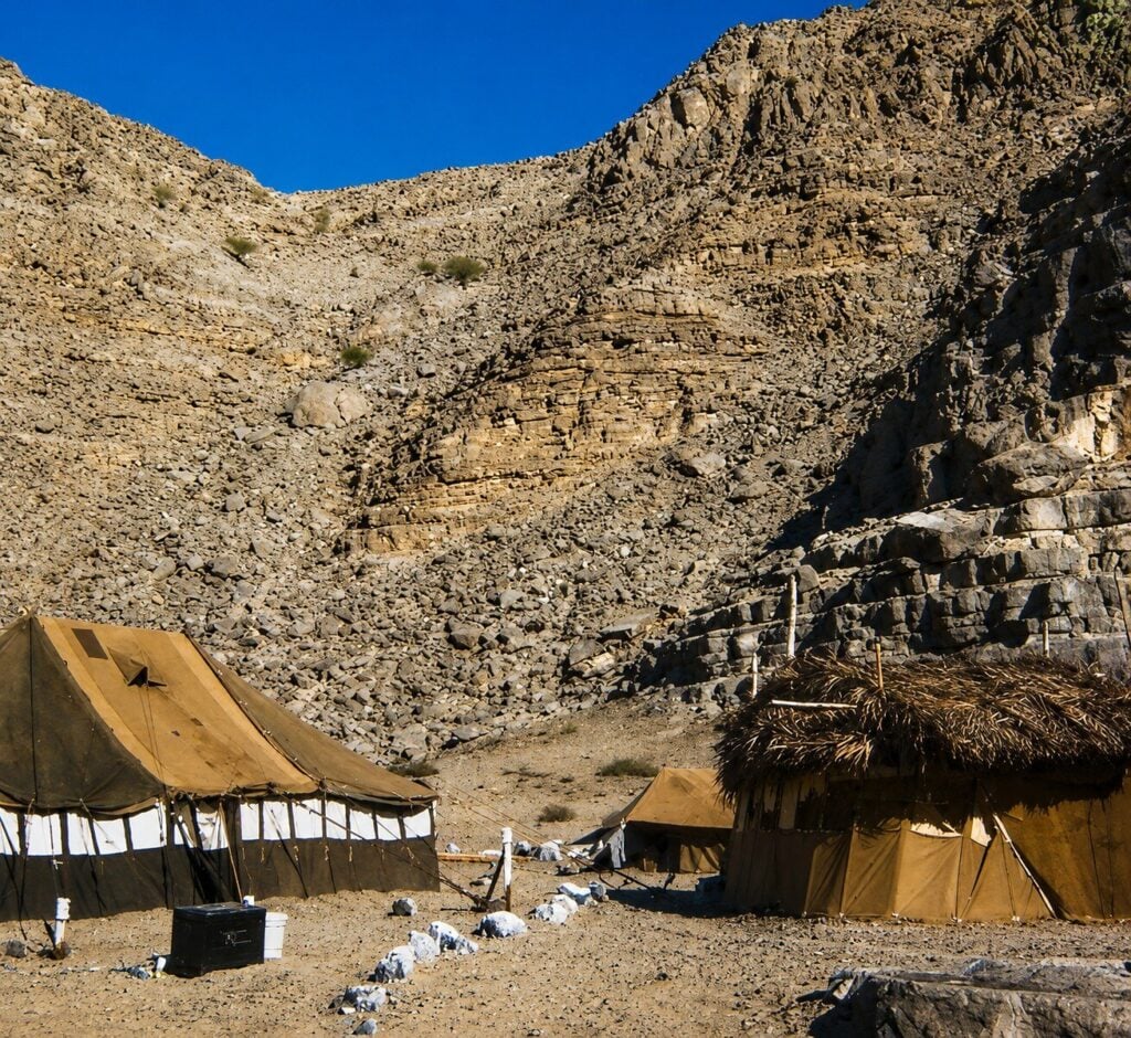
Their tented camp was established at Dib Dibba, a small re-entrant below the cliffs above Khasab Bay. De Cardi noted that the excellence of the food was reflected in the camp cat, which grew “visibly fatter” during her stay. Mike, a fluent Arabic speaker, found himself acting as front-of-house to a steady stream of visitors – the wali (governor), local sheikhs and curious tribesmen.
The zoologist, Paul Cornelius, caused some alarm among the Arab crew with his methods. A 75-centimeter sucker fish, caught and about to be thrown back, was rescued by Cornelius, injected with formalin and placed in a bucket, to the bafflement of the dhow’s crew, who were left wondering why the “fish doctor’s” patient had died.
Phillip Robinson set up an unofficial clinic for locals suffering from eye infections, heat exhaustion and minor injuries. Eye infections, particularly among the children, were common, and several camp staff caught dysentery. Then there was “Khasab fever” – an illness of cold sweats common among the laborers, which laid them low for days at a time. Robinson also drew on Mike’s rudimentary medical knowledge. When Isia, a crew member of the smaller dhow, came to them with a bad finger, Mike was all for deadening it with Nupercainal and a quick chop. In the end the patient was treated with antibiotics on the basis of “let’s see what happens.” A few weeks later, the finger had healed.
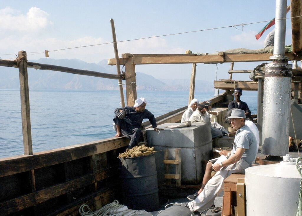
Camp life settled into a routine: Falcon crouched over a typewriter outside his tent while the breeze played havoc with his carbon paper; Derek South ground rocks into glass slides; Cornelius supervised a gang of laborers collecting narcotized fish from a tidal pool; Hugh May, in shirt and tie, set off to call on the wali. In the evening they ate beneath the light of a Tilley lamp, their starter a bowl of soup with small beetles swimming about in it.
Alarms and Excursions
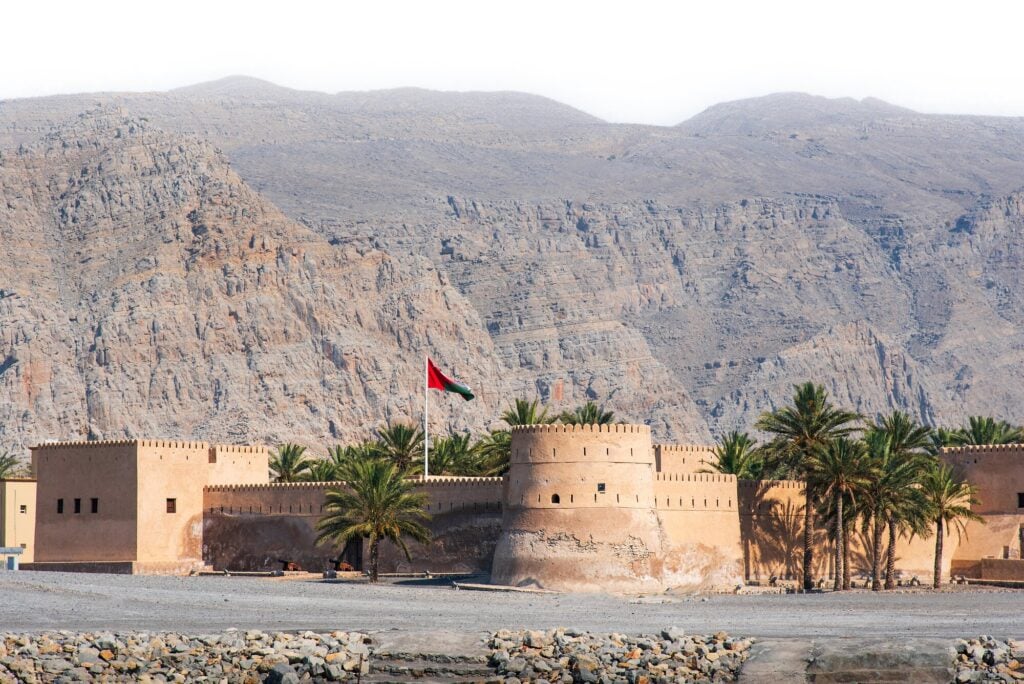
Suddenly one morning they were woken by the thump of a cannon from the fort’s battlements. It was 7 a.m., and this marked the end of the Ramadan fast and the start of Eid al-Fitr. The following day the party went to pay their respects at the fort, passing through streets full of well-dressed villagers advancing singing and laughing, and were ushered into an audience room to meet the wali, Sayyid Majid bin Taimur – a small, bearded man in a colorful turban with a jeweled “khanjar” at his waist – and a dozen armed and immaculately robed notables. Afterward the visitors toured the fort’s old cannon, whose firing sequence was alarming: loaded and propped on stones, then touched off by a guard who sprinted out with a long matchstick and then “ran like hell.”
Entertainment was not always planned. On the night of Dec. 19, gunfire erupted from the direction of Khasab. “Cut out all lights!” shouted Robinson, and for some minutes all the symptoms of a pitched battle were present – single shots, bursts from a Bren gun, silence, then more gunfire and Verey lights rising from the fort. Robinson went to reconnoiter and came back for a large whisky, which he sipped while scanning the cliffs with binoculars; Mike held on to the Cointreau. It turned out to be a feu de joie (or ceremonial rifle salute), fired in celebration of the wali’s having consummated his marriage to his latest wife.
The “rias” of Musandam – rocky bays and inlets hemmed in by sheer cliffs – prevented detailed work in the interior, so reconnaissance mapping was carried out from the Tarak as it chugged along the tortuous coastline. One excursion took the scientists to Limah on the eastern side of the peninsula, where the people – long accustomed to visitors arriving by sea – were welcoming.
Elsewhere, May and Robinson took the smaller dhow or a Gemini for topographical survey work wherever a landing could be found. They set up a makeshift camp on a shingle beach on the northwest side of the Maqlab Isthmus, where they spent days at a time completing trig-marks, a beacon and whitewashed cairns. One night, as Robinson rowed back to the Tarak by the light of a young moon, phosphorescence dripping from the paddles, he was left with “a feeling of timelessness.”
The barren mountains, rising in stacked precipices, looked deserted but were not: small stone Shihuh dwellings, some still occupied, lined the wadis, and at the head of one they found a family complex of eight to ten dwellings and a parched but evidently watered cultivation, where two Arabs worked a field with a wooden plough, one pulling it on a rope, the other steering it through unpromising soil.
On Christmas Day, South presented Mike with a stocking hat, an eye patch and a cardboard parrot, turning him into Musandam’s answer to Blackbeard – although his beard remained stubbornly red. Dinner consisted of turtle soup, roast duck, vegetables, Christmas pudding, mince pies and lumpy custard. Among the Christmas cards was one from the RGS bearing a photograph of Robert Falcon Scott’s camp at Cape Evans, Antarctica, in 1911 inscribed, “We envy your idyllic site,” and another one from the wali himself. The day ended with the Queen’s Speech on the BBC World Service, a few drinks, and noisy rounds of liar dice.
Three days later, Mike and Robinson were completing a survey of the Maqlab Isthmus when one of the laborers, Mohammed, suddenly suffered a seizure – arms jerking, neck twitching, then falling backward down the boulder scree and over a small shore cliff. His injuries were severe: a gash some eight centimeters long to the bone, and a hole in the skull not immediately apparent. They were far from anywhere, without a radio, the sky darkening and the sea rising. Mike took a Gemini to fetch medical supplies while Robinson staunched the bleeding, first with his shemag (the traditional Middle Eastern square cotton scarf) and then his vest, satisfying himself as Mohammed came round that there was no spinal injury before getting him aboard the Nasser. After a difficult passage in worsening conditions, Mohammed reached the hospital in Bukha, and was then transferred to Dubai, where he made a full recovery. He returned to the camp on Jan. 9 looking cheerful and undimmed by his experience.
Drowned Valleys
Mike scanned the mountain ridges and followed them to the water’s edge, where sharp, rocky edges dipped suddenly and plunged into the sea. These cliffs had once been valley walls. At their base, a shallow notch traced the waterline, cut by boring bivalves and the wash of the sea. During the Pleistocene ice ages, vast amounts of water were locked up in the polar ice caps, draining the seas and leaving much of the Persian Gulf as dry land; a great river had flowed through the Strait of Hormuz, entering the sea where the Gulf of Oman now lies.
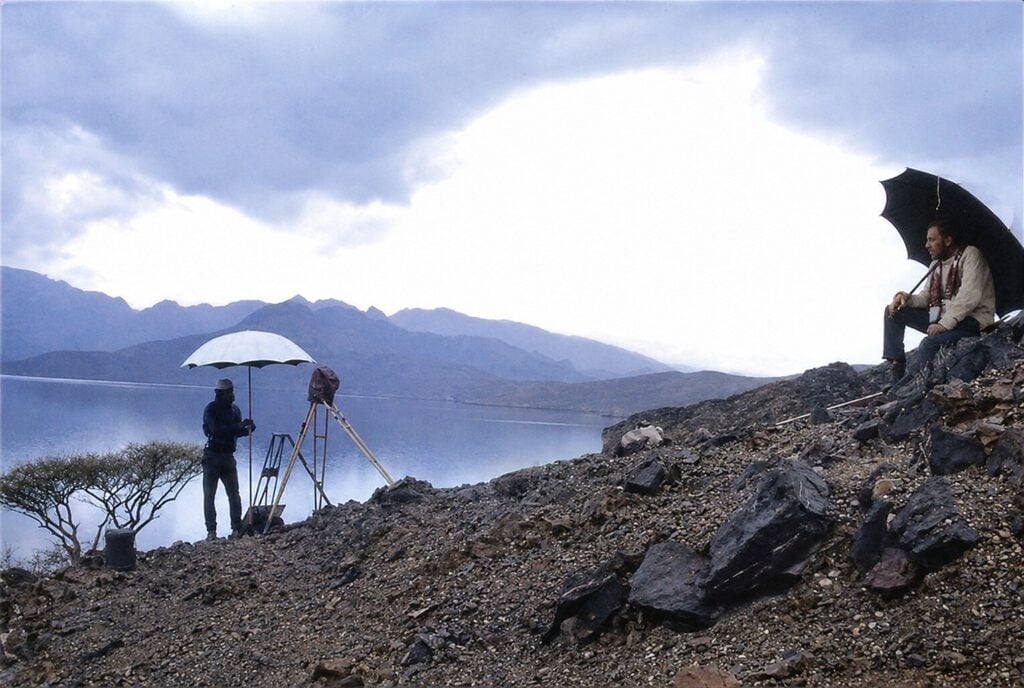
The valleys, now drowned, had probably been inhabited, the sea level then being at least 90-meters below its present level. When the ice caps began melting around 20,000 years ago, the sea rose to eventually submerge whatever settlements had stood there. The peninsula, meanwhile, was sinking steadily as the Arabian plate was pushed northwards and downwards beneath the Eurasian. One of the expedition’s objectives was to investigate these inlets for archaeological remains buried in the silt.
Norman Falcon’s work on Musandam built on his earlier pioneering geological mapping of the Zagros Mountains in Iran during the 1930s, giving him an exceptional understanding of the wider regional context. His papers established much of the tectonic framework of the region and, together with later work by others, demonstrated that the limestone sequences of the Musandam Peninsula do not continue into the Makran Mountains of Iran. Instead, Musandam forms the terminating edge of the Arabian continental margin, separated from the Makran by the major structural break known as the Oman Line.
The biological survey produced the largest and most species-rich collection of Gulf corals ever assembled, more than doubling the number of species previously recorded, along with two lizards new to science. Offshore hydrographic and geophysical surveys, together with studies of alluvial stratigraphy, indicated tilting towards the northeast during the late Quaternary. Vertical displacement off the north and east coasts appeared to have exceeded 60 meters during the last 10,000 years.
A submarine “sparker” survey attempted to define the bedrock topography of the inlets and determine the extent of their sediment infill, but steep submarine slopes made this a difficult task, and considerable rock debris in the sediment required more powerful equipment to penetrate it. The survey did identify promising locations for marine core drilling, however.
On land, the archaeological survey revealed two dozen settlement sites, the earliest dating from the 3rd century AD, and ranging from homesteads to small villages, a variety of pre-Islamic burial cairns, and a number of petroglyphs depicting armed men on horseback, animals and boats. Local inhabitants referred to “old sites” in the mountains, but it was not possible to visit them.
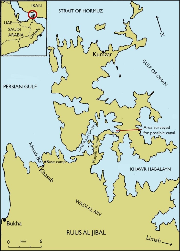
Today, closures of the Strait of Hormuz have revived talk of cutting a canal through the peninsula to link the Gulf of Oman directly with the Persian Gulf, saving vessels a round trip of some 65 kilometers. The idea is not new: the 1971 expedition’s own hydrographic survey looked into it, estimating that 1.4 million cubic meters of rock would need to be removed, at a cost of £2 million – around £26 million ($35 million) today – and a civil contractor could finish the job within two years. Given the tidal difference between the two gulfs, any such canal would need a lock.
As May remarked, “A break in the isthmus without a lock would have disastrous effects.”
His tide-cycle data was fed into the tide tables used during the Gulf War some 20 years later.
Robinson’s survey work closed a key triangulation gap, completing the last link in a chain uniting Europe and Asia Minor with Africa, a goal of surveyors for more than a hundred years. The exact distance between London and Cape Town, South Africa, was known at last.
A Farewell to Musandam
On Jan. 30, 1972, as they sailed out of Khasab Bay for the last time, a squall blew up. After sailing a short distance southwest along the coast, they saw a waterspout – a thin column of water twisting upward to meet the threatening clouds gathering overhead. Against the backdrop of an angry sky, the expedition sailed toward the calmer waters of the Persian Gulf, leaving behind a landscape that Nearchus, Alexander the Great’s admiral, had glimpsed on his return from India more than 2,000 years before.