
Oil companies have been involved in the uranium business from the onset, with geologists moving into uranium from their petroleum background, and I was no exception during my mid-career. So, this is the personal perspective of a trained petroleum explorer who had to learn quickly through working with mineral geoscientists in the field and mines.
Historically, uranium – like oil and gas – has experienced many ups and downs of activity, directly related to price fluctuations. However, the current increased importance of nuclear to the global energy mix is driving a significant interest in the exploration and mining of the mineral. The World Nuclear Association estimates uranium global reactor requirements to rise from about 68,900 metric tons of elemental uranium (tU) to more than 107,000 tU by 2040 in their Lower Scenario, 150,000 tU in the Reference Scenario. Top producing mines are expected to be depleted, and exploration will be needed to help bridge the expected gap.
Uranium is found in numerous types of deposits, but only two selected types that are representative of the largest contributing producing regions will be described. Two real-life stories of discoveries related to these deposit types offer a feel for the practices, challenges, and technologies linked to this activity from the 1950s to the ‘80s. There are a few analogies and differences between uranium exploration and oil and gas exploration. The human factor should not be forgotten, from managers to geoscientists to the sometimes-anonymous field prospectors who were essential heroes of these adventures.
Sedimentary Uranium
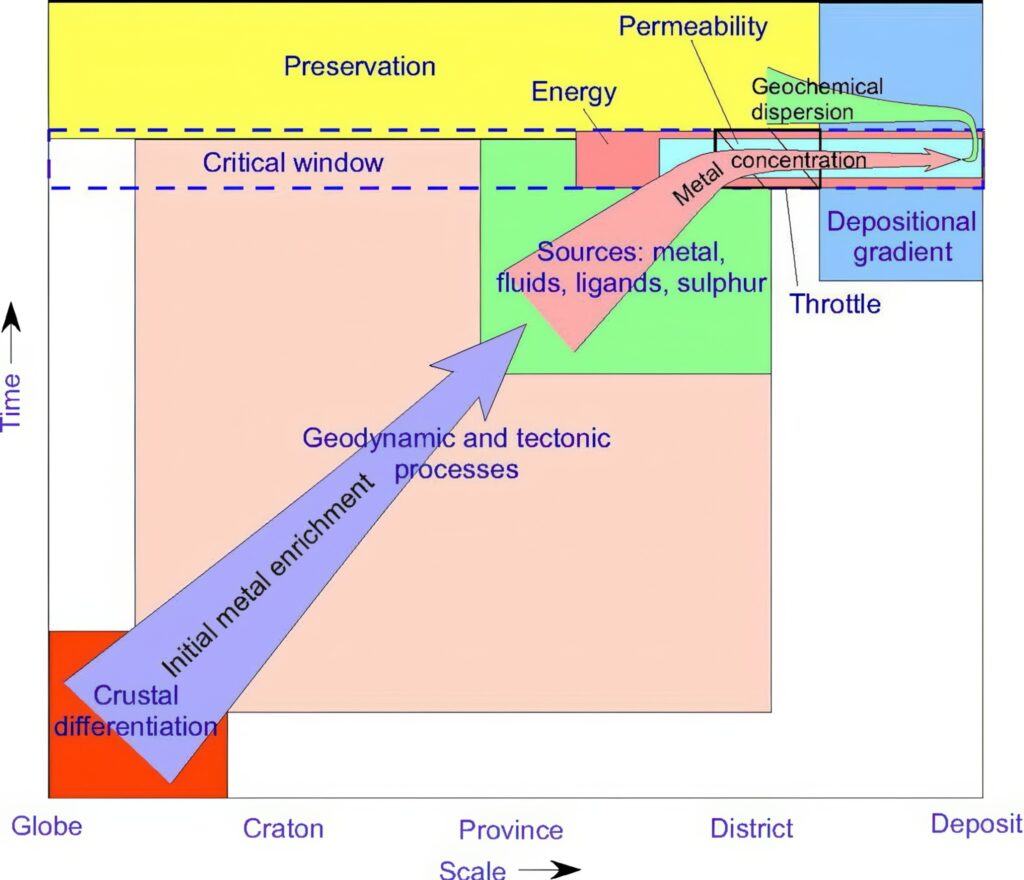
Any uranium concentration or deposit (when a concentration becomes commercial) is the result of a genetic history, starting from a regional stock of the metal – for instance, a leucogranite with an abnormally high-grade background, acid volcanics, metamorphics or magmatic intrusions in a dome or column as bedrock. It is followed by a complex sequence of physico-chemical events, a “dispersion-concentration” of leaching aquifers (meteoric or hydrothermal), leading finally to a deposit, or what could be called a “trap” in our petroleum jargon.
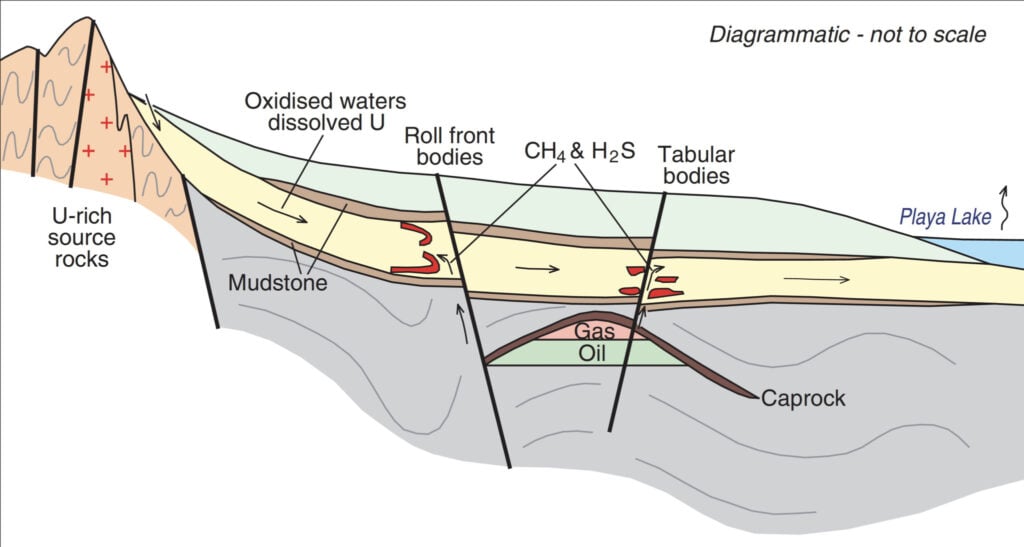
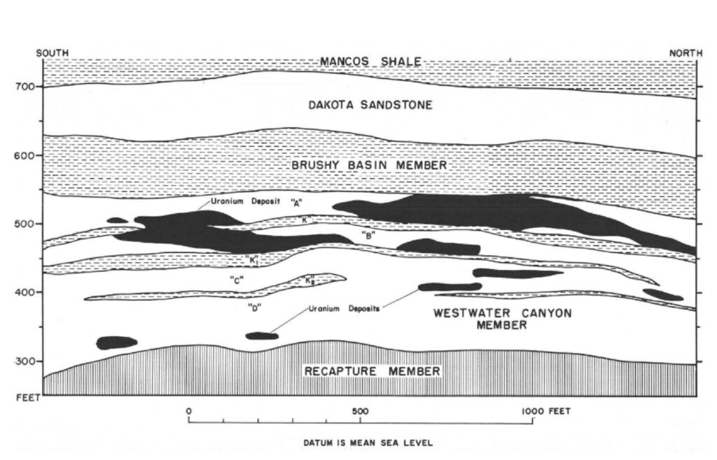
Sedimentary uranium deposits, which contain 28 percent of the world’s reasonably assured resources and 40 percent of the world’s inferred resources (WNA estimates), can be conformable or tabular, found in parallel beds of permeable sands. Another type is found in roll-fronts, created when oxidized waters carrying uranium meet reducing conditions downdip. Producing this type of deposit involves in situ leaching, which consists of leaving the ore where it is in the ground and recovering the minerals from it by dissolving them and pumping the pregnant solution to the surface into a mill which will, as in conventional mining operations (underground or open pit), treat the ore and send it as packed uranium oxide (U3O8) to other sites for power-plant fuel.
The Ambrosia Lake Story

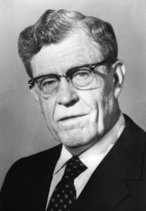
John Masters, who played a primary role in the discovery of the Ambrosia Lake deposit, told the story in his 1980 memoir, “Secret Riches: Adventures of an Unreformed Oilman.” He did that in his inimitable style, spontaneous and humorous, describing the background and complex course of events, summarized here. I am indebted to Lenora and Robert Masters for having kindly allowed me to access the book and use it.
The story begins with Stella Dysart, a colorful, commanding “whitewash of a woman,” said John Masters, who met her while in her 70s. During the 1920s and throughout the period of the Depression, she had been drawn to the area by someone who explained to her that there was a small anticline in the Ambrosia Lake area near Grants, N.M., and that anticlines should contain oil. She then bought lots of parcels there from numerous individual owners, employing crowds of salesmen, peddling them to investors and drilling many wells, all dry. Stella was, as they say, “a piece of work.”
The Grants region, located on the Colorado Plateau, was known since the ‘20s for the presence of uranium, which had been mined as a co-product of vanadium. More uranium mines were opened there after World War II to respond to the geopolitical situation and the related arms race. One of them that belonged to Kerr-McGee included the first mill to convert the mineral into U3O8. In 1955, John Masters, a 28-year-old geologist, was the company’s uranium manager, based in Denver. He stayed 20 years with Kerr-McGee before becoming a legend of the profession as president of Canadian Hunter with the discovery of Elmworth, the giant Alberta Deep Basin Gas Field.
Stella Dysart also had property in the mining areas of the Grants region, which had saved her day with comfortable royalties. She was courted by a traveling salesman named Louis Lothmann who obtained leases from her on Section 11–T14N-R10W and found a trucker named Ellis Dunn to drill wells seemingly based on pure chance (or at least mysterious, poorly understood locations). In the meantime, KMG’s nearby mill had received a set of samples of “curious” rocks for assays, and this is when Masters came in.
The mill’s manager called Masters and read him the abnormally high measured grades of uranium (some with a 1-percent grade while most numbers were in a 1/10th of 1 percent in the area). The samples came from a section of land operated by the abovementioned Dunn. John immediately flew to Albuquerque, N.M., and drove to Grants for a meeting with Dunn. Masters introduced himself in a casual way, saying that he was just passing through Grants and had heard that Dunn might have uranium on his property. They drove to Ambrosia Lake where Masters could see the samples.
He walked alone to one stack of samples with his Geiger counter and “the needle hit the end of the scale and had to be turned back to read at second then third levels, and almost every mound knocked the needle off the first stage!”
He started mapping the drill holes on an envelope he found in his pocket and quickly saw that instead of the usual 2.5-feet-thick uranium-bearing sands, this was 150-feet-thick, and the deposit was “five or ten times bigger than anything” he knew of. Masters had in fact identified the largest uranium district in the United States. He drove back to Grants and directly called the big boss Dean McGee, who reacted quickly and sent a landman in right away.
The landman passed himself off as an independent businessman and purchased section 11. He had worked for several years with KMG and fearlessly addressed the big bosses Oklahoma Senator Robert S. Kerr and Mr. McGee. In the meantime, Masters began quickly to review all the geological data available including wells in the whole area of interest. He concluded that section 10 next to 11 was still better. Thanks to his strong competitive knowledge advantage, while “a mad scramble” to stake claims was taking place, KMG started an aggressive lease-acquisition program and ended up owning 80 percent of the whole mine, “now a 10-miles-long and 1-mile-wide feature.”
One anecdote typical of John Masters’s humorous mind is worth mentioning. Employees of a mining company founded by a former military general had jumped Kerr-McGee’s claims. The excitable Masters and their landman found a rig on the land, trashed the truck’s engine and damaged the rig. The next morning, Masters cussed out the driller “while saving his most colorful profanities for their landman.” He then called on the general, and they had a lot of hard words; the general didn’t appreciate a kid swearing at him. When Masters said, “General, when you were my age, this is just what you would have done,” the older man began to smile. He said, “Boy, I think I’m gonna like you.”
However, Masters could not avoid appearing in court, where the general’s lawyer asked him to repeat the threatening language used toward the men on the rig. Masters admitted to having “a full vocabulary, probably as many as you do, but I was told not to use them in front of ladies. Maybe you weren’t brought up that way, if you want to know what bad words I used, why don’t you just say the words you’re interested in knowing and I’ll tell you Yes or No.” The courtroom, even the judge, erupted in laughter. The lawyer then turned to the judge and said, “No further questions.”
Kerr-McGee won the case and a few months later sank the first shaft in the section they had defended in court.
According to the latest state records, the total uranium oxide produced in New Mexico, nearly all of which originated in the Grants Uranium Belt, to which the Ambrosia Lake mine was its largest contributor, was about 134,000 tU as of 2002, when most mines had closed at the end of major mining operations. For comparison, consider that the total current world annual production is about 62,000 tU. The intuition of one man, John Masters, and his bold move to directly advise Dean McGee, combined with a trusting follow-up and a massive land-acquisition strategy, ended up in the greatest uranium exploration success story in the United States at the time.
Comparison with Oil and Gas
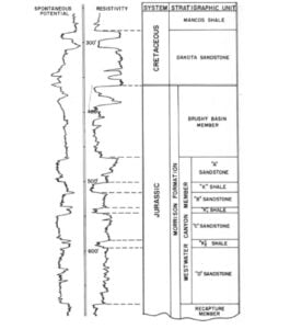
The primary focus in uranium exploration, like petroleum exploration, is on sedimentary geology (sedimentology, reservoir porosity and permeability characteristics, and thickness). As with petroleum, this is an approach based on well correlation. In the same year that John Masters made his critical move to recognize the potential size of the uranium play (1955), Petroleum Week credited the company for using petroleum geology and methods, introducing regional stratigraphy and structural mapping to integrate all data in Ambrosia Lake.
Distinct from petroleum exploration, exploration for uranium trapping is related not only to sand geometry and reservoir qualities, but also to geochemical conditions in or near the carrying rocks. Later on, it was realized that uranium ore found along and across sand bodies could be derived mostly from volcanic ashes precipitating in fluvial sandstones of the Jurassic Morrison formation, rich in carbon vegetals providing the reductants.
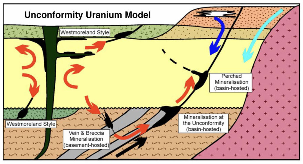
Unconformity Uranium
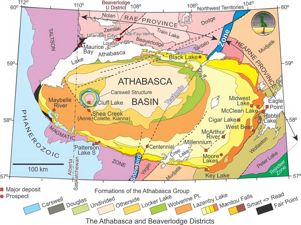
Unconformity deposits account for one-third of the uranium resources of the western world, according to WNA, and are found in rich mineralizations in Canada’s Athabasca region and Australia’s Northern Territory. They are linked in both cases to the presence of a basement bedrock rich in uranium as well as the geometry of the unconformity between the overlying Upper Proterozoic sediments (less than 1.7 billion years) and the faulted Archean-Lower Proterozoic gneiss formations (1.8 to 2.4 billion years).
Petroleum geoscientists will recognize the profile of unconformity oil and gas fields and the migration conduits from source to related traps (black arrows in the Unconformity Uranium model). Also note the graphitic reductants in the basement.
The Cluff Lake Story
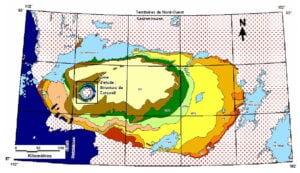
Canada’s Athabasca Basin is one of the most important uranium provinces of the world in terms of production (23.5 percent), reserves and richness (unusually high grades of several percent, are commonplace there). Uranium is found in both sediments and basement rocks near and above the unconformity, according to the model.
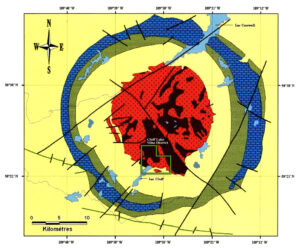
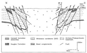
The Cluff Lake discovery was made in Saskatchewan by Amok, a joint venture between the French national company Cogema and Mokta, a subsidiary of the French resources giant Péchiney and later of Total. It took place on the edge of a prominent feature sitting in the middle of the Athabasca Basin. Cluff Lake is a superrich unconformity deposit, whose discovery resulted from a smart geological focus and a triumph of field work and technology. It is located in a perfectly circular feature, the Carswell Crater, created by the explosion of a huge meteor that hit the Earth (age debated). The geological map shows a core of Archean to Paleoproterozoic metamorphics surrounded by an aureole of intensely folded unconformable reefal dolomitic rocks and sandstones of the Athabasca Group of Middle Proterozoic age (see geological map of Carswell Crater). The basement is outcropping thanks to the elastic effect of the impact,
with an uplift in the order of 800 to 1,200 meters, according to Baudemont and Fedorowich, 1996.
The story, told by J. Dardel of the French Commissariat à l’Energie Atomique (IAEA-OECD Advisory Group, Vienna, 1979), started with an airborne scintillometer survey in 1967. More sensitive with less inertia than the Geiger counter, this process found several anomalies near Cluff Lake. It was followed by a ground reconnaissance focused near the unconformity, which led to finding pure uraninite pitchblende near a contact between the gneissic basement and sandstones of the overlying Athabasca Group. Further systematic field work in 1969 with ground and heli-borne scintillometry plus trenches and shallow drilling led to identify mineralization, mostly in fractured basement gneisses within the core of the crater.
“If the quartz leaves, it means the rock is fractured, it becomes porous and permeable so that anything available becomes transported,” said Dardel. Ore is found also in carbonaceous shales and overturned blocks at the base of the Athabasca Group and even in breccias created during the explosive event. It is remarkable that all characteristics of the unconformity model could be recognized and utilized in spite of the highly disturbed structural impact of the explosive event.
Mining properties were evaluated during subsequent drilling campaigns between 1970 and 1973. This work was made difficult by the rarity of highly dislocated outcrops and the imbrications of pre- and post-unconformity structures, as well as the overlapping Quaternary cover and explosion-related breccias elements. Half a dozen deposits were found, some of them reaching an exceptional 6-percent grade. Personnel operating on the field had to spread ample dirt on the ground before driving over mineralized sectors.
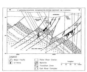
Cluff Lake produced 62 million pounds of U3O8 (23,800 tU) between 1979 and 2002. The project’s infrastructure included two underground mines, four open pit mines and a mill. It was one of several high-grade discoveries made in the Athabasca region, including McClean Lake, discovered by Minatco, a subsidiary of Total Compagnie Minière, whose mill is still treating minerals from neighboring mines, including Orano’s deep Cigar Lake mine. The concentration of mines along the transition zone between the gneissic Wollaston and Mustajic groups is explained by intrusive pegmatites (likely uranium-rich bedrock), intense faulting and graphitic content.
Source: https://science.gc.ca/site/science/en/educational-resources/history-geological-survey-canada-175-objects/43-athabasca-basin-1888.
Another Comparison with Oil and Gas
Cluff Lake was a highly successful undertaking, starting with the bright idea of focusing on a window of basement (the only such outcrop inside the basin) that was created by the explosion. The unconformity was closely explored, a remarkable feat given the structural context. The “magic tool” of scintillometry was the main driver at work, but numerous other techniques were used like false-color infra-red aerial photography, heliborne spectrometry, airborne magnetometry, very low frequency gravity, resistivity (essential for detailed fault mapping), and seismic reflection and refraction.
Petroleum geologists will recognize a familiar geometry in the relationship of mineralization to an unconformity as the leading exploration concept. Uranium was found below, against and above the unconformity, and the fault pattern served as a conduit for migrating mineral-carrying fluids from a bedrock (or source rock) to the ore bodies (or reservoirs).
However, as with the sedimentary uranium case, the mineralization is linked to geochemistry, with an organic – mostly graphitic reductant – in both gneisses and the overlying rocks. One should also note the special basement geometry of a complex fault pattern, as well as the extreme diversity of heterogeneous carrying rocks. This demanded thorough narrow-grid field work and drilling programs, unlike the generally more homogeneous reservoir characteristics for oil and gas and the (relatively) easier delineation drilling.
Current Trends and Conclusion
In the time since the period described, rising demand and geopolitical conditions have companies looking for new uncharted territories. For instance, Orano, a French national company, has started operating on a large scale in Mongolia and Uzbekistan. The main producing provinces of Kazakhstan, the largest supplier (38.6 percent of the world’s production in 2024) and Canada (23.5 percent) will continue to receive full attention. Kazakhstan boasts lengthy redox fronts (hundreds of kilometers) and new development in existing in situ leaching mines in its southern basins. Continuous discoveries are made in the Athabasca, which contains still-unexplored networks of major faults with potential related mineralization or “corridors.” The environmental constraints have led to an increase in less sensitive and more profitable ISL mining when applicable, accounting for 52 percent of the overall production in 2024, including most operations in the United States and Kazakhstan.
I have intentionally not used yet the expression “mineral system.” The concept actually came on the back of the “petroleum system” approach. It was almost unknown during my mining period (although its main ingredients were well known and at work) and has only later been gaining traction and utilized more commonly. Using “MS” systematically in a codified way must bring a common language; help quantify, combine and weigh risks of all involved rock criteria and process phases; bring a bridge to the economics; and become a profitable tool to optimize portfolio management, as is the case for oil and gas. (For details, see Descriptive Uranium Deposits and Mineral System Models published by IAEA in 2020.)
The use of “MS” for uranium (and other metals to some extent) and “PS” are strikingly comparable. Even though the geochemical conditions and the fluid physics are different – as are the involved rocks in some cases – they both involve a source-rock reservoir pair and a pattern of migration (or “plumbing”). They both take trapping into account, with a special emphasis on the timing factor, which is sometimes a true “killer’ in oil and gas. This point did not concern us much in operations at the time, as we focused mainly on the geology and the geometry of potential ore bodies.
I will leave it to younger colleagues to make a judgment on the future of uranium technical methodology. On the exploitation side, however, it is worth mentioning a new powerful ISL method implemented successfully by Orano Canada and Denison after several years of research by Orano on the McClean deposit in Athabasca (on hold since 2008). The method – surface access borehole resource extraction, or SABRE – uses hydraulic drilling with a high-pressure water and solvent jet placed at the bottom of a drill hole to excavate a mining cavity. The cuttings are then sent back by compressed air to the surface and treated in the existing mill.
On a personal note, I have enjoyed working in the mineral business, with a rather easy transition thanks to help from my friendly new colleagues. I appreciated the wide variety of rocks to deal with, the dominant role of field work, the practice of geology in its purest form, and crucial help from the truly magical tool provided by radiometrics. The business side (joint ventures, contractual issues, negotiations) was familiar, being similar to oil and gas practices. There is a challenging future for explorers in both fields, all the more so since uranium is often found together with other metals. Encouraging steps forward include a recent decision by the U.S. Geological Survey to formally include uranium into the list of critical metals and Sweden’s move to allowing mining operations there.
The greatest analogies between looking for uranium and petroleum are the love of geology and the excitement of exploration and discoveries. Mike Halbouty described the skills needed to be a good explorer to a panel of legends, including John Masters, in 2002. He added “and to say it in a vernacular – unmitigated guts!” The stories in this article would not contradict him.
A mineral system can be viewed as a sequence of geological processes that progressively concentrate metals from deep crustal origins to final deposits, with a brief “critical window” where the essential conditions align in both space and time to make mineralization possible.
Acknowledgements: Many thanks for their help to Rémy Anfray, Brian Ervin, Jean-Paul Lehmann, Lenora and Robert Masters, Chris Moore, Daniel Picard, Matt Randolph, Matthew Silverman, and Claude Valsardieu.