

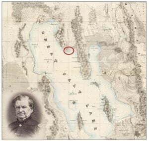
In 1849, just two years after Mormon pioneers first arrived in the Salt Lake Valley of northern Utah, Captain Howard Stansbury from the U.S. Army Corps of Topographic Engineers began his famous survey of Great Salt Lake and the surrounding areas. The main purposes of Stansbury’s expedition were to assess trails to be used by the many prospectors heading west to the newly discovered gold fields in California and to explore potential routes for a future transcontinental railroad. Stansbury encountered what he identified and documented as “petroliem,” that is, oil seeps, along the north shore of Great Salt Lake, about 16 miles south of where, 20 years later on May 10, 1869, the Union Pacific and the Central Pacific Railroads met at Promontory Summit, completing America’s first transcontinental railroad.
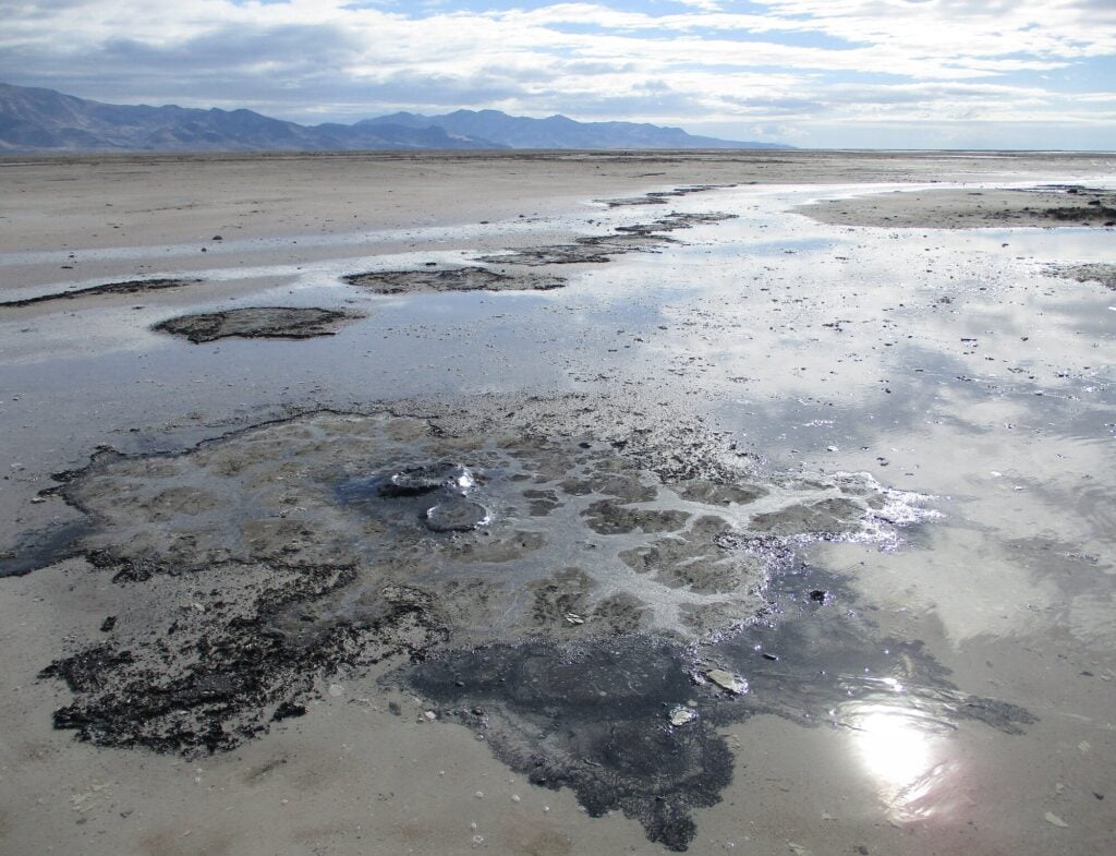
These natural, irregularly distributed oil seeps occur in an east-southeast trend over about half a mile. They become visible when the lake level drops below about 4,200 feet, appearing as small crater-like mounds or cones, 12 to 18 inches high, from which the oil issues. The seeps cover areas 20 to 40 feet in diameter and consist of thick, sticky, tar-like black asphaltic oil. The oil tends to flow in the hot summer months, leading to the demise of birds and other wildlife who occasionally get stuck in them. When the area is covered by the lake, oil issues from the sediments as small, worm-like stringers or globules.
Little did Stansbury and his comrades realize that the discovery of these oil seeps would lead to the first oil field in Utah and ultimately Amoco Production Company’s “offshore” exploration program in Great Salt Lake some 130 years later.
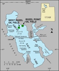
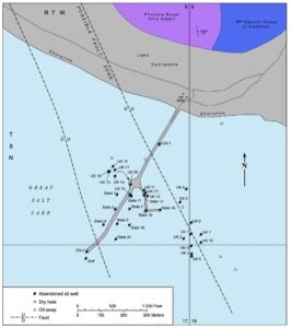
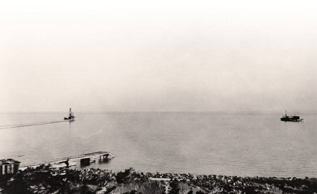
In 1904, Stansbury’s oil seeps were the impetus for the drilling and discovery of the first oil field – Rozel Point. In its early history, wells at Rozel Point were drilled on a blunt peninsula into Great Salt Lake and just offshore into its shallow waters. The reservoir was a 2- to 3-foot thick, fractured and porous Pliocene-age basalt within a small fault block combined with an unconformity, poorly sealed by unconsolidated lake mud and silt. The hydrocarbon source was probably organic-rich lacustrine sedimentary rocks of Pliocene age and the Miocene-age Salt Lake Formation. The oil migrated upward from these source beds via faults and fractures, some of which continue to the surface as the natural seeps first observed by Stansbury.
Well depths at Rozel Point field ranged from 125 to 300 feet. Initial production rates varied between 5 and 10 barrels of oil per day. An estimated 2,700 to 10,000 barrels of oil were produced from 30 to 50 wells drilled intermittently over the field’s history. The last two Rozel Point wells were drilled in 1982 by K.P. Enterprises.
The dark-brown oil produced at Rozel Point field, likely altered by bacteria, was extremely viscous and heavy, having an API gravity of 5 to 9 degrees due to a sulfur content of 13 percent. It also has anomalously high concentrations of nitrogen and asphalt. The oil was chemically similar to ichthyol, widely used as a topical anti-inflammatory, antiseptic, and antibacterial ointment. Over the years, oil from Rozel Point was used to resurface roads, for waterproofing, and impregnating the cords of automobile tire fabric prior to the introduction of latex.
Despite these various potential products, the field never proved a commercial venture. It was permanently abandoned and reclaimed in the 1990s due to the extreme adverse production conditions, very high refining costs to remove the sulfur, challenges created by rapid fluctuations in lake level, the deaths of birds and wildlife due to oil leaking from wellheads, and new environmental laws.
Amoco’s Great Salt Lake ‘Offshore’ Exploration Program
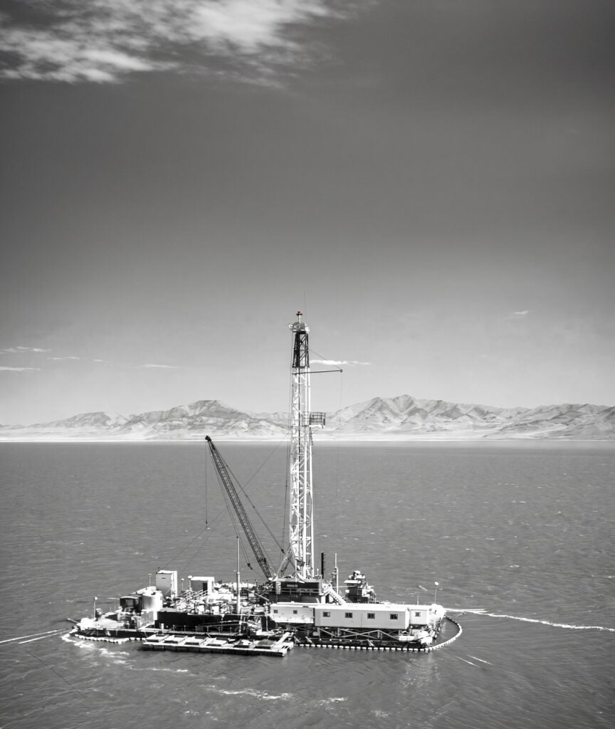
Amoco initiated their Great Salt Lake exploratory program in the early 1970s. Beneath the lake was a large untested basin in the easternmost part of the Basin and Range Province. The oil seeps and the heavy oil produced at Rozel Point field provided the proof of hydrocarbon generation in the basin. Amoco geoscientists believed that beneath the briny waters of Great Salt Lake, Basin and Range extension and resulting normal faulting had created a horst and graben system, potentially with numerous large structures, which hopefully would yield higher quality, more readily producible oil at depth than at the old Rozel Point field. After several years of geological and geophysical evaluation, one of the most unusual drilling programs in Utah and perhaps in the continental United States took place beginning in 1978 and ending in 1981 when Amoco drilled 15 wells offshore in Great Salt Lake.
Great Salt Lake
Great Salt Lake is the salty remnant of the freshwater, Pleistocene-age Lake Bonneville that covered much of western Utah and small parts of adjacent Nevada and Idaho. Great Salt Lake averages 75 miles long and 35 miles wide, covering 1,618 square miles – the 33rd largest lake in the world (and the largest fresh or saltwater lake in the United States, after the Great Lakes). During Amoco’s exploration program, the lake level was at about 4,200 feet, increasing in the spring and early summer owing to snowmelt in the nearby mountains, and decreasing in late summer and autumn. The maximum depth of the lake is about 30 feet.
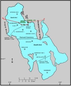
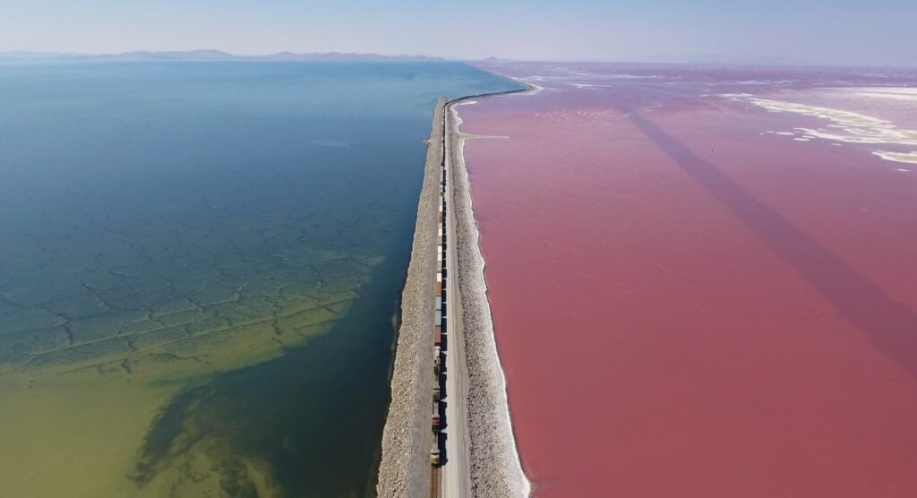
With no outlet to the sea, Great Salt Lake is famously hypersaline, losing water primarily through evaporation. From 1953 to 1959, the Southern Pacific Transportation Company constructed a gravel-filled railroad causeway (currently used by Union Pacific trains) across the lake creating north and south arms. The staging site for the causeway was centered at Little Valley Harbor near the south end of the Promontory Range. Four major rivers enter the lake but only into the south arm. With no rivers entering the north arm and only a small breach in the causeway, it has become much saltier.
The salinity of the north arm is 24 to 26 percent (near its salt-saturation point), whereas the salinity of the south arm is 12 to 14 percent. For comparison, the salinity of seawater in the world’s oceans is about 3.5 percent, while Israel/Jordan’s Dead Sea is 34-percent saline.
These unique hypersaline environments created the extremely harsh conditions that Amoco would later have to contend with during the drilling phase of their exploration program; the railroad causeway represented major logistical challenges. Amoco drilled ten wells in the north arm (two were development wells) and five in the south arm.
Geologic Evaluation, Lease Acquisition, Seismic Survey
Amoco began its Great Salt Lake exploration program with a major regional geologic evaluation of the potential petroleum system. Outcrops surrounding the lake and exposed on its six major islands range in age from Precambrian to Holocene. One of the primary drilling objectives was the Pliocene-age basalt that produced oil at Rozel Point field. Field work determined that the basalt is composed of numerous flows that probably originated from volcanic vents at Black Mountain and along the western flank of Rozel Hills both adjacent to the lake just northwest of Rozel Point. It was believed that these flows likely continued under the lake over a large area of the north arm.
Source-rock analysis of sediments from wells drilled in the north arm supported the conclusion that organic-rich Neogene sedimentary rocks, including the Salt Lake Formation, below the basalt reservoir were the most likely source for the oil from Rozel Point and the oil hopefully within traps in the north arm of the lake and elsewhere. Palynology indicated an early generation of oil during the Pliocene and Miocene, based on pollen having been exposed to heat; vitrinite reflectance showed the section was in the peak oil generation stage. The basalt flows from the Black Mountain and Rozel Hills areas may have provided the heat needed to generate oil from the underlying organic-rich, lacustrine sedimentary rocks.
Amoco also looked at the Paleozoic and Mesozoic sedimentary rocks around the lake but found only post-mature source beds.
The bottom of Great Salt Lake up to its ordinary high-water mark is owned by the State of Utah and was managed at the time of Amoco’s exploration program by the Utah State Lands Office. This ownership included the State’s mineral estates. In the early 1970s, Amoco filed for 242 hydrocarbon leases to form a massive 600,000-acre-plus lease block covering the north arm and the area west of Antelope Island in the south arm of the lake. Leases were issued by the Utah State Land Board in April 1974 with the annual rental of $1.00 per acre; Amoco had a 100-percent working interest in the leases. Besides annual rentals on the lease block, the State would receive payments in a 12.5-percent royalty from any oil produced. Permits for two exploratory wells in the south arm of the lake were granted in late 1974.
After acquiring the giant Great Salt Lake lease block, Amoco conducted an extensive 2-D reconnaissance seismic survey over the entire lake in 1973 and 1974. Ultimately the seismic data covered almost 2,400 miles. Shallow marine techniques were employed using air guns as a source at various water depths. Hydrophones were placed on the bottom of the lake at depths ranging from 6 to 18 feet. The processing of the seismic lines used a standard sequence for marine data.
The seismic program found that the western part of Great Salt Lake contains two large, previously unrecognized, Neogene basins, informally called the “North” and “South” basins, separated by a southwest-northeast-trending arch in the subsurface between Carrington and Fremont Islands. This was confirmed by later drilling.
These two basins are slightly asymmetric, deeper on the eastern flanks where they are bounded by high-angle fault zones; faulting of a lesser magnitude is also present on the western flanks. Most significantly, seismic sections revealed multiple potential drilling targets within the horst and graben systems in the basins. Traps included anticlines, faulted noses, truncated wedges, fault closures, and even stratigraphic pinchouts. Possible reservoirs in these traps were the same basalts that produced oil at Rozel Point field or deeper Miocene and Paleozoic zones. It was time to start drilling and testing these prospects.
Drilling in Great Salt Lake
Before Amoco started testing their drilling targets, they had to address the question of how to drill relatively deep wells in shallow, hypersaline waters of a huge lake. Major drilling operations in Great Salt Lake had never been attempted before and presented numerous unique problems, including no prior data, no local supply for drilling offshore, and the railroad causeway represented a barrier for “marine” crossings to the planned wells in both the north and south arms of the lake. In addition, the effects of waves and the corrosive nature of the lake-water brines on drilling operations, especially in the north arm, were unknown.
Logistics would also necessitate the use of truckable units to assemble a drill rig strong enough to withstand the harsh conditions of the lake. Furthermore, directional drilling was considered impractical because the first 2,000 to 4,000 feet of sediment was likely incompetent and unable to support a slanted hole.
Amoco used some lessons learned to overcome engineering problems during the construction of the railroad causeway in the 1950s and its maintenance thereafter. Additionally, Amoco was able to use the old Little Valley Harbor built for the causeway project as their staging area too, which they upgraded for their north arm operations. However, no facilities existed in the south arm, requiring construction of a jetty and bulkhead dock.
Before drilling began, Amoco evaluated the lake bottom to see if friction piles, a type of deep foundation that supports structural loads between soil and the pile shaft rather than resting on a hard bedrock layer, would safely hold a derrick platform. They collected wind and wave data in order to design a platform, mooring/anchoring, and the first string of conductor pipe or casing, to withstand the weather forces on the lake. Engineers studied the metallurgical and corrosion protections needed for operating in hypersaline conditions and assessed the risk of damage to platforms or pipelines in case of earthquakes (Utah is located in the Intermountain Seismic Belt). Finally, the company determined the pollution control protocols in case of accidental fuel or produced-oil spills.
Data Collection
Amoco mobilized two catamaran barges to drill 300-foot-deep core holes in both arms of the lake. They found zero-strength mud and organic ooze at the mudline, but with depth the sediments graded to normal consolidated material beginning at about 30 feet. The north arm had a layer of halite crystals.
To accurately measure waves and winds, Amoco installed two weather towers, one in each arm of the lake, which were later used by the Utah Geological Survey for a brine sampling program. Waves in the lake can vary from 1.5 to more than 5 feet in high winds and winds can reach 30 or even over 50 miles per hour in major storms. High southerly winds precede cold fronts and rapidly change to high northwesterly winds behind the fronts, along with corresponding decreases in temperatures. More wind is required to generate large waves in the heavier water of the north arm. During the course of the drilling operations, winter storms caused unforeseen ice buildups on rig equipment.
Structural Engineering
The railroad causeway required that drilling equipment would be mobilized on the north arm, then partially demobilized and trucked to the south arm, remobilized in the south arm, and finally demobilized in the south arm. A pile-supported drilling platform was a difficult option because of the very low strength of the lake bottom material and seismic concerns. A drilling structure floated into the drill site and then set on the bottom was not feasible in Great Salt Lake because no vessel of this type could be moved to the lake and the lake bottom material would not support the load.
Finally, Amoco decided that the best option was a moored floating barge, 90-by-180 feet, sufficiently strengthened to withstand the waves and winds of a 50-year storm while anchored. It could provide flexibility to drill multiple locations. The design also called for “undoing” welds and partial disassembly for the move to the south or north arms.
The drilling barge had to be held over the well with permissible horizontal motion of 1.5 feet or less. This required eight taut mooring lines laid on the lake bottom, two per corner of the barge, each 2,000 feet long made of 1.5-inch-diameter, high-strength, galvanized steel alloy wire cable with a chemical coating for short-term corrosion protection. The anchors were specially designed to hold in the salt layer and mud. Because greater motion could occur during major storms, Amoco also developed a safety disengagement procedure.
The entire mooring system, as well as the drilling barge and equipment, had to function in the highly corrosive lake water. Amoco inspected an abandoned railroad barge in the lake near the causeway and metal pieces around the old Little Valley Harbor. No adverse corrosion was detected at the waterlines leading to the conclusion that corrosion would be no worse than what would occur during relatively short duration, warm-weather marine drilling operations.
To conduct operations in Great Salt Lake, Amoco used a fleet of boats in addition to the drilling barge: two supply boats, workboats, a pollution barge, and a mud barge, which was tied to the drilling barge to catch drill cuttings that had to be taken to shore as per Environmental Protection Agency regulations. The fleet was designed to withstand corrosion problems and salt deposition.
Pollution Control
In the south arm mineral extraction is a major industry that depends on lake brines to produce magnesium metal, potassium sulfate (agricultural potash), common salt (halite), and other chemical by-products. The total annual value of these commodities in 1980 was about $137 million (or $540 million in 2026 dollars). In addition, the south arm of the lake is a major source of the tiny brine shrimp, Artemia franciscana. About 3,000 tons per year of these shrimp and their cysts or eggs were harvested in the late 1970s to feed tropical fish in home aquariums. The possibility of oil spills into the lake was a major concern for these industries.
Great Salt Lake also serves as a breeding, staging, and wintering destination for millions of migratory birds due to its immense size, dynamic water levels, diverse aquatic environments, extensive surrounding wetlands, and geographic position. Thus, Amoco’s exploration program was a major worry for the environmental community and other wildlife advocates.
Amoco diligently sought to alleviate environmental concerns and, fortunately, oil-spill control in the lake would be easier than in oceans. The wave heights are much less and currents are almost zero. The distances from shore are short, allowing for quick response times. Amoco’s pollution control equipment consisted of a floating boom encircling the drilling barge to contain accidental low-volume spills, a stored heavy floating boom to contain large oil spills outside the drilling barge boom, an oil recovery system on the pollution barge composed of a 600-foot loop of material that would absorb oil and wring it out after being pulled to the barge, and absorbent material and equipment to remove oil along the lakeshore. No significant oil spills occurred.
Stay tuned! Part two of this article next month will reveal the drilling results of Amoco’s “offshore” exploration in Great Salt Lake.