
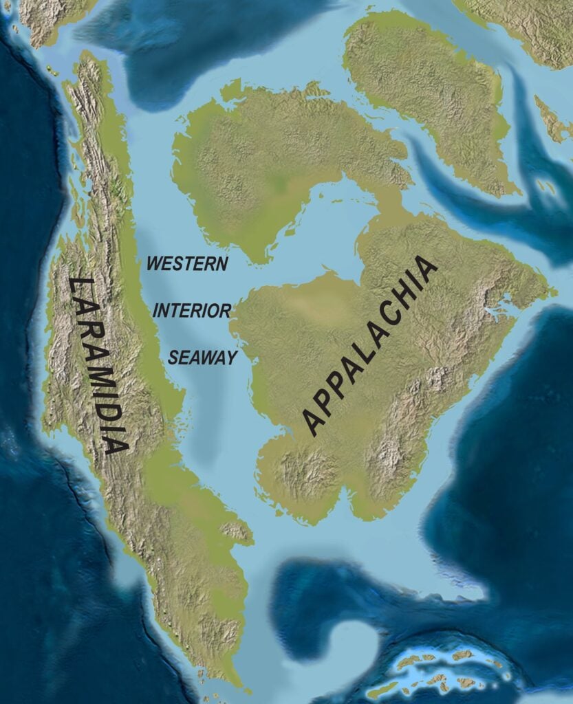
Last month, I flew from Salt Lake City, Utah to Pittsburgh, Pa. As our plane flew over Wyoming, South Dakota, Nebraska, and Iowa, I imagined that some 80 million years ago, our flight would have been above a wide sea, as all these states were underwater back then.
During the Albian to Maastrichtian times (113 to 66 Ma), a seaway separated the West Coast of America – dominated by the Sierra Nevada, Cascade, and Rocky mountain ranges – from Eastern America, which was dominated by the Appalachians. This Western Interior Seaway is a rich source of coal, oil, and gas, as well as rock record for unraveling Earth’s history and life in the Cretaceous.
New studies shed light on this amazing seaway.
Discovery of WIS
In the 19th century, geologists found Cretaceous-age marine fossils and sedimentary rocks in a broad region from the Northwest Territories in Canada as far south as Texas in the United States. These data revealed a Cretaceous seaway that ran for 5,000 kilometers and connected what is now the Arctic Ocean to the Gulf of Mexico (America). The WIS was not really an ocean with basaltic crust, but a wide shallow sea, rarely deeper than 200 meters, developed on the continental crust of North America.
In Oceans of Kansas, published in 2005, paleontologist Michael Everhart documented the natural history and fossil record of this Cretaceous seaway.
New Mapping
As they collected and compiled stratigraphic and paleontological data, geologists began to construct the paleogeographic maps of North America. Two pioneers in this field were Bailey Willis (1857–1949) and Charles Schuchert (1858–1942), who published their maps in 1909. Since then, geologists have continued updating these maps.
The latest effort is by Jonathan Shueth, Anton Wroblewski, and Keith Minor, who published their work in July in the AAPG Bulletin. The researchers consulted nearly 100 publications and produced geological maps of The WIS for Oxfordian (160 Ma), Cenomanian (99 Ma), Turonian (93 Ma), Coniacian (87 Ma), Campanian (83 Ma), Maastrichtian (70 Ma), and Danian (63 Ma) times.
These maps depict the Cretaceous distribution of sediments in the WIS onshore related to marine regression and transgressions and reinforce our knowledge of conventional and unconventional oil and gas plays.
- The conventional (migrated oil) reservoirs include the Frontier, Dakota, Codell, Mesaverde, and Lance sandstone formations in the Rocky Mountain basins and Texas’ Austin Chalk.
- The unconventional (self-sourced) shale plays include the Mowry, Niobrara, Mancos, and Lewis shales in Colorado, Utah, and Wyoming, and the Eagle Ford shale in Texas.
These researchers suggest that the best approach to map the geology of the WIS is not to focus on a formation name but on the geologic epoch during which sediments of various facies were deposited. This approach is a process-based sedimentology, rather than the name game with stratigraphic nomenclature.
How WIS Formed and Vanished
During Late Jurassic to Paleocene times, the western portion of North America was the focus of an oceanic subduction on the Pacific side. The Farallon oceanic plate subducted beneath the North American continental plate. This subduction led to the formation of the Sierra Nevada-Cascadian magmatic arc, as well as the uplift of the Rocky Mountains. As these mountains rose due to overthrust loads, the adjacent old and cold continental crust of North America bent downward – a process called “flexural subsidence.” Moreover, subduction of the Farallon Plate and its movement through the hot viscous mantle caused a downward pull in the mantle convection beneath the Western Interior crust – a process called “dynamic subsidence.”
Aside from tectonics, during the Cretaceous, the breakup of the Gondwana supercontinent and associated volcanic eruptions caused severe global warming and rises in sea level worldwide.
When the global warming period subsided, sea levels dropped drastically, and basement uplifts in the Rocky Mountains during the Laramide Orogeny intensified. Thus, the WIS vanished.
Unconformity Surfaces
In his 1983 paper, Robert Weimer described nine major unconformity surfaces in the sedimentary succession of the WIS from 112 to 66 Ma. The unconformities represent times of non-deposition and subaqueous erosion, as well as sea regression-transgression cycles. It is important to understand to what extent tectonic movements or climate changes were involved in these unconformities.
In a recent study reported in the GSA Bulletin, Nicolas Randazzo and colleagues investigated the sequence stratigraphy of five Turonian-age formations across the WIS and concluded that tens of meters of sea level rise during the Turonian was driven mostly by global climate changes rather than local causes. These researchers also suggested that the symmetry and cyclicity of the Turonian eustatic changes match Milankovitch cycles.
Ocean Anoxic Event
The OAE at the Cenomanian-Turonian boundary (94 Ma), OAE2, was responsible for the deposition of marine organic-rich mudstone in the WIS. In a recent paper in Sedimentology, Sara Biddle and Murray Gingras have detailed the evolution of OAE2 in the Canada’s Alberta Basin using sedimentological, geochemical, and ichnological data. Similar detailed studies in other basins of the WIS help better understand the sedimentary facies and hydrocarbon quality of OAE2 mudstones.
The Cretaceous period, from 145 to 66 million years ago, accounts for only 15 percent of the Phanerozoic eon. However, 35 percent of the world’s oil and gas was generated by source rocks of Cretaceous age, and about two thirds of the world’s oil and gas fields contain Cretaceous reservoirs. The WIS is North America’s Cretaceous inheritance and deserves detailed geological studies.