
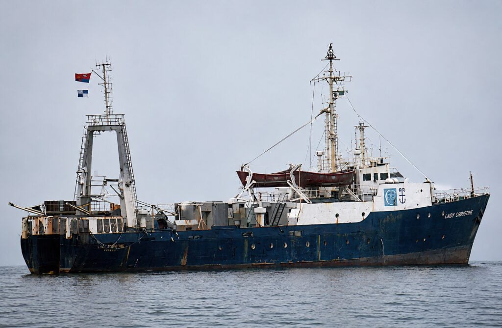
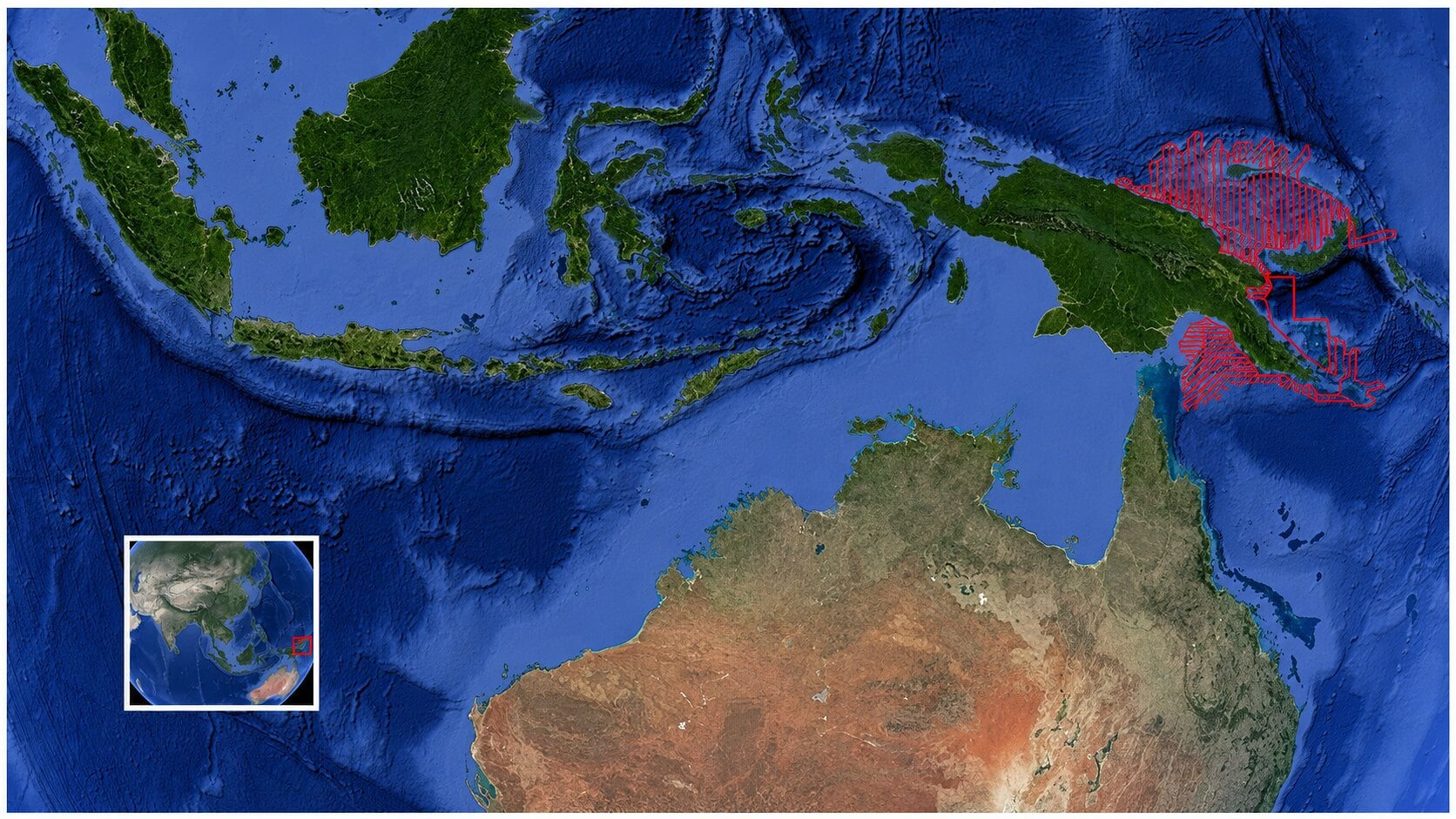
In 1970, a regional seismic survey was acquired across the Bismarck Sea offshore northern Papua New Guinea. More than 33,000 kilometers of seismic profiles were recorded during the BMR-5 survey as part of a major scientific cruise undertaken by Australia’s Bureau of Mineral Resources. For decades, the data was safely archived, but effectively inaccessible. More than 50 years later, the original recordings on analogue magnetic tapes still existed, but the machines needed to read them had largely disappeared.
The recovery of that data is a technical and historical detective story involving archived tapes, forgotten hardware and the efforts of a small group of geoscientists determined to bring an important regional dataset back to life.
A Regional Survey of the Bismarck Sea
The Bismarck Sea lies in the southwest Pacific between the northern coast of New Guinea and the islands of the Bismarck Archipelago, including New Britain, New Ireland and Manus Island. The region occupies a complex tectonic boundary between the Indo-Australian and Pacific plates and contains a mosaic of smaller interacting plates and microplates. Subduction, volcanism, back-arc spreading and strike-slip deformation all contribute to an exceptionally dynamic geological setting.
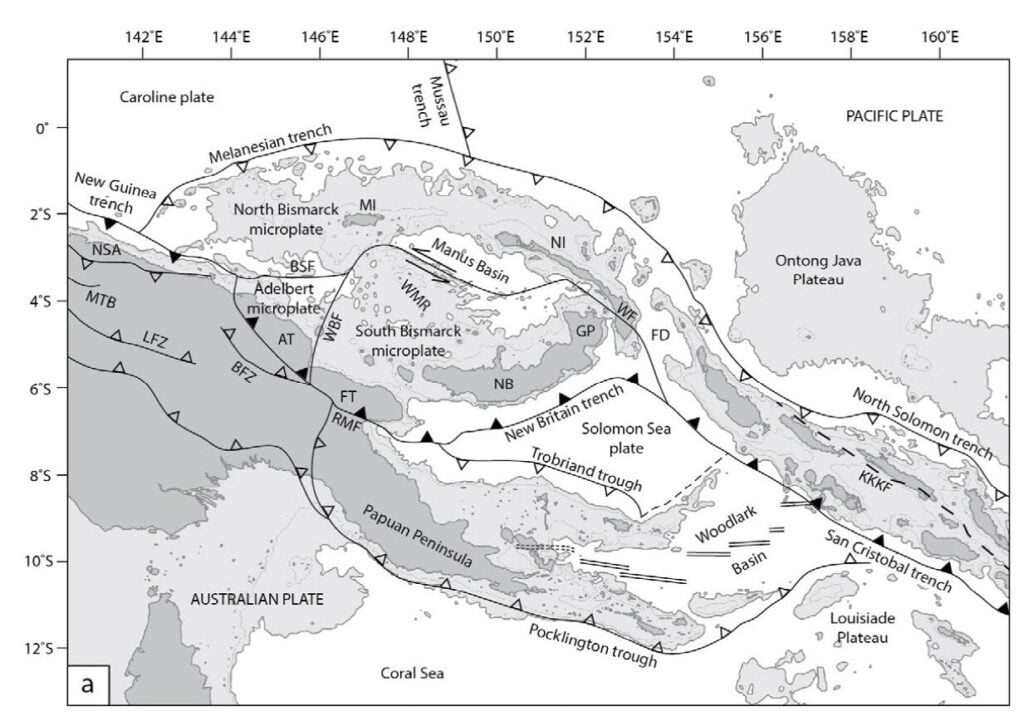
In 1970, the BMR undertook a major geophysical survey across this region as part of a broader scientific cruise that also collected bathymetric, gravity and magnetic data. The seismic survey was acquired using the Compagnie Générale de Géophysique vessel M.V. Hamme, later renamed M.V. Lady Christine. Between September and December of that year, the vessel recorded more than 33,000 kilometers of regional seismic lines across the Bismarck Sea and adjacent areas.
The seismic system consisted of a six-channel streamer approximately 1,000 meters long with receiver groups at 200-meter spacing, supplemented by a single-channel high-resolution cable. The energy source was a sparker array consisting of four 30,000-joule Geotech units fired at approximately 50-meter shot-point intervals. While modest by modern standards, this system represented state-of-the-art marine seismic technology for its time.
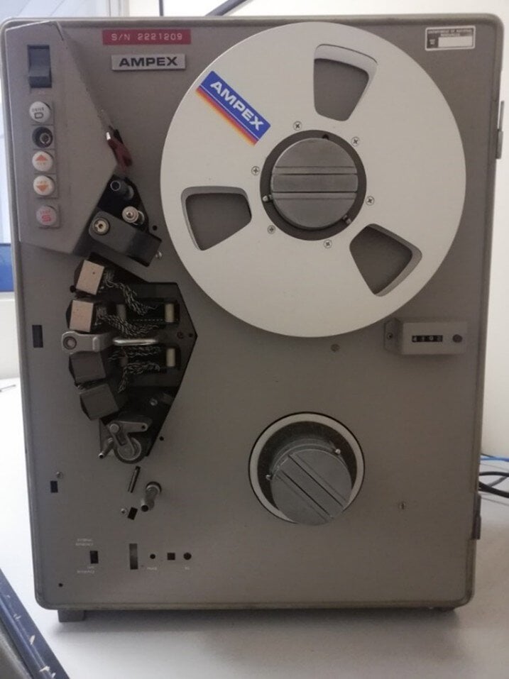
During acquisition, the shipboard scientists monitored the data using paper chart recorders and other graphic recording systems that produced continuous seismic sections for immediate interpretation. At the same time, the signals were recorded onto magnetic analogue tape using a 14-channel AMPEX FR-1300 analogue recorder. These tapes served as the archival record of the survey.
Over time, the paper monitor records degraded, and the specialized tape recording equipment became obsolete. Although the tapes were carefully archived by what is now Geoscience Australia, the data themselves could no longer be easily accessed.
A Forgotten Dataset
I first encountered the BMR-5 survey in 2015 at an AAPG conference in Melbourne, Australia. There I met geophysicist Mike Swift, who had been attempting to work with the data for some time. Mike explained that the seismic tapes still existed but were recorded in AMPEX analogue format and could not easily be read with modern equipment.
He had managed to transcribe one line using specialized equipment, but the resulting data proved difficult to process and interpret. He provided me with some of the available files and documentation to see whether further progress might be possible.
At the time the project seemed challenging. The Bismarck Sea remains an area of complex geology with limited seismic coverage, and the BMR-5 dataset represented the only regional seismic survey across large parts of the basin. If the tapes could be recovered, the data could provide valuable geological context for understanding this frontier region.
However, accessing the data required solving a fundamental problem: how to read analogue tapes recorded nearly 50 years ago using hardware that was no longer manufactured.
Early Attempts
Initial attempts focused on working with the limited digital data that had already been transcribed. The files were provided to Zebra Data Processing in an attempt to generate usable seismic sections. Unfortunately, these efforts were unsuccessful.
Only later did we realize that the earlier transcription contained subtle errors in the analogue-to-digital conversion process that made processing the data extremely difficult.
Another idea was to reconstruct the seismic sections from the scanned shipboard monitor records. Together with Andy Livesey at PT Horizon, we explored the possibility of vectorizing the scanned paper records and rebuilding the seismic traces digitally.
In principle, this approach might have worked. In practice, however, many of the original plots had deteriorated, and the scanned images were often of insufficient quality. Furthermore, the display format – variable area without wiggle traces – made automated digitization difficult.
By this stage it was clear that the only reliable solution was to recover the original data directly from the analogue tapes.
The Search for the Hardware
In 2019 I returned to Perth after several years working in Singapore. Soon afterward I met with an old friend and colleague, Keith Woollard. I described the Bismarck Sea project and the challenges of accessing the archived tapes.
Keith is an expert in digital systems and data recovery, and we quickly realized that if the tapes could once again be played on a compatible AMPEX drive, it might be possible to digitize the analogue signals using modern hardware.
The question was whether any functioning AMPEX equipment still existed.
Through contacts in the seismic industry, we eventually discovered that Roy Whitworth, a former BMR scientist, had preserved several AMPEX tape drives and spare components after retiring from the Australian Geological Survey Organisation, the successor to BMR and predecessor of today’s Geoscience Australia.
Roy had the foresight to retain this equipment rather than allowing it to be discarded. When we contacted him about the project, he generously agreed to provide the drives and associated hardware.
At the time, the equipment was stored at the back of a storage shed filled with furniture, so it took some time before it could be retrieved. While waiting, Keith and I familiarized ourselves with the available survey documentation – reports, navigation records, maps and observer logs available through Geoscience Australia’s National Offshore Petroleum Information Management System database.
Eventually the equipment was shipped to Keith’s GeoCom office in Perth, where he and Graeme Murray began the painstaking process of restoring the drives and designing a system capable of digitizing the tape output.
Rebuilding the System
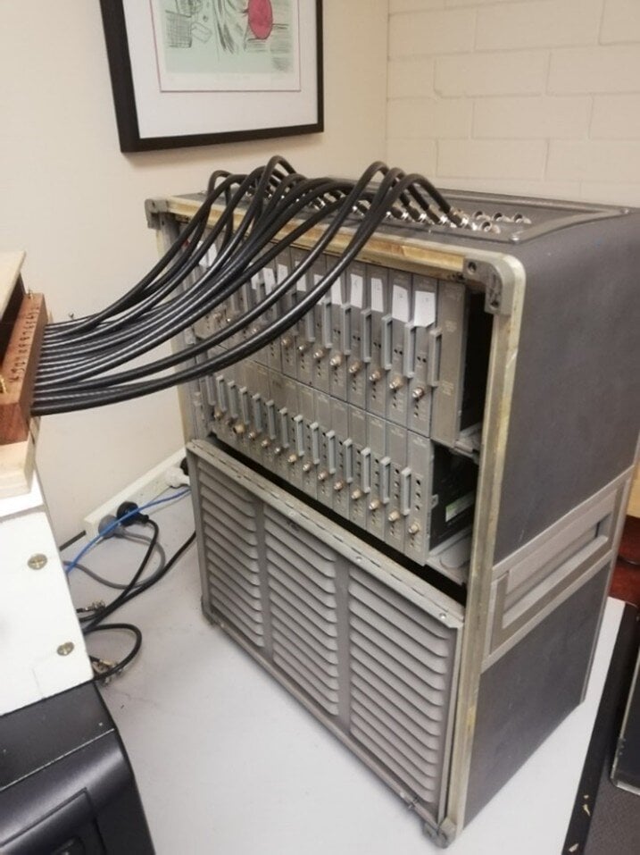
The AMPEX FR-1300 recorder outputs fourteen analogue channels through bayonet-type connectors, each representing one recorded data track. Earlier attempts to transcribe the tapes had involved connecting the drives to older seismic processing systems such as DFS-III field processors.
We decided to take a simpler approach.
Instead of relying on outdated processing hardware, the restored tape drive would be connected directly to a modern computer using an analogue-to-digital conversion system. A small interface box was constructed to connect the 14 output channels to a multichannel A-D card installed in a standard personal computer.
Keith and Graeme wrote custom software to record the incoming signals as the tape was played back. Each channel was written as a continuous stream of sampled voltages into a text-based data file.
A typical field tape contains around nine hours of recording and produces tens of millions of samples per channel. This raw output can be considered a direct digital transcription of the analogue tape. However, it is not yet organized into seismic shot records. The data simply consist of long streams of recorded voltages for each channel.
Reading the Tapes
Working with analogue seismic tapes presents several unusual challenges. Unlike modern digital recordings, analogue data streams contain no internal markers, file boundaries or record numbers. Determining where individual shots begin and end requires interpreting timing signals recorded on additional channels.
Fortunately, the BMR recording system included several timing references. One channel recorded the sparker firing signal, producing a spike for each shot. Other channels encoded periodic timing markers, including alternating voltage patterns every eight and ten minutes, as well as a constant 100-hertz reference signal.
By combining these signals with information recorded on the original tape labels – including the start and end time of each tape – it became possible to reconstruct the timing of the seismic records.
Software was developed to process the continuous data streams, identify the shot signals and segment the recordings into individual traces. These could then be assembled into a standard SEG-Y format suitable for seismic processing.
Because analogue recordings sometimes include gaps – when operators stopped recording temporarily – several iterations were often required to ensure correct shot numbering and alignment. Observer logs and shipboard notes proved useful in identifying these interruptions.
A First Test
Before attempting to read the Bismarck Sea tapes, we requested three field tapes from Geoscience Australia as test material. For safety, we selected a line from the Gulf of Papua portion of the survey, where modern seismic data already exist. This allowed us to test the transcription system without risking the only available records from the Bismarck Sea.
Working with 50-year-old magnetic tapes requires caution. Cleaning procedures, playback speeds, and sampling rates all had to be carefully adjusted to ensure stable readings.
One advantage of analogue recordings is that playback speed can be varied without degrading the data, provided the electronics can keep up. After testing, we found that the tapes could be read at several times the original recording speed and sampled at millisecond-level resolution without loss of information.
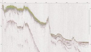
With growing confidence, we then requested a long south-north seismic line from the Bismarck Sea portion of the survey. The successful transcription of this line demonstrated that the archive tapes can indeed be recovered.
Geological Context
The BMR-5 survey covers a region of exceptionally complex tectonics along the northern margin of the Australian plate. Here the Indo-Australian plate interacts with the Pacific plate and several smaller microplates within a dynamic zone of subduction, collision and back-arc extension.
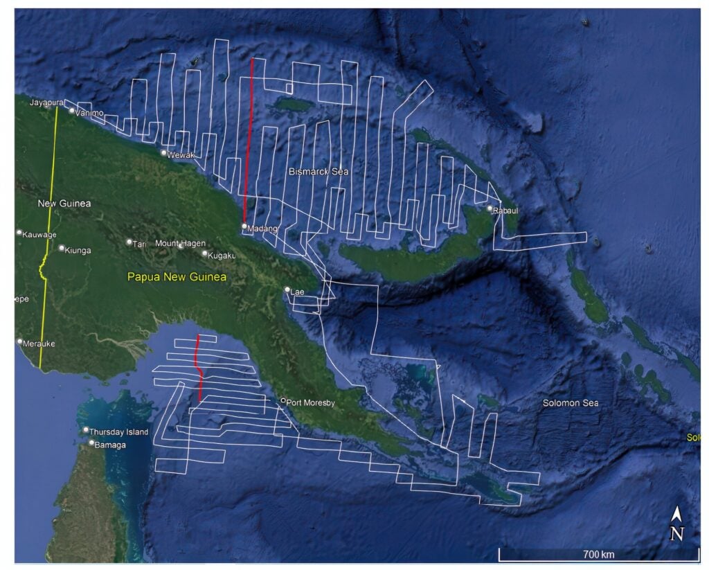
The Solomon Sea Basin to the south is associated with subduction beneath the New Britain arc, while the Bismarck Sea includes active back-arc basins formed behind the volcanic arc system of New Britain and New Ireland.
Subduction along the New Britain Trench – reaching depths greater than 8,000 meters – drives intense volcanism and crustal deformation throughout the region. Chains of volcanoes, active hydrothermal systems and complex structural patterns are characteristic of this tectonic environment.
Uplift of the Papua New Guinea orogenic belt during the late Miocene and Pliocene resulted in significant erosion and sediment transport into offshore basins. Major river systems, including the Sepik River, deliver enormous volumes of sediment to the surrounding marine basins.
Only a small fraction of this sediment accumulates on the continental shelf and slope. Much of it is transported offshore through gravity flows into deeper basins, potentially forming turbidite systems that may serve as reservoirs.
Similar sedimentary systems in other regions, such as the Mahakam Basin of eastern Borneo, have proven capable of generating significant hydrocarbon accumulations.
What the Data Might Yet Reveal
At present, only a single seismic line from the Bismarck Sea BMR-5 survey has been successfully transcribed and converted into modern digital format. As a result, it is premature to draw firm conclusions about basin architecture, stratigraphy or petroleum systems across the Bismarck Sea as a whole.
However, the successful recovery of this test line demonstrates that the analogue tapes can be read and converted using the restored recording equipment and modern analogue-to-digital conversion techniques.
The remaining archive therefore represents a potentially valuable regional seismic dataset. With sufficient support, the full suite of BMR-5 tapes could be recovered and processed, providing basin-scale seismic coverage across large parts of the Bismarck Sea where modern data remain sparse.
Such information could help clarify structural trends, sedimentary systems and the overall geological framework of this frontier basin.
The limited petroleum exploration activity that followed the BMR-5 survey is generally related to the longstanding perception that much of the Bismarck Sea is underlain by oceanic crust, with only limited development of continental shelf or continental crustal elements. However, this interpretation has historically been based on relatively sparse regional geophysical data, and large parts of the basin remain poorly imaged by modern standards.
In contrast, the region attracted considerable interest in deep-sea mineral exploration, particularly volcanogenic massive sulfide systems associated with active hydrothermal activity, culminating in projects such as the now-defunct Solwara-1 development offshore Papua New Guinea. Despite the prevailing oceanic crust model, the broader tectonic complexity of the region and the limited availability of modern regional seismic data mean that aspects of the basin evolution and sedimentary architecture remain incompletely understood.
A Legacy Dataset Rediscovered
The recovery of the BMR-5 tapes illustrates how historical geophysical surveys can still yield valuable geological information decades after their acquisition. Although the technology used to record the data might become obsolete, the underlying information remains preserved in the archive.
Bringing these datasets back to life requires not only modern digital tools but also a degree of historical detective work – locating forgotten hardware, reconstructing recording systems and understanding how the original data were acquired.
The BMR-5 survey is a reminder that the archives of past exploration campaigns might still contain untapped geological insights.
Acknowledgements
The author gratefully acknowledges the contributions of Keith Woollard and Graeme Murray, whose expertise in digital systems and electronics made the restoration of the AMPEX tape drives and the transcription of the BMR-5 tapes possible. Thanks are also due to Roy Whitworth, who preserved the original AMPEX equipment after his retirement from the Bureau of Mineral Resources, and to Peter Baillie, who provided valuable geological insight into the regional setting of the Bismarck Sea.