
Recent years have seen a clear decline in discovered reserves, driven by reduced drilling investment and the increasing complexity of exploration. Large, simple structural traps are mostly exhausted, pushing exploration toward deeper, more geologically complex plays. This shift requires improved seismic imaging and closer interdisciplinary integration. Two examples will illustrate these themes in what follows.Exploration always carries uncertainty, whether in source, reservoir, trap, or migration, and seismic interpretation is central to assessing these uncertainties. Although quantifying uncertainty remains difficult, several practical approaches have contributed to more reliable exploration and development outcomes.
The first example shows how an independent company achieved near-field success by combining geoscience technologies with strong regional geological understanding, validating the trapping model through adaptive seismic imaging and amplitude-versus-offset analysis.
The second example, from the West Delta Deep Marine project, highlights how technology and cross-disciplinary collaboration help address
uncertainties in reservoir channel connectivity. Seismic tools were key to distinguishing multiple channel systems, reducing connectivity uncertainty, and improving infill well planning and reservoir management.
A Mid-Norway Case Study
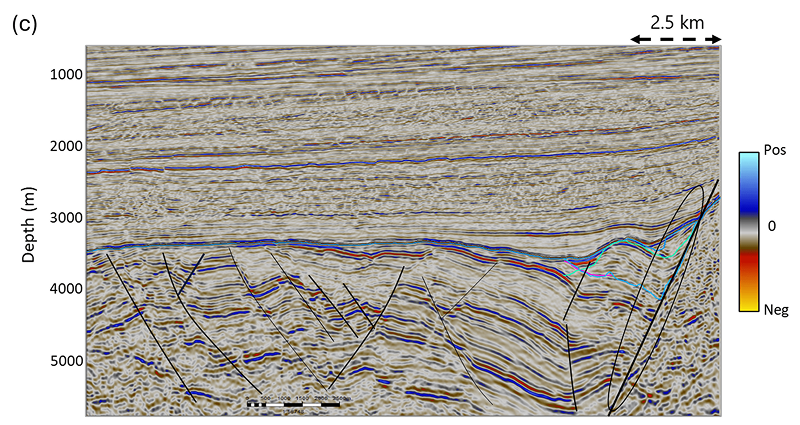
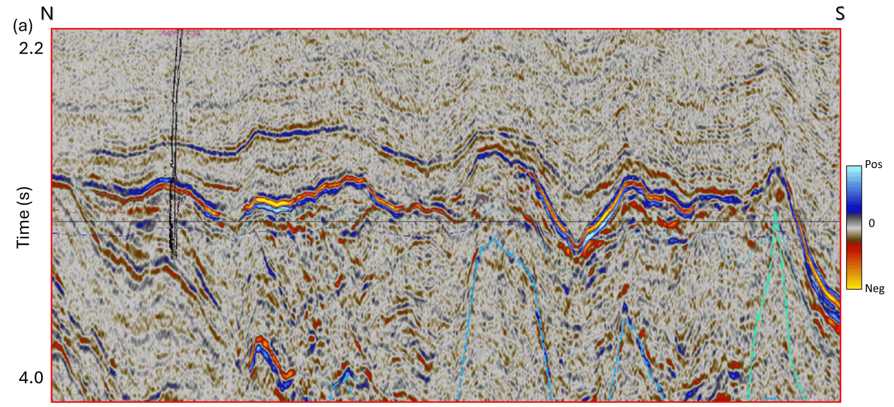
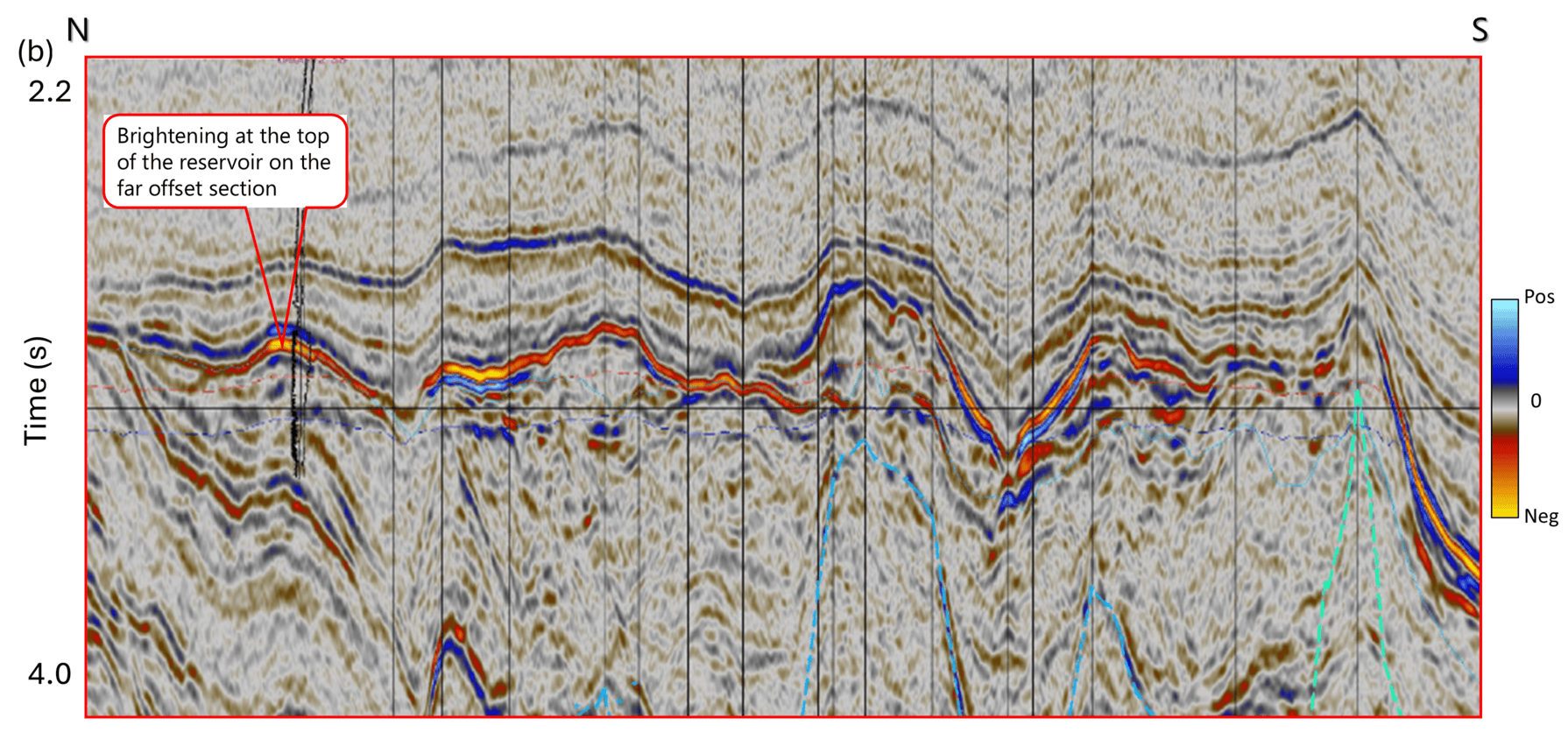
The block lies on the Halten Terrace offshore Mid-Norway. Exploration targeted Upper Jurassic syn-rift plays, focusing on prospects defined by combined structural–stratigraphic closures and clear direct hydrocarbon indicators. The main pre-drill uncertainty concerned the trapping configuration, which was refined using advanced seismic imaging (figure 1). Beam depth migration – superior to conventional Kirchhoff migration for complex, steeply dipping structures – improved fault delineation and strengthened confidence in the entrapment model. AVO analysis and fluid-factor interpretation (figure 2) provided further support for hydrocarbon presence.
Two subsequent wells targeting Upper Jurassic syn-rift prospects encountered commercial oil and gas, expanding the play to include new segments, reservoir types, and trap configurations.
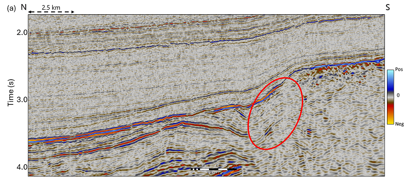
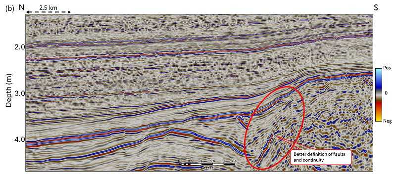
Comparison of segments of seismic sections from (a) prestack time-migrated, and (b) prestack depth-migrated (beam migration) volumes. The depth migrated data shows better definition of faults and continuity compared to the time migration. A convenient fault delineation geometry is shown on the depth-migrated zoomed section shown in figure 1c.
Notably, major operators had previously dismissed the block as non-prospective.
The eventual breakthroughs were made by small independent companies operating without large datasets or extensive organizational support. Understandably, their success stemmed from strong local geological understanding, focused application of seismic technologies, and sufficient resources to iteratively test and refine exploration concepts.
A West Delta Deep Marine Case Study
Assessing reservoir connectivity and water resources is critical for predicting performance in infill drilling. This case study from the West Delta Deep Marine field illustrates the uncertainty in estimating sand connectivity using seismic data. Seismic attributes were used to identify individual channels and their architectural elements, and these interpretations were integrated with well data to infer depositional facies and connectivity. However, production results from later infill wells revealed significant discrepancies, underscoring the limitations of relying solely on seismic interpretation.
The WDDM concession lies 50 to 100 kilometers offshore in deep water on the northwestern Nile cone, covering 6,150 square kilometers. Most gas fields are hosted within Pliocene turbidite slope-channel systems trending northeast-southwest to northwest-southeast across a gentle slope. Traps are stratigraphic at channel margins and a mix of structural and stratigraphic along channel axes. The Plio-Pleistocene reservoir architecture is well imaged on 3-D seismic (figure 3), and seismic amplitude maps help define channel evolution. Gas-bearing sands display a Class III AVO response.
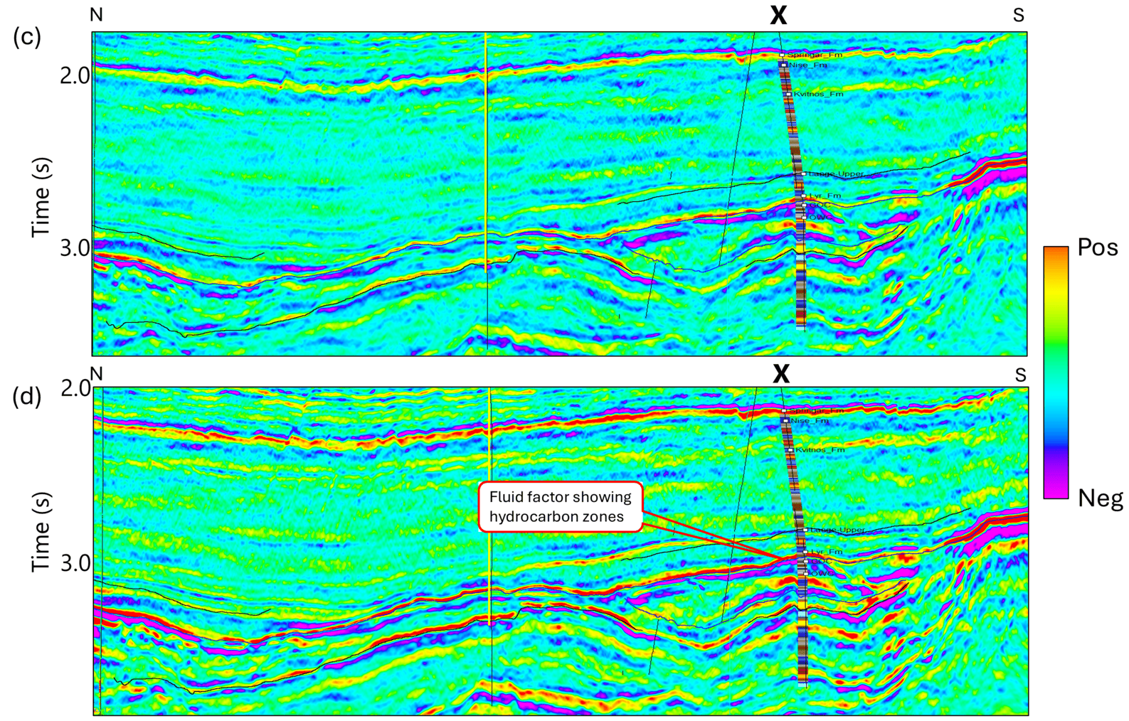
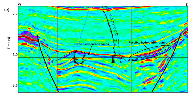
Comparison of segments of seismic sections from (a) near-offset, and (b) far-offset volumes. A brightening of the amplitude is noticed at the top of the reservoir on the far-offset section. A similar comparison segments of sections from fluid-stack volumes generated (c) before drilling of discovery well, and (d) after integrating the result of discovery well. Negative values of fluid stack have been interpreted as presence of fluid stack, which are seen prominently as indicated by the pointer text. (e) A zoomed section from a west-east fluid-stack section shows the proven and possible hydrocarbon zones.
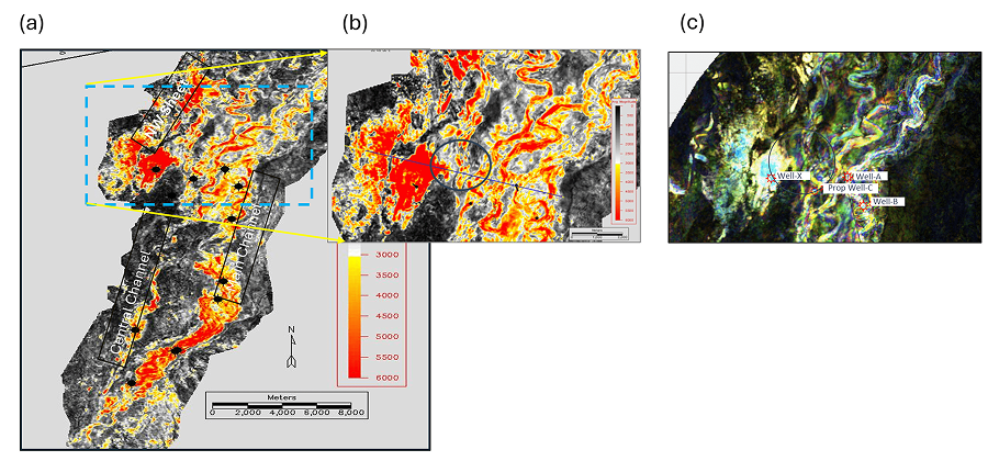
Horizon slice showing a deep-water slope channel reservoir as seen on the (a) seismic amplitude, and a zoom of a small portion of the channel is shown in (b). (c) RGB corendered spectral magnitudes generated from the spectral decomposition of the seismic data. The channel geometry is seen defined better on the RGB corendered spectral magnitude display but there was no added value in terms of uncertainty reduction.
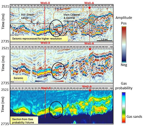
Comparison of sections passing through (reprocessed seismic data), (b) vintage seismic data, and (c) gas probability volume generated using the reprocessed seismic data. The sections pass through two wells drilled through the Northwest Sheet (Well X), and the main channel segment (Well A). The encircled area shows a possible area of connectivity of the segments. However, infill well drilled in the Northwest Sheet proved to be virtually isolated from the main channel.
The channel complex, comprising the Main Channel, Central Channel, and Northwest Sheet, forms a single canyon-fill system. Reservoirs typically include a stacked, sand-rich core belt with leveed wings. Seismic mapping suggested potential connections between these systems, particularly the Northwest Sheet and the Main Channel. Spectral decomposition and seismic inversion studies enhanced channel resolution but did not materially reduce uncertainty (figures 3 and 4). As a result, the base-case reservoir model assumed only partial connectivity and predicted pressure depletion in the Northwest Sheet.
However, when Well X was drilled in 2012, after seven years of production from Main Channel wells, it encountered virgin pressure, demonstrating that the Northwest Sheet is hydraulically isolated from the Main Channel complex (figure 5). This outcome highlights the persistent ambiguity of seismic-based connectivity predictions and the need for caution when using seismic alone to assess reservoir communication.
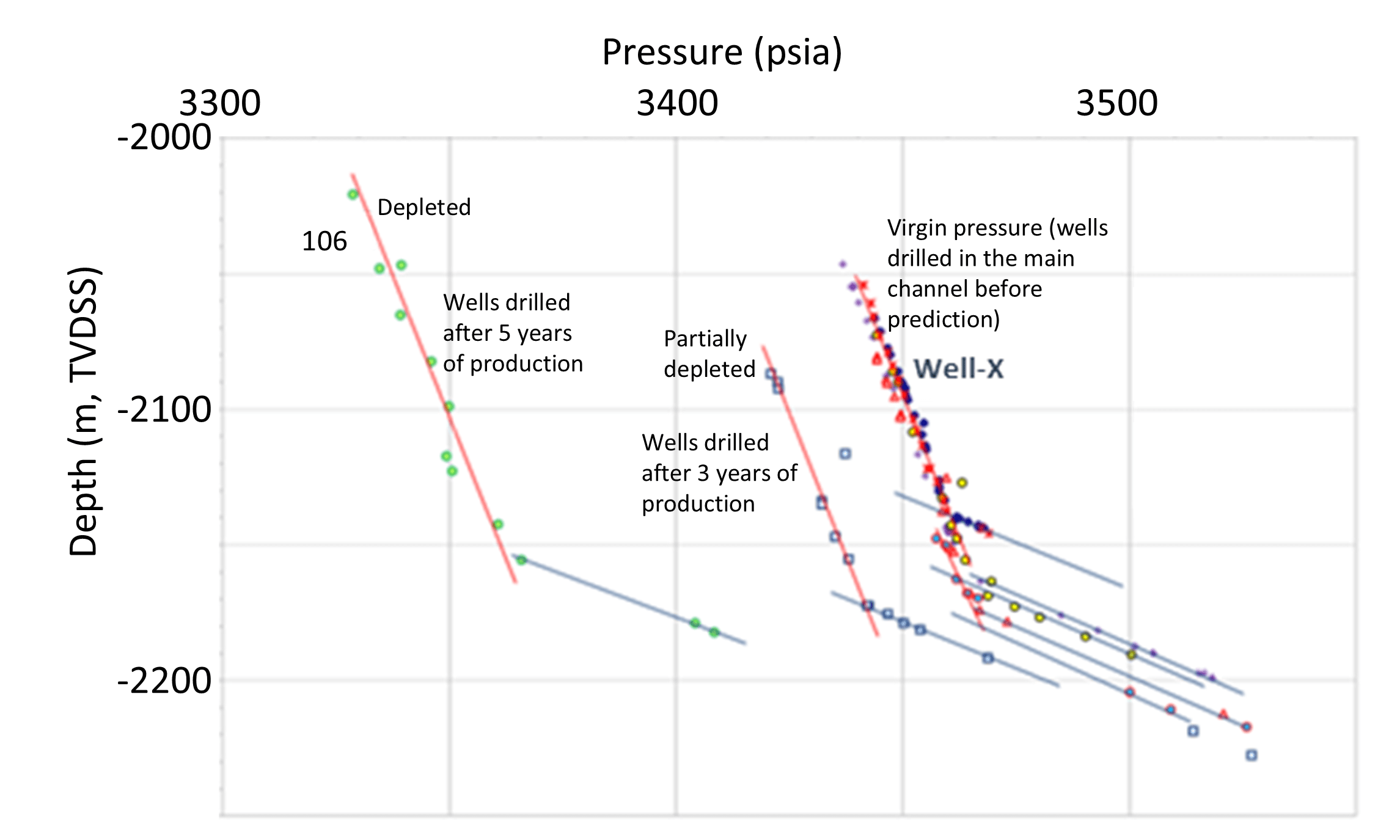
Pressure plot for different wells in the area, included the data from Well X drilled in the Northwest Sheet, hich encountered virgin pressure (undepleted) and free water level came deeper than the wells drilled in the main channel. This proved the Northwest Sheet to be virtually isolated from the main channel.
Experience with infill development in the WDDM shows that predicting reservoir connectivity across faults and areas with low-amplitude seismic response is highly uncertain. Pressure barriers and thief zones are frequently present at subseismic scales. Unless connectivity is well constrained, the preferred practice has shifted toward probabilistic methods. Connectivity between reservoir segments is now typically assessed using some advanced approach that spans scenarios from fully connected to fully isolated, with several intermediate cases. Consequently, connectivity becomes a key variable during history matching, helping achieve agreement with historical pressure behavior and/or water production rates. Forecasts of reservoir performance, including depletion patterns and well productivity, then depend on the history-matched model.
The Lessons Learned
The success story in opening a new play segment demonstrates how advanced technology, when combined with a strong understanding of both regional and local geology, can unlock new opportunities. Compartmentalization and uncertainty in reservoir connectivity remain major
challenges throughout a field’s life and are especially critical for infill development. The second case study reinforces that evaluating a broad range of geological models and fostering collaboration across disciplines are essential for reducing uncertainty and improving reservoir characterization.
As the industry moves into increasingly challenging environments, such as deepwater settings, geologically complex basins, and areas with significant stratigraphic variability, a dual strategy is required. This strategy pairs geoscience-driven technological innovation with strong interdisciplinary collaboration and communication.