
Hell, Grand Cayman
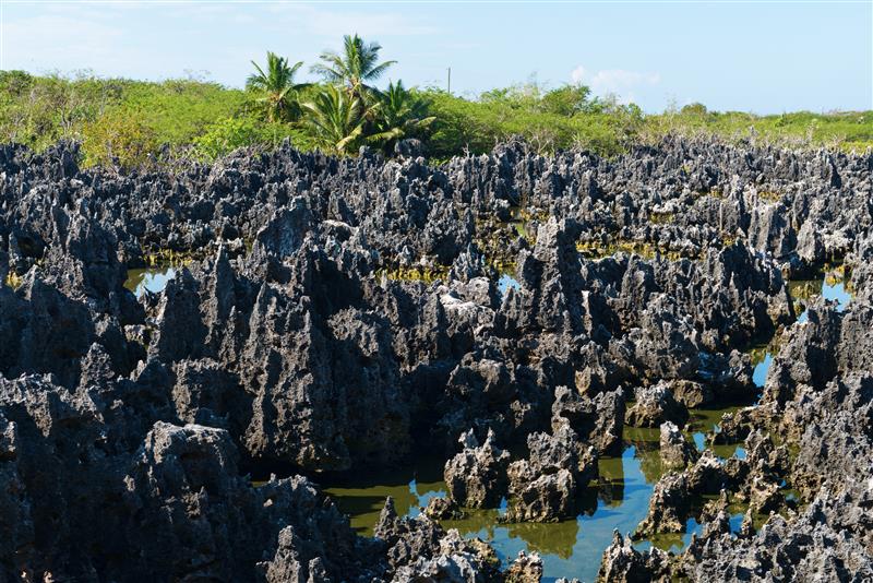
I can safely say I’ve been to Hell and back again. I’ve even mailed a postcard from there.
- The black, sculpted, jagged, pinnacle-like limestone spires of Hell, are found in West Bay, Grand Cayman.
- The limestone, part of the Pleistocene Ironshore Formation, has a characteristic phytokarst surface, the result of bacteria, fungi, and cyanobacteria actively sculpting its unique topography. The microbes excrete acid as they bore into the rock.
- Beneath Hell’s black, craggy surface, the limestone is gray.
- The Pleistocene limestones were deposited on top of a gradually subsiding core of Oligocene and Miocene limestones.
One fun thing: This site is the only place (that I know of) where you’re greeted with “How the Hell are you?” when you enter the post office.
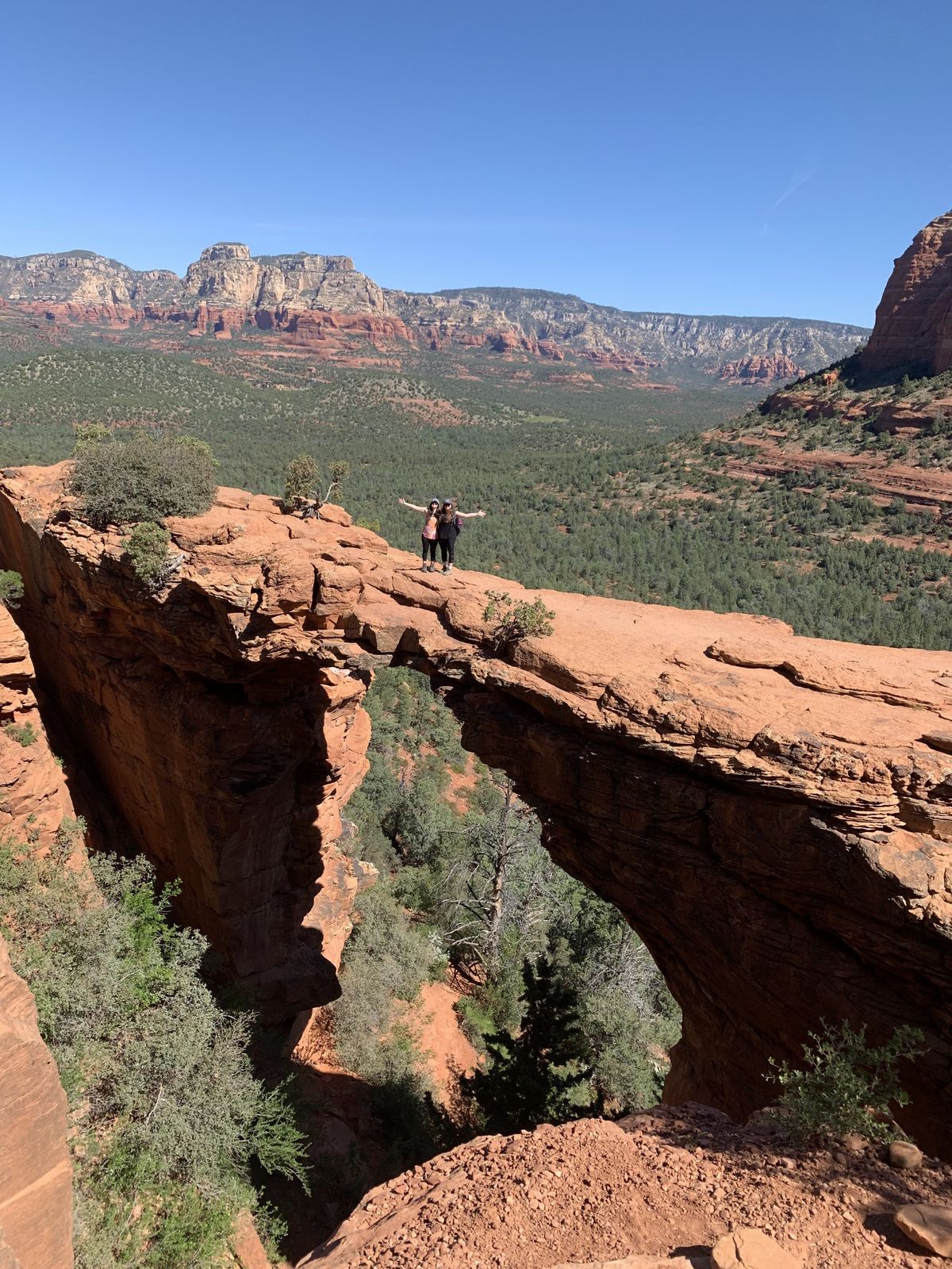
Devil’s Bridge, Sedona, Arizona
There are so many geologic features named for the devil; it’s downright scary! Devil’s Tower National Monument and Devil’s Postpile National Monument come immediately to mind, but there’s also Devil’s Backbone, Devil’s Windpipe, Devil’s Playground, and Devil’s Garden. An extensive list with descriptions can be found here.
My daughter, Marie Thomas, recently visited Devil’s Bridge, a narrow, wind-eroded arch and popular hiking destination located north of Sedona, Arizona. Here’s a little about its geology:
- In the Permian, along the shoreline of the Supercontinent of Pangea, the region was covered with layers of muds and sands from slow-moving rivers across vast floodplains. The sediments would later become the Hermit Formation, Sedona’s brick-red bedrock.
- The area continued to experience deposition, adding more than 200 meters of colorful sandstone interspersed with thin white layers of limestone conglomerate. Evidence of tidal currents can be found in the appearance of ripple marks and parallel banding as sediments were washed along coastal tidal flats. This formation, known as the Schnebly Hill, comprises the bulk of the “Red Rocks” of Sedona and forms Devil’s Bridge.
- Erosion has carved these red rocks, leaving behind spectacular canyons, spires, and buttes.
- The Schnebly Hill Formation is capped by the white, cliff-forming, petrified dunes of the Coconino Sandstone.
What they’re saying: “It was an incredible hike to get up there. I experienced an adrenaline rush while standing on the narrow ledge of the bridge, looking out into the abyss. It was terrifying and beautiful at the same time,” Thomas says.
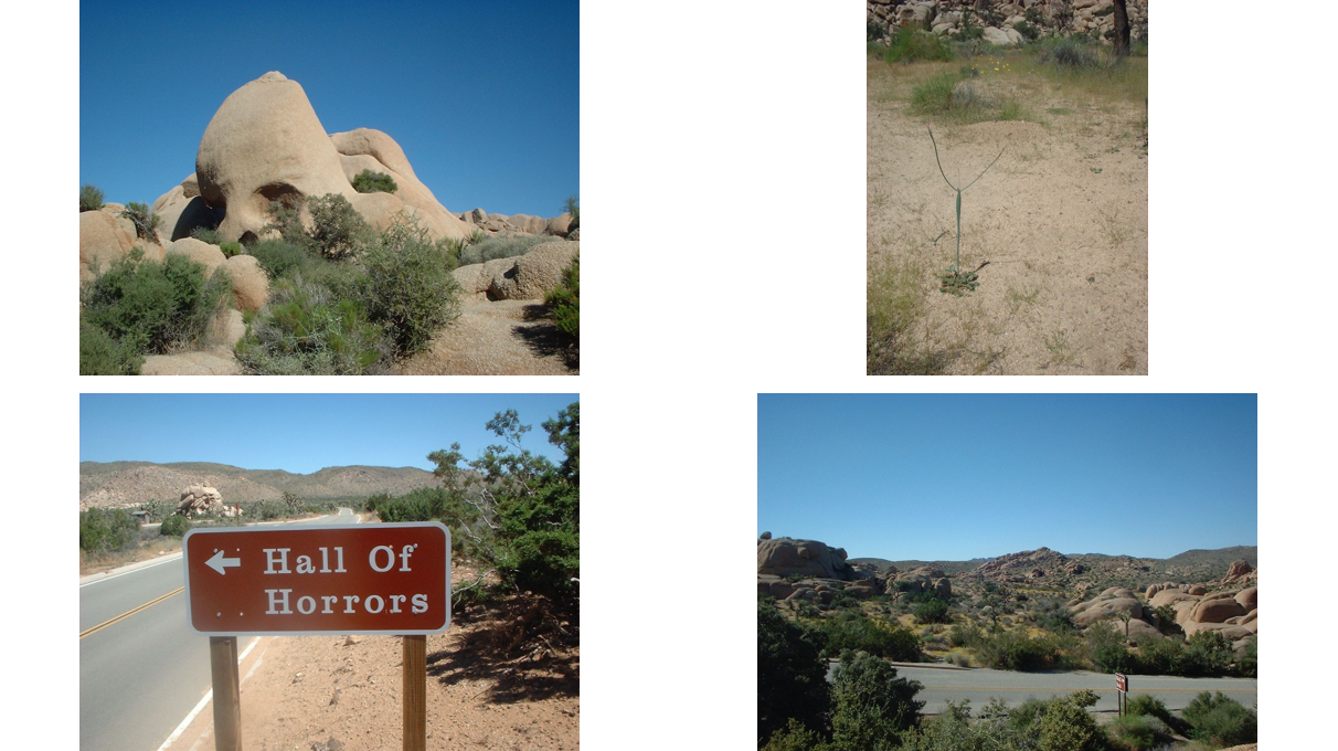
Hall of Horrors and Skull Rock, Joshua Tree National Park, California
Joshua Tree National Park is situated within the eastern part of California’s Transverse Ranges at the transition between the Mojave and Sonoran deserts.
About the park:
- The Joshua tree, a unique desert plant with beautiful white spring blossoms, is endemic to the higher, moister, and cooler Mojave Desert.
- The crystalline basement in the park consists of Proterozoic plutonic and metamorphic rocks. These were intruded by a composite Mesozoic batholith of Triassic-Late Cretaceous plutons.
- The basement was exhumed during the Cenozoic and underwent differential weathering. The deepest weathering profiles formed on the quartz-rich, biotite-bearing granitoid rocks, creating the odd-shaped boulders you see today.
- At Skull Rock, raindrops accumulated in tiny depressions and began to erode the granite. As more rock eroded, more water accumulated until, as time passed, two hollowed-out eye sockets formed and the rock began to resemble a skull.
- Geologist Laurie Stenberg (AECOM) and her husband Asim Ali visited Joshua Tree a few years ago. Stenberg says, “I love all the rocks at Joshua Tree, from the spooky, the amusing (thumb rock), to the sublime. And the plant life can look pretty weird too. The plant in the photo—I have no idea what it is—looks like a weird scrawny alien with its arms up. Ali adds “we were there in late August and the high temperature hit somewhere between 113–117 degrees.”
The bottom line: Hall of Horrors and Skull Rock are favorite stops for Joshua Tree National Park visitors. Both are easy trails that meander around boulders and desert washes and climb over boulder slabs. Hall of Horrors contains two short slot canyons—one only 6 inches wide. That would be a horror for me!
Witches Gulch at the Wisconsin Dells, Wisconsin
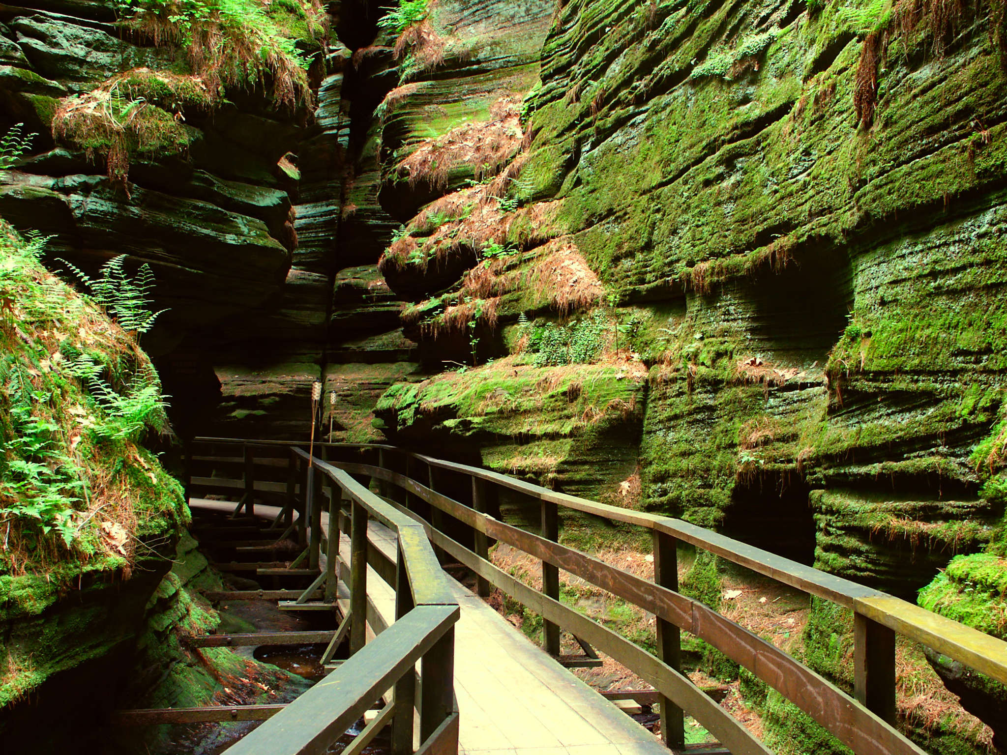
Located 50 miles north of Madison, the Wisconsin Dells is a series of picturesque sandstone cliffs towering over the Wisconsin River. The Dells have been a scenic vacation destination since the 1850s.
- The area is separated into the “Upper Dells” and the “Lower Dells” by the Kilbourn Dam.
- Witches Gulch is a narrow slot canyon within the Dells. The name originates from a Native American legend in which serpents and evil spirits are said to have formed the canyon.
- In 1875, the debris-choked passage of Witches Gulch was cleared, and boat tour landings began.
Area geology: Over 500 million years ago, the shallow Cambrian Sea covered the area. Sand and silt were deposited, later lithified to become the Cambrian Mount Simon Formation, a well-sorted quartz arenite, overlain by the Cambrian Wonewock Formation, a carbonate-cemented sandstone.
- Approximately 1 million years ago, several glacial lobes extended into parts of northern and eastern Wisconsin. The area of the Dells is on the extreme eastern margin of a “drift less” area, untouched by the glacial ice.
- Around 15,000 years ago, a continental glacier melted creating Glacial Lake Wisconsin, a massive lake held in place by an ice dam. The ice dam burst, and an enormous amount of water, rock, and debris carved deep gorges into the sandstones.
- Today, the Wisconsin River continues to sculpt the sandstone cliffs.
Trip tips:
- Experience the Wisconsin Dells by taking a boat tour. Operating season is April–October.
- Witches Gulch is on private property and is not accessible by hiking from the land: It is only reachable by boat tour through the Upper Dells.
- From the boat landing at Witches Gulch, hike the wooden boardwalk to experience the spooky moss- and fern-covered gorge, described as a “fairy-like” setting.
- The boat will also take you to Stand Rock, a towering sandstone pillar famous for the “dog leap,” where a dog jumps across the gap from one tall rock to another.
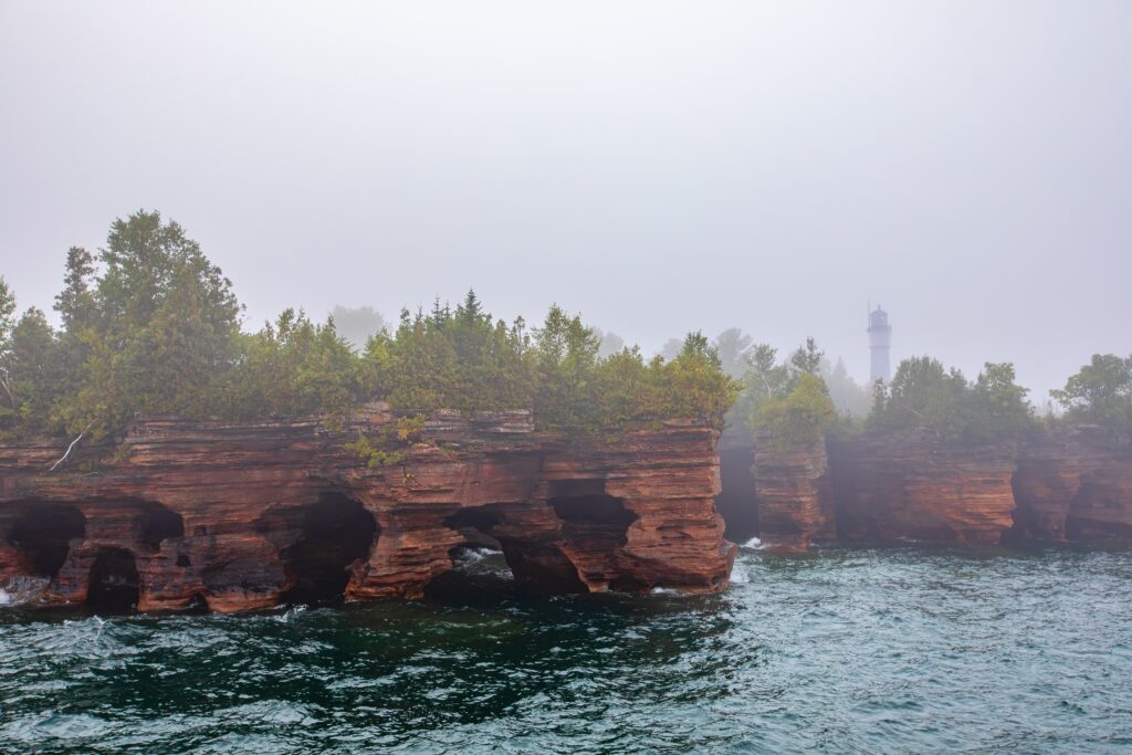
Devils Island, Apostle Islands National Lakeshore, Wisconsin
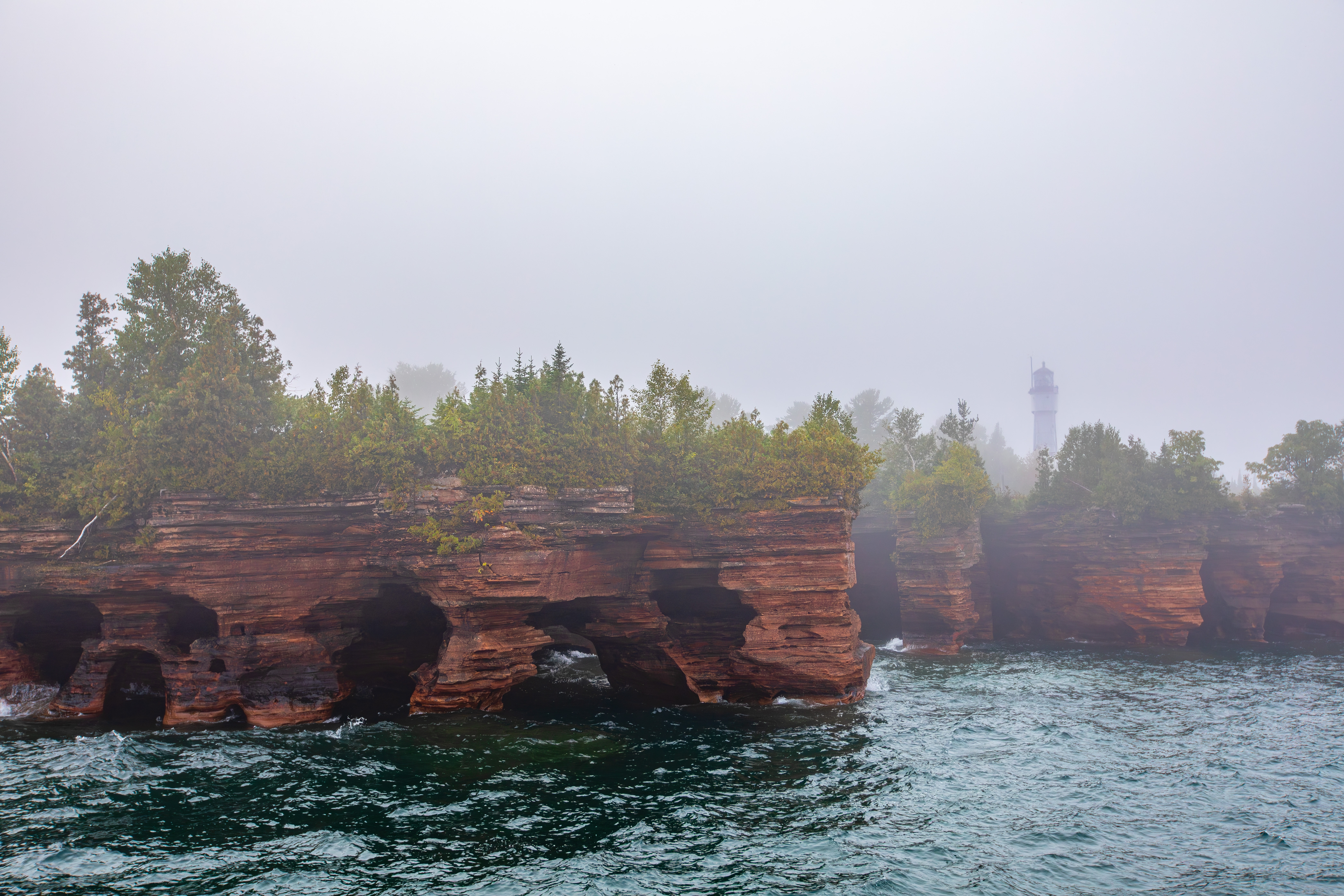
Devils Island is one of the 22 islands in the Apostle Islands National Lakeshore in western Lake Superior. It was once thought there were 12 islands in the Apostle archipelago, hence the name Apostle.
- Evil spirits or crashing waves? Devils Island’s name may be derived from a 1899 account of a Native story in which an evil spirit lived there… Modern Native scholars question this account.
- During times of heavy surf, waves crash deafeningly against Devils Island’s sea caves and around its arches, adding to its eerie atmosphere.
Area geology: Devils Island is composed of Mesoproterozoic (1 billion-year-old) Devils Island Sandstone, which is part of the Bayfield Group and the Keweenawan Supergroup.
- The Devils Island Sandstone is characterized by thin bedding and well-rounded quartz grains, by ripple marks, and by its pink to white color.
- The sandstone is interpreted as being a fluvial deposit in the center of the Lake Superior synclinorium. Streams deposited the sand in the enclosed basin, probably under desert conditions.
- No fossils are present in the formation.
- The Devils Island Sandstone is more porous and friable than the other sandstones of the Bayfield Group, enabling the erosion of more striking and larger sea caves.
Trip tips: Take a boat tour or water taxi to Devils Island. Trails lead from the three boat landings to the lighthouse.
- The island is also popular with kayakers.
- View the striking sea cliffs and caves, best seen near Squaw Bay, to the southwest.
- The island is wooded, and the dark foliage gives it a forbidding appearance.
- In the summer, Park Service volunteers staff the island. Then, visitors can climb the Devils Tower Light, built in 1894. It is the only Apostle lighthouse with its original Fresnel lens.
Fun fact: The northern tip of Devils Island is the northernmost point of Wisconsin.
Devil’s Punchbowl, Menomonie, Wisconsin
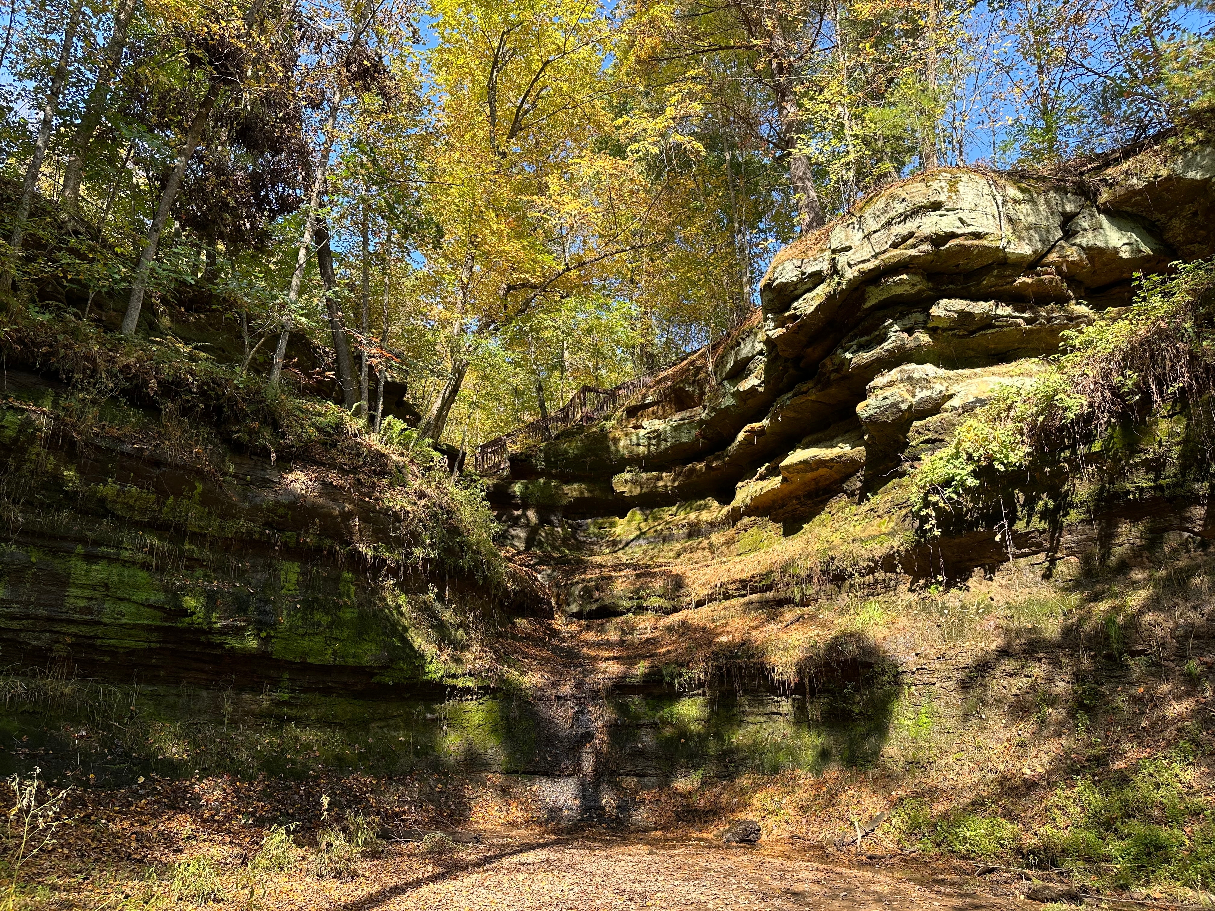
The Devil’s Punchbowl is a scenic bowl-shaped landform along the Red Cedar River Valley. Surrounded by layered rock faces dripping with groundwater, the area is covered with ferns, mosses, and sedges. A small waterfall spills over the top edge.
Spooky tales: To this day, stories of haunting ghosts and floating orbs surround the site. Gnomes climbing up the rock walls have been spotted.
- No one knows how the landform got its name, but the Devil’s Punchbowl was once owned by the University of Wisconsin-Stout. Their mascot is the Blue Devil.
Area geology: The surrounding rock consists of the Cambrian-aged Eau Claire Formation and the overlying Cambrian Wonewoc Formation.
- The porosity of the Wonewoc sandstone allows water to percolate through the rock. When the groundwater meets the more impermeable, shaly Eau Claire Formation, the water flows sideways and over the cliff face.
- The formations are part of the Sauk Sequence, major lithostratigraphic units that overlie Precambrian rocks of the North American craton. The sequence consists of nearly flat-lying marine sandstones. They are bounded on the bottom by the widespread Precambrian-Cambrian unconformity.
- As Pleistocene glaciers melted, massive amounts of meltwater and outwash eroded and carved the sandstone, hollowing out the circular ravine.
Trip tips: The Devil’s Punchbowl is owned by the West Wisconsin Land Trust and is free to visit.
- There are two short trails. The one to the top of the falls is an easy walk. The second trail is a challenging stairway down the slope and into the bowl. You must stay on the trails.
- Stand at the base of the natural amphitheater to experience the cool, flowing water surrounding you.
- In the winter, the water freezes, forming a spectacular scene of cascading icicles. The small creek in the middle also freezes, allowing you to get close to the frozen waterfall.
- The Punchbowl has a unique microclimate and supports more than 200 vascular plant species. It is also home to 19 species of land snails.