Field Seminar
Palermo, Italy
Thursday, 25 April 2024, 8:00 a.m.–9:00 a.m.
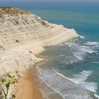
This one-day field trip will provide an introduction to a Miocene-Pliocene succession of southern Sicily, which includes outcrops of the Messinian Salinity Crisis (MSC), as well as the Messinian-Zanclean GSSP (Global Boundary Stratotype Sections and Point) and Zanclean stratotype. The MSC sedimentary record consists of an evaporitic-carbonate unit at the base (the Basal Limestone), overlain the Lower Gypsum unit, in turn overlain by the Upper Gypsum unit, and sealed by transgressive chalk deposits of the Trubi Fm. The Lower Gypsum unit (massive gypsum with cm-sized selenite crystals) will be visited along the beach of Siculiana Marina (about 15 km NW of Agrigento).
Next, we will visit near Capo Rossello (about 10 km NW of Agrigento) an outcrop of the Upper Gypsum unit consisting of clay-gypsum cycles and overlain by the Trubi Fm. The latter, at Scala dei Turchi beach, consists of chalk deposits arranged in a spectacular thick succession (~120 m thick) interpreted as astronomically-controlled depositional cycles. The uppermost interval of the MSC sedimentary record, including the Messinian-Zanclean GSSP, will be observed along the beach of Eraclea Minoa located about 20 km NW of Capo Rossello.
Pricing
Fee:
€50
Attendee Limit:
Min 15 - Max 50 People
Registration Deadline:
11 April 2024
Field Trip Rendezvous Point
Hotel nH Palermo
Field Trip Leaders
Antonio Caruso
University of Palermo
Attilio Sulli
University of Palermo
American Association of Petroleum Geologists (AAPG)
Added on 22 February, 2024
Field Seminar
Palermo, Italy
Sunday, 21 April 2024, 8:00 a.m.–5:00 p.m.
This one-day field trip will focus on Mesozoic (Jurassic to Cretaceous) carbonates outcropping in the fold and thrust belt of western Sicily and equivalent to the aquifer complex of the Sciacca Geothermal Field located in the southwestern part of the island.
Participants will have the opportunity to visit in the first stop a spectacular “drowned” carbonate-platform succession at Mt. Maranfusa located in an inactive quarry about 50 km SW of Palermo. The succession consists of Lower Jurassic peritidal cycles overlain by Middle Jurassic to Cretaceous pelagic limestone (e.g. ammonitic limestone, “chalk”) and marked by an unconformity with locally hardground. Syn-depositional Mesozoic tectonic is characterized by neptunian dykes and normal faults, whereas reverse faults, strike-slip faults, and joints are related to subsequent Cenozoic deformation.
In the second stop, at Mt. San Calogero, adjacent to the picturesque coastal town of Sciacca (about 100 km south of Palermo), we will visit the surface expression of an extensive karst system linked to uprising geothermal fluids. Furthermore, we will discuss main characteristics of the Sciacca Geothermal Field and its connection to deep mantle-derived fluids. Outcrop data will be integrated with both 2D seismic lines and exploration well logs showing the stratigraphy and structure of the deep aquifer. Given the presence of faults and joints in the outcrops, this field trip can provide the participants with valuable insights into naturally fractured reservoirs at the sub-seismic scale.
Pricing
Fee:
€50
Attendee Limit:
Min15 - Max 45 People
Registration Deadline:
11 April 2024
Field Trip Leaders
Gianni Mallarino
MOL Group
Attilio Sulli
University of Palermo
American Association of Petroleum Geologists (AAPG)
Added on 22 February, 2024
Field Seminar
Banff, Canada
Saturday, 11 May 2024, 8:00 a.m.–3:00 p.m.
Time:
8:00am - 5:00pm
Fee:
$300 AAPG members
$350 Nonmembers
$200 Academic/AAPG Emeritus Members
$50 discount for workshop registrants
Fee Includes:
Transportation
Insurance
Field guide
Entrance fee to Banff National Park
Registration available during workshop registration
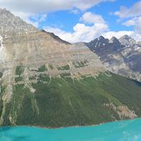
This field trip will focus on the structural geology of the foothills and Front Ranges of Banff.
Participants will be able to view excellent field examples of structures very similar to the producing oil and gas fields in the foothills to the west of Calgary and to learn about the complexities of sub-seismic-scale deformation.
The field trip starts with an introduction to the interaction between thrust front with foreland basins and the interaction of basement trends with thrust belt geometries and (conventional) hydrocarbon fields. During the 1-day trip participants will follow a dip transect from the undeformed foreland basin, the eastern edge of the foothills marked by the triangle zone, the Front Ranges boundary and end at the Main Ranges west of Banff.
Field Trip Itinerary
Depart from Calgary – 8:00 a.m.
Stop 1: Cochrane Retreat Road Overlook
Trip overview and introduction; safety and logistics comments; interaction of thrust front with foreland basin; interaction of basement trends with thrust belt geometry and (conventional) hydrocarbon field distribution; appreciation of scale for subsurface play fairway.
Stop 2: Scott Lake
Stop 3: The Stony Nakoda Tim’s
Classic stop, with historical importance for understanding the thrust belt and thrust geometry. Part 1 of displacement gradient on a large thrust. Most importantly, toilet stop after all the Tim’s coffee and driving. Review of Mt Yamnuska from a different perspective; preview of drive through McConnell damage zone and change in HW stratigraphy..
Stop 4: Lac des Arcs
Imbricate thrust sheets in the Front Ranges and Banff Formation.
Stop 5: Canmore T-junction
Observe complexities of sub-seismic-scale deformation in mechanically layered rocks in the footwall of a large thrust
Stop 6: Canmore strike view of the Rundle thrust
Exposed strike view analogous to a cut-away of a giant conventional Foothills hydrocarbon field such as Turner Valley. Cross faults within the thrust sheet offset potential reservoir units at sub-seismic scale. Cross faults are arguably part of a regional trend associated with deeper, basement-rooted NE-SW structures.
Stop 7: Mt Norquay Overlook
Stop 8: Bow Falls
Fracture systems in the Vega Siltstone Mbr of the Triassic Sulphur Mtn Fm. This outcrop of Vega Member siltstone of the Sulphur Mtn Fm is considered equivalent to upper Montney Fm. We will focus on the outcrop adjacent to the steps up to the Falls overlook.
American Association of Petroleum Geologists (AAPG)
Added on 16 February, 2024
Workshop
Palermo, Italy
Monday, 22 April – Wednesday, 24 April 2024, 8:00 a.m.–5:00 p.m.
This Symposium marks a collaborative event that brings together AAPG Europe and AAPG Middle East, with a central focus on carbonates and mixed carbonate systems worldwide, while highlighting their significance within these two regions. The primary objectives are an overview of controls that govern the evolution of these systems in time and space and the characterization and prediction of their properties across scales.
American Association of Petroleum Geologists (AAPG)
Added on 05 October, 2023
Workshop
Abu Dhabi, UAE
Monday, 27 May – Wednesday, 29 May 2024, 8:00 a.m.–5:00 p.m.
In order to support the energy transition, optimizing exploration and production from complex stratigraphic-diagenetic conventional and unconventional plays remains highly important. At the same time, Carbon Capture and Storage (CCS) poses new technological challenges that will impact both the industry and academia for decades to come.
This 2nd edition will present reviews and discuss technology developments in geological process-based forward modeling achieved during the last 2 years. New perspectives for future technology developments and implementation in industry workflows will be discussed and with the additional focus on CO₂ storage and other sustainability-related applications, the scope of the workshop will be considerably extended.
American Association of Petroleum Geologists (AAPG)
Added on 05 September, 2023