Understanding the role and influence of salt in the subsurface has been the key to many hydrocarbon discoveries and appraisals and more recently carbon & hydrogen capture and storage, and geothermal interests. Now, AAPG has a new Technical Interest Group, co-founded and co-chaired by Clara Abu (Ph.D Candidate Imperial College), Rachelle Kernen Ph.D., Leonardo Muniz Pichel Ph.D., Clara Rodriguez Ph.D., and Tim Shin, MSc. Welcome to an interview with Clara Abu, one of the co-founders. To join the Salt Basin TIG, please visit their website.
What is your name and your background?
I am Clara Abu, a Petroleum geoscientist, seismic interpreter, salt-tectonics enthusiast in the Digital Subsurface Solutions team at Schlumberger UK. I am co-founder and co-chair of AAPG Salt Basins Technical Interest Group and an AAPG EC coordinator tasked with increasing diversity, equality and inclusions in the geosciences.
I received my BSc Honors in Geology from the University of Ibadan in Nigeria. I started an internship with Texaco Overseas, Lagos soon after graduation. I subsequently worked for ExxonMobil in Nigeria in 2002 under a new hire scheme which provided exposure to formation evaluation/operations geology, production and exploration geoscience in several locations including Houston, Texas, USA. I thereafter pursued an MSc in Petroleum Geoscience at Imperial College London to diversify my understanding which involved teamwork in multidisciplinary reservoir management groups.
I started a role in Schlumberger UK as an exploration geoscientist and seismic interpreter in 2009 and this gave me the opportunity to work in several basins offshore West Africa, East Africa and the North Sea. After five years in Multiclient team, I started to work with the Geosolutions team for an additional 5 years. Being a salt enthusiast, I was keen on getting in-depth understanding of the role and influence of salt on petroleum systems and further investigate exploration related implications of mass transport complexes in various basins which took me back to Imperial College for a part time doctoral research with the Basin Research group.
How did you become interested in geology?
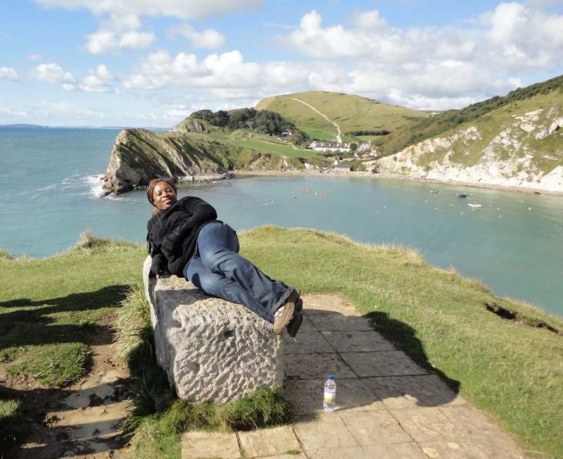
Clara at the Lulworth Cove, Dorset, England. The image is taken from the main path to the cove. The chalk is on the right, the Portland and Purbeck group in the middle, and the Wealden beds to the left.
Surprisingly my first choice of study was medicine at the University, which is typical as students from my part of the world are encouraged to study Medicine, Engineering, Law and Accounting. However I ended up enrolling for geology instead as I heard several stories of how profitable the oil industry was. My first year at University went well, I was still doing the subjects I loved; maths, chemistry, physics but by second year, an introduction to petroleum geology got me hooked and I sought opportunities that broadened my understanding of processes that created rocks and landforms and the history of how the earth was formed. Since then I have been transfixed in the world of geoscience.
How did you become interested in salt basins?
A considerable aspect of my job at Schlumberger involves 3D seismic interpretation of salt bodies offshore Angola in the Kwanza Basin and offshore Gabon. These are integrated into building velocity models used in depth migrations. I became more intrigued in understanding how this complex salt bodies formed aside from clicking away non-stop at my workstation.
What are some of the major challenges with salt basins?
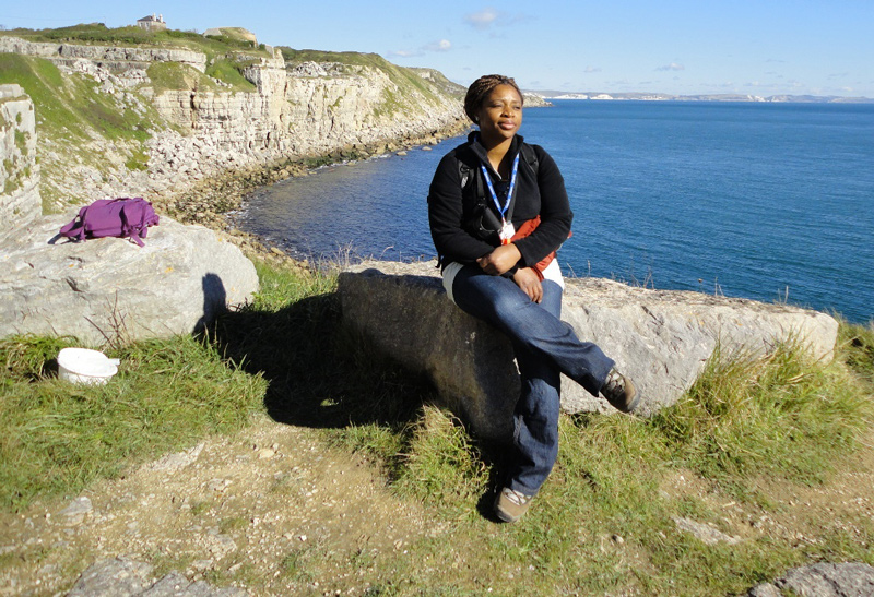
Clara at a Portland outcrop that shows good succession including the Portland Cherty series, the Portland freestone (quarry stone) and base of Purbeck Formation, Wessex Basin, Dorset, England
Salt basins are one of the most prolific hydrocarbon provinces in the world, manifesting in giant pre-salt oil and gas fields. There are several structures formed as a result of geologically complex geometries of salt including turtle back, salt flank wedge structures, roll over anticlines, sub salt plays, and presalt structures that are capable of trapping hydrocarbons.
A key challenge is imaging - complex shapes of salt bodies, steep dips, strong acoustic impedance and velocity contrast at the salt/sediment interface, complex presalt with fast carbonates, slow sediments, volcanic layers and complex fault systems, all result in complex ray paths, seismic velocity anisotropy, complex P and S wave conversions and reflected refractions. This generates false and confusing salt body images which is very complicated and challenging especially during migration and velocity model building stages.
Another challenge is the variation in salt composition due to other evaporitic components apart from halite in various proportions. Previous velocity models represented salt as homogenous but there’s a lot of evidence from well logs, and cuttings, seismic layering that suggests some heterogeneity, hence more realistic velocity models are required for better geologic control.
The use of traditional seismic interpretation involving single-z approach is time-consuming and labour intensive. There are potential velocity errors along salt/sediment interface, compromising on smaller vertical scale variability and associated modelling challenges. The use of multi-Z meshing is a stronger approach which saves time.
These challenges can be mitigated with technological advancements in acquisition (wide, full, multi azimuth), broadband processing technologies integrating ultimate depth migration techniques such as Reverse Time Migration (RTM) salt modelling. Detailed geological interpretation is also crucial for regional evaluation and identifying future salt-related prospectivity.
Please describe a new technology or technique that is making a difference in salt basin exploration and development.
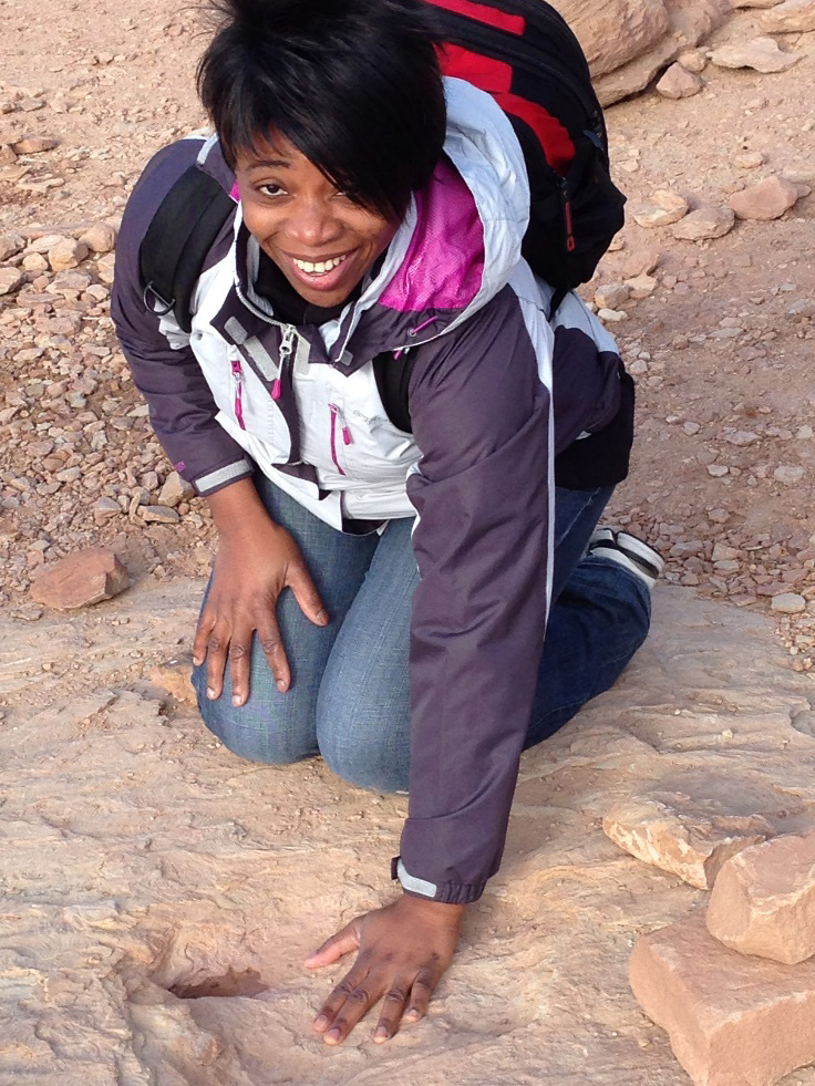
Clara pointing at preserved Dinosaur tracks of Copper Ridge. The trackways cross what was 150 million years ago, a ripplemarked sandbar along a river. The tracks are preserved at the top of the Salt Wash Member of the Morrison Formation, Utah, USA
In recent years, technological advancements in geophysics are providing better data – Full azimuth, low frequency and ultra-long offset sparse nodes combined with full record FWI imaging and ultra large scale wide-azimuth (WAZ) provide efficient coverage over large areas and better illumination of targets in complex salt regions. Broadband processing rich in high and low frequency content provides deeper penetration and good subsalt illumination which allows a better imaging of steep faults and salt flanks.
Another aspect is high resolution anisotropic earth models involving superior wave field extrapolation techniques such as Full Waveform Inversion (FWI) that improves reliability in both structural and amplitude interpretations and provide more geological insights in the basin. Pre-stack depth imaging techniques like RTM (Reverse Time Migration) correctly portrays geometries of salt and Least-squares migration. These technically robust solutions will provide step-change improvements in imaging and advance our understanding of the evolution and impact of the salt on the overall petroleum system (reservoir, trap, seal, maturity and timing), unlock vast potential and boost exploration in salt basins.
From an interpretation standpoint: (a) integrating machine learning aided salt body interpretations as part of seismic imaging workflows will reduce time consuming subjective salt interpretation tasks, (b) combining high resolution gravity and magnetic data to reduce uncertainty in deeper salt structure and basement interpretation and (c) incorporating seismic interpretation with outcrop and efforts from numerical and physical modelling will improve our understanding of salt basins.
Where do you think there will be breakthroughs -- in new basins, improved levels of recoverable reserves, improved modelling and characterization, or other area? Why?
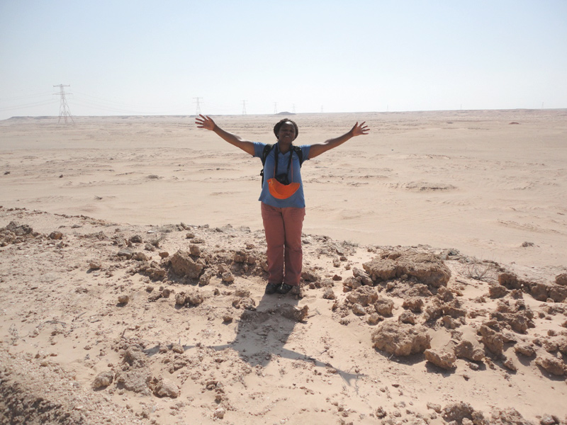
Lucky to stand at the floor of a continental sabkha (Abu Dhabi) during a particularly hot day. These continental sabkhas are difficult to cross after rains and flash floods.
Pre-salt carbonate reservoirs in the Santos and Campos Basin, offshore deep water Brazil, Ultra deep waters and pre-salt formations in the Gulf of Mexico are exploration hotspots and will continue to be major hotspots for global exploration. Advancements in technology including broadband reprocessing and template matching FWI workflows which enable imaging improvements in highly complex salt environments will support future salt-related prospectivity. In addition to this, applying new and innovative technologies in artificial Intelligence/machine learning will improve production efficiency, accuracy and reduce turnaround time whilst allowing geoscientists more time for creative thinking and development.
Please recommend a book or two that you think the readers might enjoy.
My favourite is ‘Salt Tectonics: Principles and Practice" Jackson and Hudec (2017)’ which is well- written and delves into various aspects of salt. I particularly like the illustrations in ‘The Salt Mine: A Digital Atlas of Salt Tectonics. Hudec and Jackson (2011)’. The ‘Permo-Triassic Salt Provinces of Europe, North Africa and the Atlantic Margins: Tectonics and Hydrocarbon Potential. Juan I. Soto, Joan Flinch, and Gabor Tari (2017)’ is another recommendation.