Nano-satellites combined with advanced analytics are transforming the surface imaging world. Welcome to an interview with Sean Donegan, CEO & President and Allan Adams, Director of Science and Professional Services, both of Satelytics, who talks about how surface image analytics have transformed what we can learn from surface data.
What is your name and your relationship to surface image analysis?
Sean Donegan and Allan Adams work with nano-satellites and analytics in a new company, Satelytics. Satelytics is a portmanteau of ‘satellite’ and ‘analytics’ that details our software process of taking satellite and aerial data and rendering to the customer actionable analytics. Though we take data from planes, drones, and other sources, we work with satellite imagery most often, and that’s where we see a great deal of our company’s current and future work.
We don’t own any satellites, we want to be the interface between satellite and aerial imagery providers and the people seeking to solve business problems.
What is Satelytics? How did it get started?
Satelytics is a big data analytics software-as-a-service. We take in large volumes of multi and hyperspectral imagery—often terabytes—from satellite or aerial sources, run complex processing algorithms on our cloud-based platform, and render the data into dashboards, charts, tables, maps, and insights that businesses can use to make operational decisions. Images sources can include satellite, nano-satellite, drone/UAV, plane, or fixed/persistent platforms.
Satelytics began as Blue Water Satellite out of Bowling Green, Ohio. We became Satelytics in 2016. Blue Water Satellite was started by Dr. Robert K. Vincent, a University of Michigan Doctor of Geology who pioneered analyzing imagery over water bodies for conditions that would lead to harmful algal blooms (phosphorus, phycocyanin, and chlorophyll a), identifying pollution point sources, and reporting on treatment efforts.
We discovered there is a massive, unfilled demand for analyzing such large datasets in many industries including oil & gas, pipeline, power, or any industry with large, geographically dispersed infrastructure beyond just water & wastewater. The technology is particularly useful in risk mitigation and disaster remediation, for example: Hurricane Harvey and Irma, where Satelytics can provide before and after change comparisons to identify where power and oil & gas operators need to focus their repair efforts.
Satelytics uses the science of remote sensing that allows us to uncover data on constituents, biological contaminants, and other qualities in satellite imagery. I’ve attached some brief slides on how the science works. See: how-satelytics-works.pdf.
What are nano-satellites?
A nano-satellite is a type of “small satellite,” that weights between 1 – 10kg and measure less than a meter squared. Nano-satellites, due to their small form factor and light weight, are significantly cheaper to build and launch en masse. Traditional satellites, by comparison, are massive and massively expensive. They’re often the size of a bus, they’re very costly to launch, and they can take a decade or more to develop. Nano-satellites can be launched in meshed networks called “constellations” allowing them to revisit the same spot on Earth multiple times per day.
For example: Satellogic out of San Francisco is launching a constellation of 300 nano-satellites and expects to reduce the average revisit time to around 5 minutes anywhere on the planet. Clouds are always a problem for any aerial platform, but increasing revisit frequency increases the chances that we have a successful image capture. Nano-satellites also mean a drop in the highest costs of hyperspectral data and increases the availability of the imagery for all of our customers.
Nano-satellites are being driven by technology giants.
Paul Allen, co-founder of Microsoft, backed Black Sky, a remote sensing satellite constellation operator. Google signed a major equity stake in Planet Labs in early 2017, one of the largest constellation providers. Michael Arrington, founder of TechCrunch, invested in Satellogic through his fund, “CrunchFund,” as part of a $27 million Series B round. Elon Musk plans to launch over 4,000 nano-satellites into low-Earth-orbit to provide cost-effective, global internet.
What kind of sensors do nano-satellites have?
Because they’re manufactured and launched much more quickly, nano-satellites can often have the same or better sensors and payloads, covering more bands in higher resolutions, than payloads on traditional satellites. Traditional satellites take so long to build that their underlying technology is often dated by the time they’re launched, but nano-satellites are able to respond to technology trends more quickly and put them into use as soon as they become commercially available.
How do you process the images from aerial platforms?
Satelytics has established a pipeline of imagery vendors including satellites, drones, planes, and other sources. The data is loaded into our cloud-based, automatically scaling, and AWS hosted software platform. We then run our complex, machine learning algorithms on the imagery to extract the critical data showing the constituents or phenomenon our customers are looking for. Our algorithms also adjust for a number of variables, like atmospheric conditions, to ensure a consistent, reliable output.
Our software then distributes this to web and mobile dashboards, text and email alerts, and third-party software via a feature rich API.
What are some of the applications? Can you provide two or three examples?
Water Quality
Satelytics can detect biological and chemical contaminants in bodies of water, large or small. Our process can detect constituents, such as heavy metals, phosphorus, phycocyanin, and chlorophyll-a, down to parts per billion.
Toxic Algae Blooms
Satelytics can see the algae itself by detecting phycocyanin and chlorophyll-a, the pigmentation cells in blue-green algae, the primary type of algae comprising toxic algae blooms. Satelytics detects phosphorus, a common ingredient in agricultural fertilizer, and water temperature, which can spur algae growth. Satelytics can be used in predictive modeling for algae blooms, remediation efforts, mapping them, and identifying pollution point sources. Satelytics has been used to identify algae blooms near power stations that intake contaminated water for cooling. This can interfere with the turbines and interrupt plant operations.
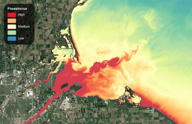
This image shows phosphorus loading from the Maumee River into the Western Basin of Lake Erie. Phosphorus is the primary ingredient in agricultural fertilizer and the food source of blue-green algae. In 2014, blue-green algae was responsible for shutting down the water supply to over 400,000 Toledo region residents.
In 2014, Toledo’s water supply was contaminated with Microcystin, a toxin that cannot be boiled away and causes extreme sickness and even death, that is the byproduct of blue-green algae. Here’s an article with imagery showcasing our work over Lake Erie mapping phosphorus contamination that fuels algae growth.
Copper Particulate on Roadways
Satelytics has been used to identify copper particulate from brake dust on roadways and how it washes away into the neighboring waterways. Here’s an article with imagery showing our work detecting heavy metals on the streets of Los Angeles.
Right-of-Way Monitoring
Pipeline and energy transmission companies have a set of threats and risks they monitor for along their pipeline and powerline right-of-ways including new construction, downed power poles, human activity, erosion, land movements, and more. These right-of-ways can cover thousands of miles of terrain, and they’re currently monitored via manual inspection either on foot or by plane. This process is time consuming, error prone, and potentially hazardous. Missing or failing to document threats could mean they eventually progress and damage the infrastructure, interrupt operations, or in the case of pipelines, cause a leak that leads to environmental contamination and poses a public health risk, not to speak of regulatory consequences.
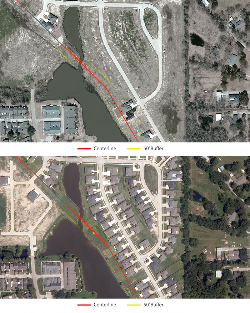
This image shows housing being constructed over a pipeline right-of-way. Pipeline companies are often not alerted to human activity near their pipeline, and they’re required to take extra safety measures and precautions in these high consequence areas (HCAs).
Satelytics allows machines to do the repetitive task of analyzing right-of-ways, automatically recognizing threats, and bringing them to the attention of operators allowing them to better focus their resources and capital spending and get ahead of potential problems.
Monitoring 6,000 Miles of Pipeline
Satelytics was employed by a large pipeline operator. Traditional method of assessing their right of way took 18 months and 12 employees.
Satelytics was employed to automatically assess for the following:
- Encroachments
- Population Growth
- Change Detection
- Land Use Classifications
- Water Crossing Changes/Erosion
- Vegetation Encroachments
- Small Lakes
Satelytics found over 50,000 objects, bodies of water, structures, or other man-made objects unknown to the company prior to using Satelytics. The pipeline assessment with Satelytics was completed within three months—using three employees and with a full return on investment within 8 months.
Leak Detection
Satelytics can monitor oil & natural gas fields, offshore platforms, and pipelines for leaks on both water and land. SCADA systems are very good at detecting pressure drops from large leaks, but the vast majority of oil spilled by volume are small leaks that often go undetected for weeks or months before they’re spotted by aerial or field crews. Satelytics can detect these leaks far sooner.
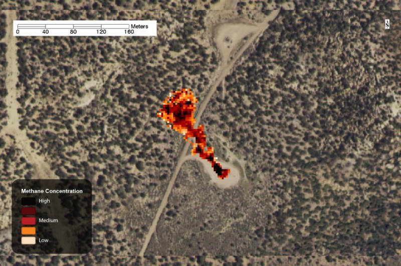
This image shows the Satelytics methane detection algorithm in action. Using aerial imagery taken by plane, Satelytics was able to detect several leaks at natural gas well pads located in the San Juan Basin methane hotspot.
In August of 2015, we were asked to look at a known leak site for a supermajor oil & gas operator. During the analysis, we discovered two additional leaks that the company was previously unaware of. Here’s an article with imagery and more explanation of a case detecting oil pipeline leaks.
In May of 2016, a supermajor operator discovered a leak of around 88,200 gallons of crude near their Gulf Coast platforms. The leak was discovered by air while transporting employees to the platform. By examining historical data, we determined Satelytics would have discovered the leak upward of four months earlier when the leak was 50% smaller. Here’s an article with imagery and more explanation of a case detecting offshore oil spills.
In February of 2017, we released the world’s first methane detection service platform, and we’re one of the only commercial products that can see methane in high enough resolution to determine individual wells or pipelines that may be responsible.
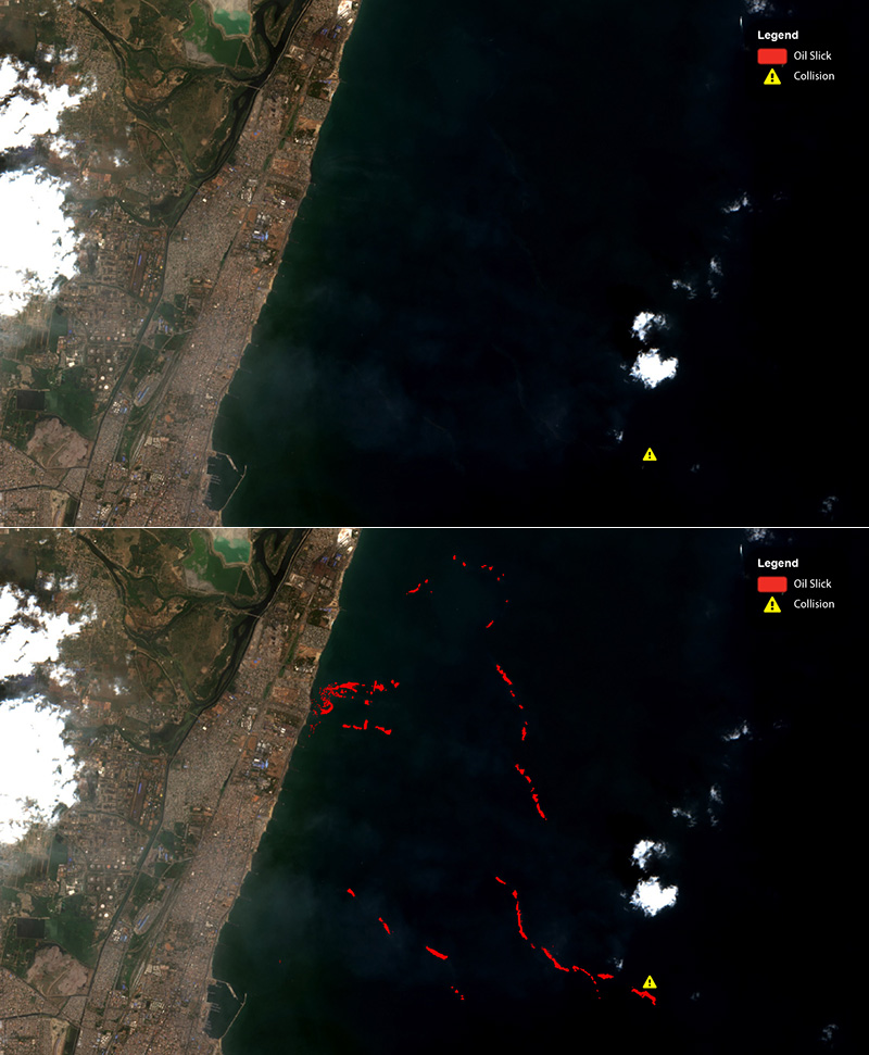
This image shows a tanker collision off of the coast of Chennai, India and the resulting oil spill. The first image is before analysis, the second image is after analysis showing the wide extent of the spill.
Health, Safety & Environment (HSE, EHS)
Satelytics can be used to monitor resources near oil & gas extraction operations for environmental contamination. We can detect a broad range of heavy metal constituents such as arsenic, copper, barium, manganese, and others that are discharged into the environment as a byproduct of regular operations.
This contamination poses health risks to employees, negatively impacts the environment, and exposes the company to potential regulatory consequences.
Satelytics can monitor remediation activities after contamination has occurred allowing operators to track their progress and provide a regulatory audit trail. In the North Slope region of Alaska, a supermajor oil & gas operator used Satelytics to monitor over 65,000 lakes and small bodies of water (billions of individual pixels) for potential heavy metal contaminants near extraction operations.
How can Satelytics be used for recovering from natural disasters? Can it be used for small community recovery?
As part of the emergency response, Satelytics can analyze areas before and after weather events. Satelytics can be used to ascertain structure and vegetation loss after a disaster, or identify areas where topsoil, riverbanks, and coastlines have eroded and may pose a risk to infrastructure. Satelytics can also be used to map downed power poles and other damaged infrastructure to show disaster recovery crews where to direct their resources.
What are Satelytics’ plans for the future?
As nano-satellites continue to proliferate, we’ll be able to process terabytes of imagery and monitor locations in near-real-time. This is a critical inflection point for Satelytics because it places us on the operational frontlines. At this rate, we could watch an erosion event develop, or a leak take form, in as close to real time as possible allowing operators to react to threats immediately.
We’re really just scratching the surface, and we’re solving new business problems every day.
In February, for example, we released methane detection, and we became one of the first commercial services to offer this capability.
Because we can conduct multiple analyses on the same imagery, multiple departments can share the cost of image acquisition. Integrity departments, risk management, leak detection, vegetation management and others can process the same imagery for different phenomenon, and this list grows as we grow the number of business problems we solve for.
Sean Donegan, CEO & President at Satelytics, has a long history of entrepreneurship in the software industry culminating in the sale of an internationally recognized document management software company and an oil & gas predictive analytics software company.
Allan Adams, Director of Science and Professional Services at Satelytics, has an undergraduate degree in Geology from Grand Valley State University in Michigan and a graduate degree in Geology from Bowling Green State University where he studied under renown remote sensing pioneer, Dr. Robert Vincent.