
Sinamar-1 was the first exploration well drilled in the Ombilin Basin of West Sumatra. It was also the first well drilled in an intermontane basin within the active volcanic arc of western Indonesia, known as the “Ring of Fire.”
The drilling was a milestone event whose rationale is important for explorers to understand. To that end, a review of Indonesia’s oil history is in order.
Surface oil and gas seeps in Indonesia have been known for generations. Since time immemorial, small-scale exploitation of these seeps was done by the local population. The main use of surface oil was in medication and as a balm, and also for caulking of their “prahus” (canoes) and for lubrication.
Many settlements and small rivers throughout the Indonesian archipelago are identified by the Malay word for oil, “minyak tanah,” meaning “oil from earth,” and “sungei minyak,” meaning “river of oil.” Another example is a village called Kampong Minyak, meaning “village of oil,” located in the Kampung Minyak oil field discovered in 1896, east of the town of Mura Enim in the Palembang sub-basin of South Sumatra.
The first drilling for oil in Indonesia, at that time called the “Netherlands East Indies,” occurred in North Sumatra. In July 1884, the Dutch planter, A.J. Zijlker drilled the shallow Telaga Tiga -1 well on a surface anticline where the local people had converted an oil seep into an oil pit. That September, at a depth of 97 meters, the well encountered a strong flow of water, oil and gas. A flow test showed production of 200 liters of oil per day. The well was followed by a delineation well, Telaga Tunggal-1, drilled 1.5 kilometers eastward to a depth of 122 meters, which found oil described as “excellent quality.”
Zijlker’s efforts led to the founding of the Koninklijke/Royal Dutch oil company in 1890. More oil wells were drilled, and a 12-kilometer pipeline was built in the heavy jungle from Telaga Tunggal to the coastal village of Pangkalan Brandan. In February 1892, Indonesia’s first oil production commenced. The company formed to extract, refine and market this Sumatran crude merged in 1907 with Britain’s Shell Transport and Trading Company and became the Royal Dutch/Shell group of companies, eventually known worldwide simply as “Shell.” During the first half of the 20th century, Royal Dutch/ Shell was the dominant oil producer operating in the Dutch colony of Netherlands East Indies.
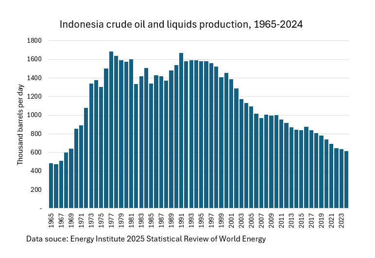
Thereafter oil and gas exploration occurred throughout Indonesia, both onshore and offshore, with oil production peaking at 1.6 million barrels of oil per day in 1981 and steadily declining to the current 600,000 bopd. Indonesia currently consumes approximately 1.6 million bopd, so the country needs to import 1 million bopd at a cost of $22 billion per year (based on $60/barrel). The Indonesian government has set an ambitious target of achieving daily oil production of 1 million bopd by 2030 to strengthen the nation’s energy security.
Among Indonesia’s oil industry’s milestone events since that first drilling in 1884, was the discovery in 1944 of the super-giant Minas oil field in Central Sumatra. The discovery well was drilled by the Japanese occupation forces on a prospect delineated in 1941 by the American oil company Caltex. Minas became the largest oil field in Southeast Asia.
I was personally involved in another milestone: the first exploration for oil in Indonesia’s Ring of Fire, which culminated in drilling Sinamar-1 in 1983.
The Opportunity to Work in Indonesia
Holland-born but Canada-raised, I joined Texaco in Calgary in 1973. In 1979, they offered me a job as senior geologist in Sumatra, working for PT Caltex Pacific Indonesia, the oil company owned 50/50 by Texaco and Chevron. I jumped at the opportunity since I had heard all about Indonesia from various Dutch relatives.
Caltex had major oil production in the Paleogene Central Sumatra back-arc rift basin. At that time, Caltex produced about 500,000 bopd, roughly half of Indonesia’s daily oil production.
The job location was in the Caltex camp called Rumbai, located just north of Pekanbaru, the capital city of the province of Riau in Central Sumatra. Surrounded by dense jungle, Rumbai was only 60 kilometers north of the equator. The elevation was just 12 meters above sea level, and the climate was hot and humid, typical of the tropics. The oil exploration and production programs were carried out by Indonesians and expatriates living and working in Rumbai. The oil producing area was primarily low swamp and extensive thick jungle.
My wife and I planned to stay for just two years since Rumbai was isolated and viewed as a hardship post. But instead of staying two years, we stayed seven due to my fascination with the geology of Indonesia, our affection for the friendly and welcoming Indonesian people and the opportunity to travel all over Indonesia and Southeast Asia.
Exploring in the Ombilin Basin
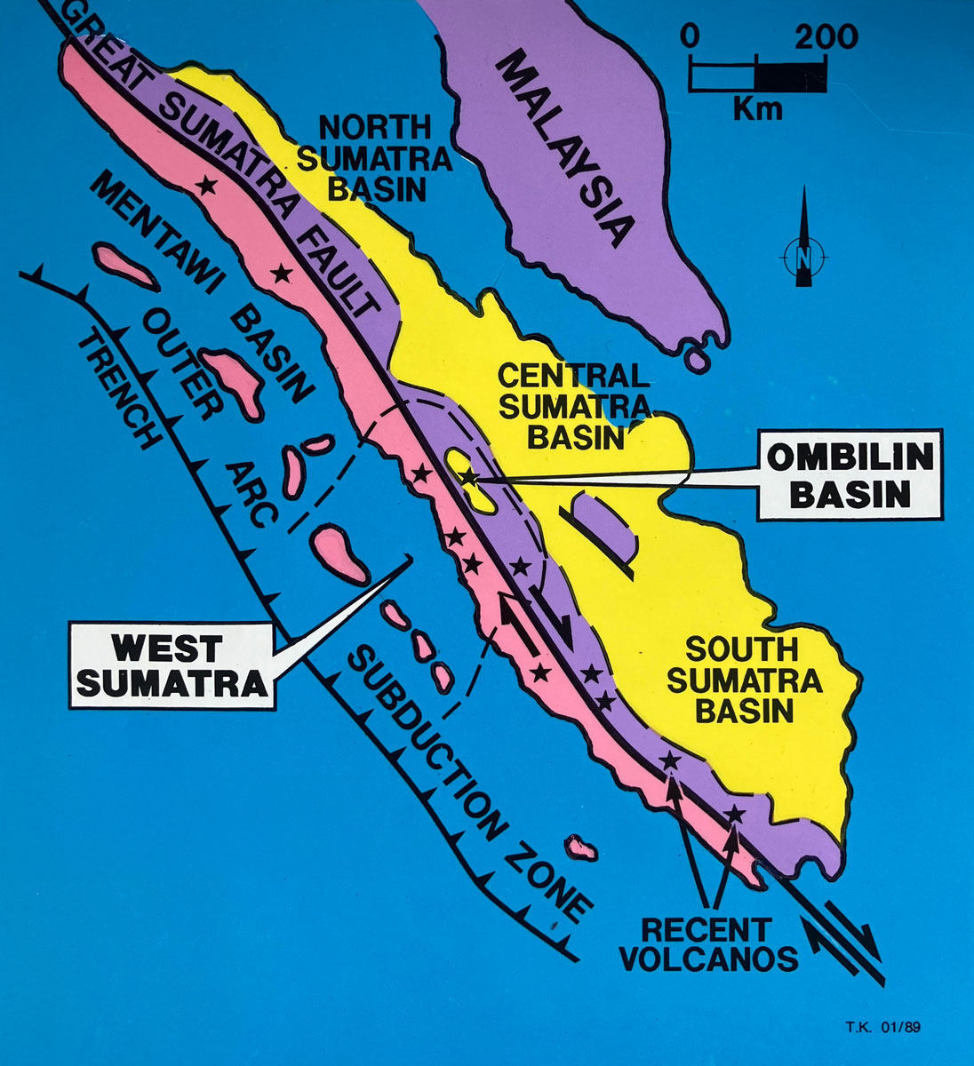
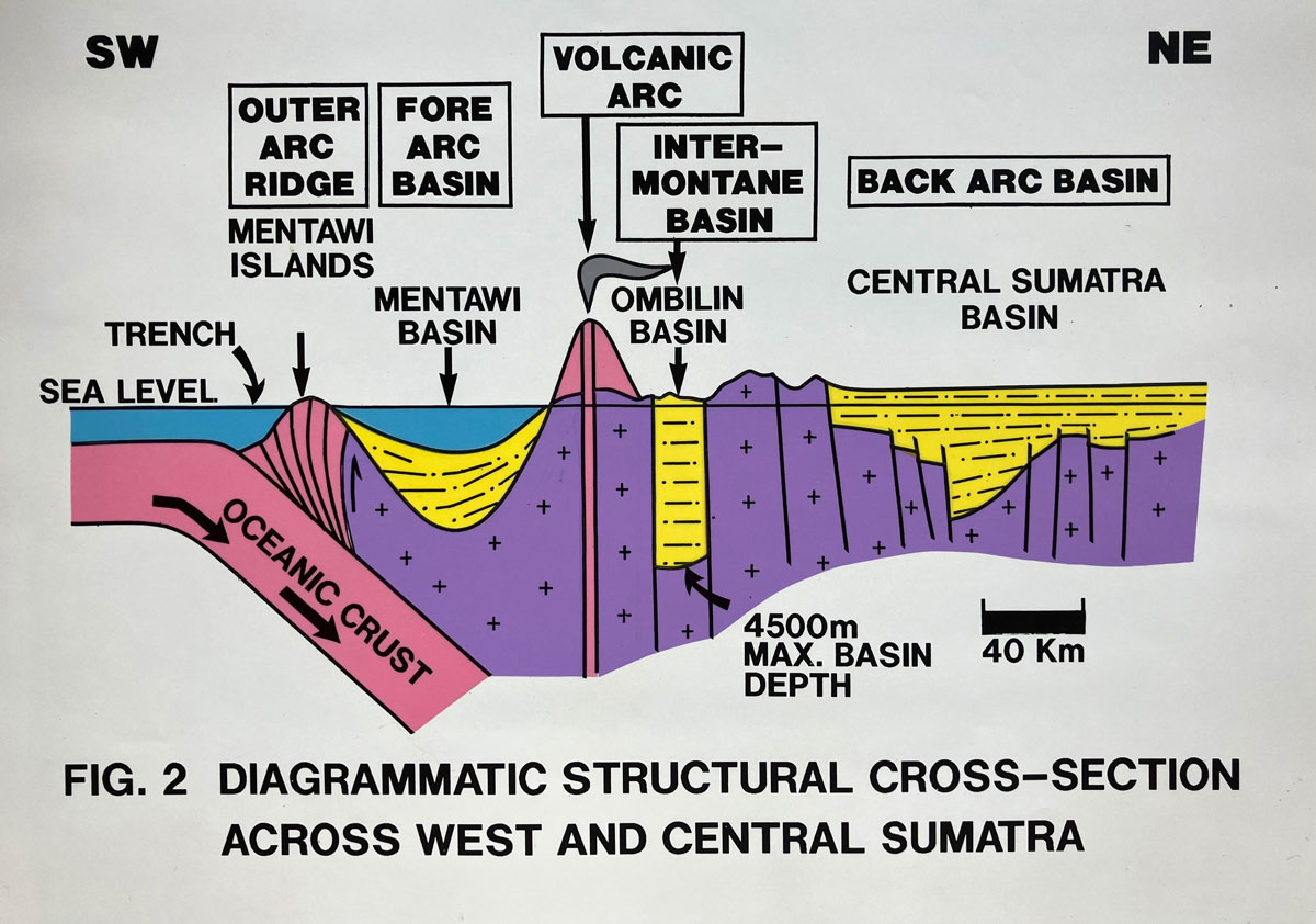
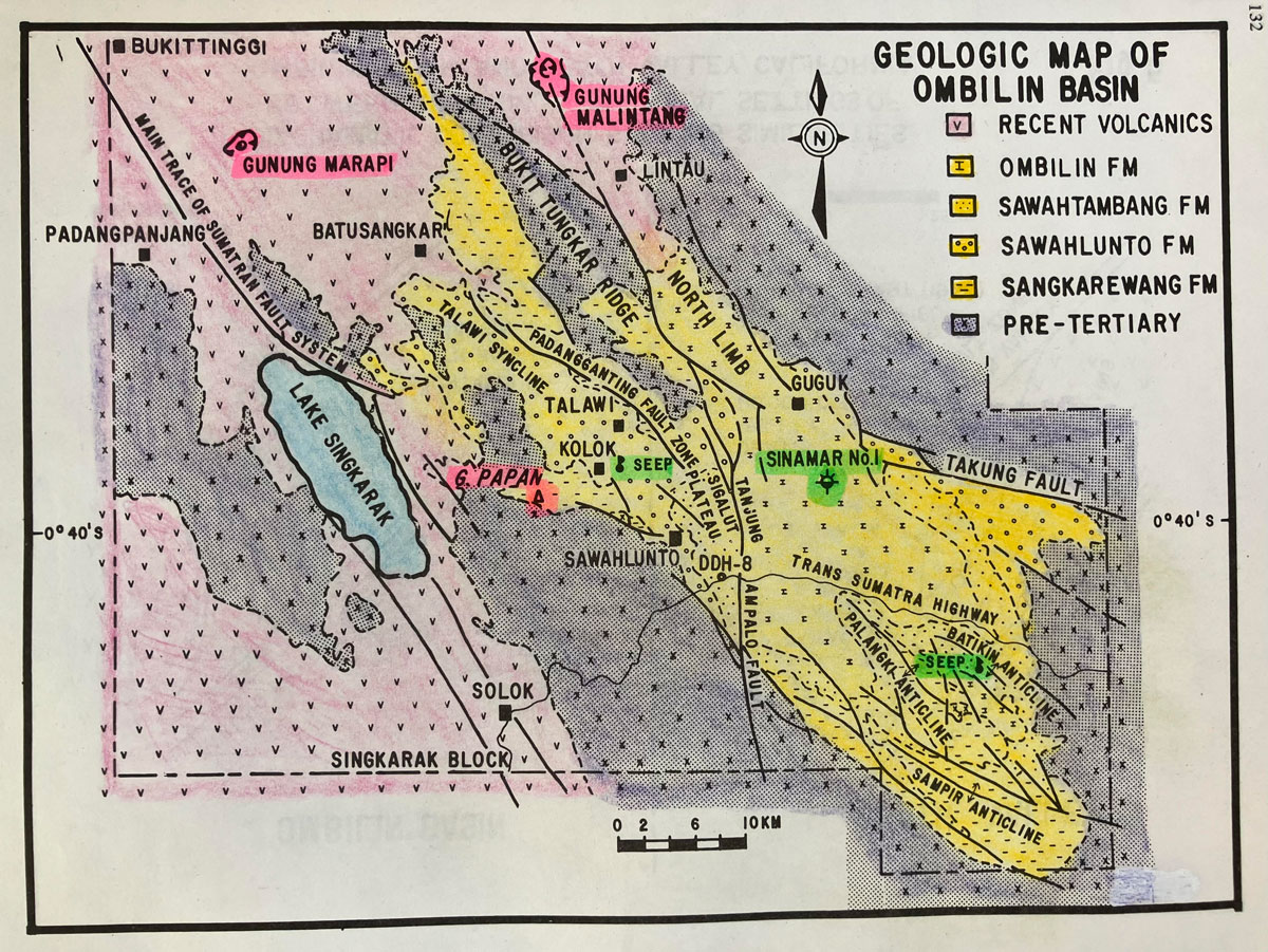
In 1980, Pertamina, Indonesia’s state oil company, announced that a block in the province of West Sumatra would be made available for competitive bidding. Called the Singkarak Block, it included the Ombilin Basin, a relatively small, 1,500-square-kilometer intermontane basin, 30-kilometers wide and 50-kilometers long, which had never been subject to oil exploration. The closest oil production was the Caltex-operated Langgak field located 120 kilometers northeast. This basin hosted the government-operated Sawahlunto coal mines, the largest in Indonesia, which since 1892 had been producing coal from Eocene-Oligocene rift-fill deposits.
The production-sharing contract was standard at that time for Indonesia. It stipulated that after cost recovery, the Indonesian government would own 85 percent of the oil discovered, 70 percent of the natural gas and the remainder went to the contractor. The contractor had to pay corporate taxes, taxes on interest and dividends and royalties to the Indonesian government.
I was leader of the exploration team charged with the evaluation. We had little information on the basin, which was outlined by colonial-era surface geological maps and some large-scale maps published by the Geological Survey of Indonesia. The team also used stratigraphic information from a few deep coal-core holes. No seismic had ever been recorded to reveal the depth of the basin or show if any structural closures existed in its deeper parts.
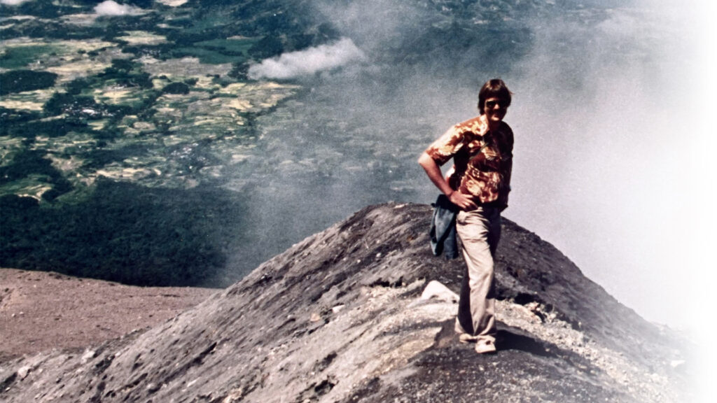
What also made this basin very unusual for oil exploration was that it was located on Indonesia’s magmatic arc, the so called “Ring of Fire.” Indonesia has 127 active volcanoes, of which seven are in Sumatra. Three active volcanoes were in the Singkarak Block including Mount Marapi with a height of 2,891 meters. It is the most active volcano in Sumatra and is known for frequent violent eruptions, often accompanied by pyroclastic flows and lahars. We were aware that in 1979 an eruption had caused 60 people to lose their lives.
Mount Marapi is on the northwest end of the Ombilin Basin, 35 kilometers away from where we would eventually drill our first exploration well. We worried that perhaps the volcanos had “burned off” any oil or gas that might have accumulated at one time in the basin. The team was also worried that heat from the volcanoes might have “overcooked” any potential oil source rocks. We were also concerned that the basin was in a tectonically active area, just east of the Great Sumatra Fault Zone where destructive earthquakes occur frequently. Perhaps all of that tectonism might have caused breaching of any seals associated with structural traps.
The principal encouragement in the basin came from two oil seeps located along its southern and western margins. These seeps implied that oil source rocks were present somewhere in the basin and had been subjected to temperatures sufficiently high to generate oil. Despite all of the risk, we submitted a bid to Pertamina which included a seismic program and the commitment to drill an exploration well. In 1981, Caltex was awarded the block and very soon exploration began.
Evaluating the Basin
The Ombilin Basin varies from rugged, jungle-covered mountain highlands to intensively cultivated rice paddy-terraced lowlands. A field mapping team was organized consisting of Nick Cameron and John Aspden of the Institute of Geological Sciences of Keyworth, England. Both Nick and John had extensive prior work experience in Indonesia and were hired as consultants. Several undergraduate students from the Institute of Technology Bandung served as field mapping assistants. Field work was challenging due to extensive rain forest along the edges of the basin which obscured the underlying geology. Helicopter support helped to access the more inaccessible parts of the basin. Critically important outcrops could only be found down in deep-stream cuts, which subjected the geologists to the tropical heat and humidity, bugs, snakes and various other critters.
None of this slowed down Nick or John – the information they gathered was simply invaluable. From time to time, I joined them in the field. The mapping provided a wealth of new geological information that guided subsequent exploration.
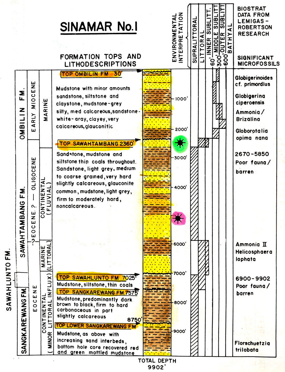
The field work identified a thick sequence of sandstones called the Sawahtambang Formation, which we predicted to be the primary reservoir section. Based on palynology, these were dated as Eocene – Oligocene. Overlying it was the Early Miocene-age Ombilin Formation, a marine shale that we viewed as the basin’s cap rock. Overlying the Pre-Tertiary basement are organic-rich lacustrine shales of the Eocene-age Sankarewang Formation. We believed that these shales were the primary oil and gas source rock in the Ombilin Basin. These shales likely generated the oil found in the two oil seeps.
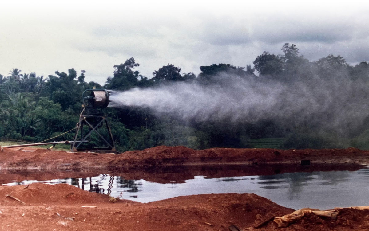
The exploration program included a synthetic aperture radar airborne survey, a basin-wide gravity survey and 660 kilometers of 24-fold seismic data. Rice paddies covered most of the lower-level areas. Since the local population maintains the traditional Minangkabau culture, introduction of a high technology seismic operation into this area required patience, tactfulness and understanding of the local culture to ensure cooperation of the population. To overcome socio-cultural problems and benefit the local economy, 90 percent of the 800-man seismic crew consisted of West Sumatrans.
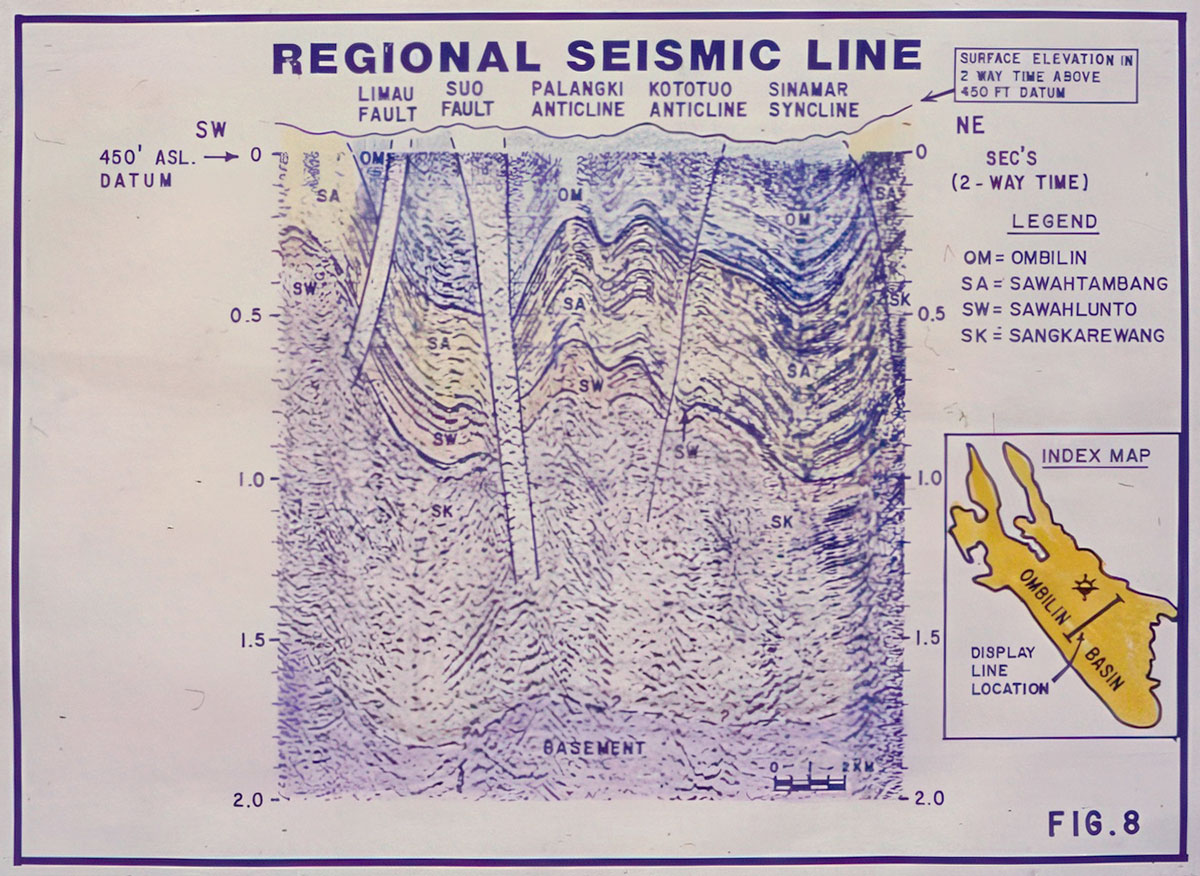
When we submitted our bid to Pertamina, we could see a large surface structure called the Palangki Anticline on one of the government surface geology maps. We had postulated that perhaps Palangki could hold 500 million barrels of oil and had planned to drill our first exploration well there. However, to our dismay, mapping by Nick and John revealed that the core of the anticline was exposed at the surface and consisted of tight basement andesites. So that eliminated Palangki.
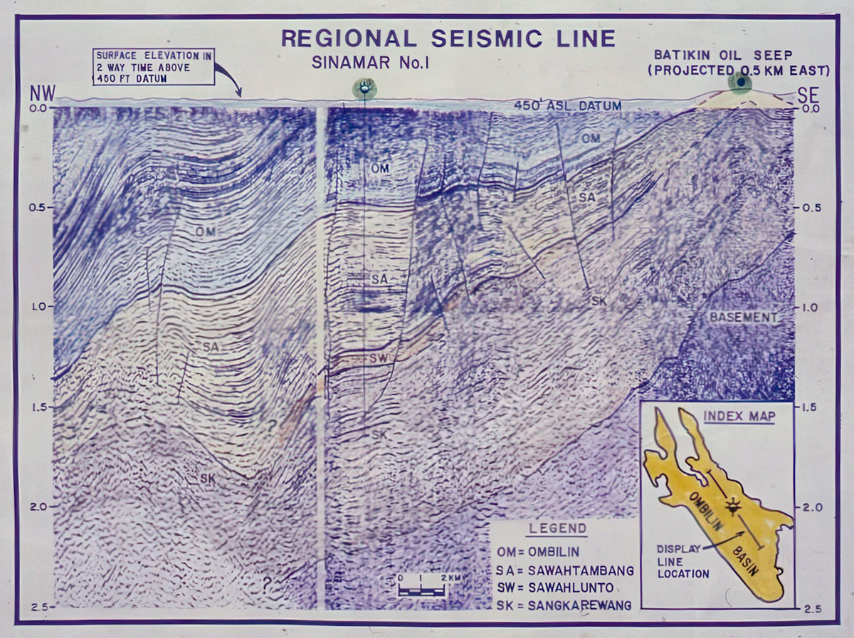
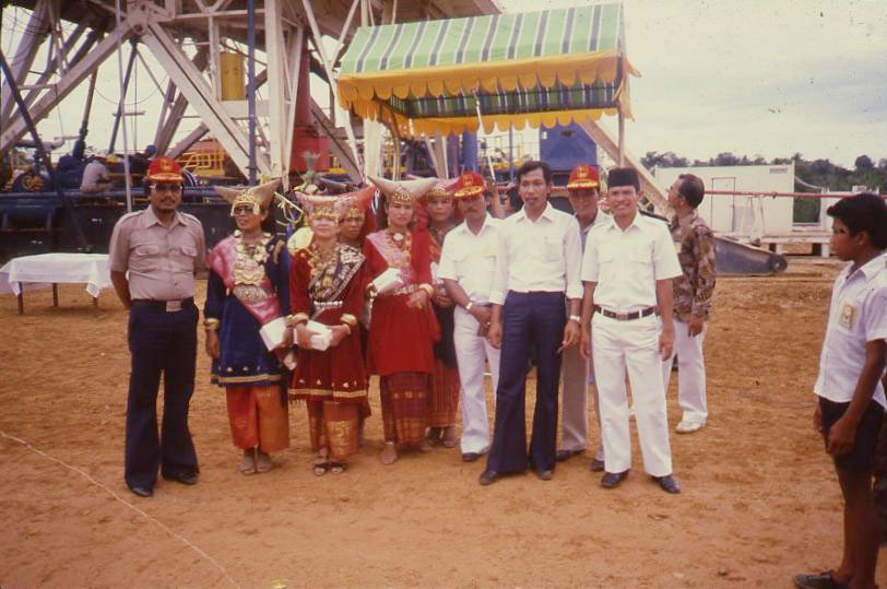
It also caused a lot of anxiety about the remaining potential of the basin. Being the team leader, I was faced with the unenviable task of informing Caltex, Texaco, Chevron and Pertamina executive management that the basin’s primary prospect had wiped out. Very fortunately, the subsequent seismic proved to be of amazingly high quality and showed that the basin contained at least 4,575 meters of sediments. The seismic also revealed an attractive closure in the middle of the basin which became the target of the Sinamar-1 exploration well that spudded on Nov. 22, 1983.
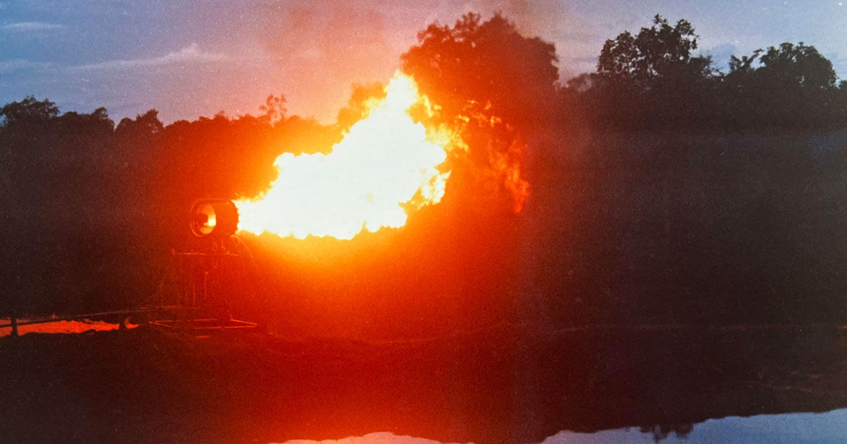
Since Sinamar-1 was a geologically high-risk exploration well and the first well ever to be drilled in the Ombilin Basin, we were amazed that it actually discovered oil and gas, albeit in non-commercial quantities. At the top of the sand-rich Sawahtambang Formation, we ran an open hole drill stem test over a large interval from about 670 to 800 meters. The well flowed oil at 22 barrels per day, 36-degrees API, 95-degrees-Fahrenheit pourpoint (a high wax crude), gas at 2.85 million cubic feet per day (70-percent CO2), and 88 barrels of water per day. Another zone in the Middle Sawahtambang, at a depth of 1,535 meters, tested 13.56 MMCFD, 44.6-percent methane, 6.5-percent ethane, 8.9-percent pentane, 40-percent CO2 and 314 barrels per day of condensate, 56-degrees API. This flow was from a 3-meter perforated interval. The well reached a total depth of 3,020 meters and was plugged and abandoned.
Adding to the drama of this high-profile exploration well was a notable event. In November 1983, just as the well was about to spud, Houston-based Esso Exploration Inc announced that they had farmed into the Singkarak Block. They agreed to pay for all prior costs and the cost of Sinamar-1. Accordingly, all expenses in the Ombilin Basin, which amounted to approximately $30 million, were cost-free for Caltex. One year later the block was relinquished back to Pertamina.
Exploration in the Ombilin Basin after Caltex
In 1990, the Singkarak Block was renamed the Padang Panjang Block and made available by Pertamina for competitive bidding. Hunt International Petroleum Company became operator of the block in 1991 and subsequently farmed out 50 percent to Apache Oil Sumatra Inc. The only work done by these companies was to reprocess the seismic shot by Caltex. In 1994, Apache drilled South Sinamar-1, an appraisal well to Sinamar-1. It was 6.5 kilometers southeast of Sinamar-1. The well was drilled to a shallow depth of only 1,145 meters, just barely into the top of the Sawahtambang sand section. It encountered oil shows associated with mud gas peaks and was plugged and abandoned without testing. In my opinion, South Sinamar-1 was basically a “posthole” which should have been drilled much deeper to evaluate the much more prospective Middle Sawahtambang sediments. Since then, no other wells have been drilled in the basin. Accordingly, the Ombilin Basin can be viewed as minimally explored for oil and gas.
In 2008, the block was renamed the Southwest Bukit Barisan Block and awarded to an Indonesian company called Radiant Bukit Barisan E&P. The government announced plans in 2021 to push industrial growth in West Sumatra in order to absorb gas from the Sinamar field. Tutuka Ariadji, who was the director general of oil and gas in the Ministry of Energy and Mineral Resources, stated that the Sinamar field’s reserves amounted to 245 billion standard cubic feet of gas with the potential for gas production of 35 million standard cubic feet per day and 800 barrels of condensate per day.
Mount Marapi continues to be dangerous. In 2003, an eruption of Marapi tragically claimed the lives of 24 climbers.
Teamwork
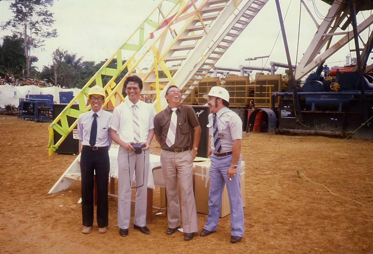
Exploration in the Ombilin Basin was truly a team effort. Caltex geologist Karsani Aulia and I integrated the surface geology information into the seismic lines and picked the location for Sinamar-1. The excellent quality seismic data was recorded by the geophysical team consisting of Bill Wycherley, Henry Schoellhorn, and “Pri” Supriadi. Executive management support was provided by Bachtoel Chatab, based in Caltex’s headquarters in New York and John Matush, vice president Far East-Middle East Exploration in Texaco’s head office in Harrison, New York. Management in Rumbai included Ted Jones, vice president of exploration; Suwahyuhadi Mertosono, exploration manager, and Roger Eubank, chief regional geologist. Chaidar Makki was the chief operations geologist. Al Karcher headed up the drilling team which drilled Sinamar-1 with no operational problems and within the $13 million budget.
In 1985, Karsani and I wrote a paper on the Ombilin Basin which we presented in Jakarta at the 14th annual convention of the Indonesia Petroleum Association. The paper was titled “The Petroleum Geology of the Ombilin Intermontane Basin, West Sumatra.” We were determined to get the geological and geophysical information from the Ombilin Basin into the public domain before it got lost in various company and ministry files. We packed our paper with as much possible information about the field work, seismic and drilling, so that it might still serve as an important reference for petroleum geologists and academics.
I thank Nick Cameron, now semi-retired and living in Chesham, UK, for his review of this article. A hand of appreciation is also extended to J.T. (Han) van Gorsel, former long-time Esso Indonesia geologist, now living in Houston, for his excellent comments on this story.