An interview with Monte Swan developer of the magma-metal series classification and 7-layered Earth model.
What is your name and your background?
My name is Monte Swan. I am a mineral and petroleum geologist/engineer with a BS degree in geological engineering from Michigan Technological University and a MS degree in geology from the University of Arizona.
Enercat Technology
From 2013-2020 I was Chief Scientist/Marketing Specialist for Enercat USA and Revelant. Currently I am the Science Advisor for the company that developed the Enercat Tool, Enercat Technology, Inc. The tool uses physics to drive physical changes in oil & gas systems. It eliminates the need for chemical, thermal or mechanical mitigation of asphaltenes, paraffin and scale deposited in oil wells by preventing their deposition.
My primary assignment through the years has been development of the science behind the Enercat Tool, specifically to discover how the tool works. This work led to the discovery that production problems are caused primarily by intermolecular forces, which the tool reduces, preventing production problems at the quantum scale. Currently Enercat Science is focused on paraffin prevention. If the tool is installed correctly in wells that are good candidates, prevention of paraffin production problems will be close to 100%. The tool causes the reduction of intermolecular London Dispersion forces between alkane molecules. We often see an increase in production averaging 30-40% due to this decrease in the intermolecular forces, in combination with a reduction in interfacial tension of the brine. The interfacial tension reduction has numerous other affects such as: causing aragonite to crystallize instead of calcite thus preventing scale, prevention of the flocculation and deposition of asphaltenes, breaking of emulsions, increased oil gravity, reduction of viscosity, decrease in injection pressures and even destruction of unicellular microbes.
MagmaChem Research Institute
I co-founded MagmaChem Research Institute in 1984 with Stan Keith and we built a client base of more than 100 mineral and petroleum companies, the US Geological Survey, and state surveys. Our research applied to exploration dramatically reduced risk . This led to our targeting of metal systems for mineral industry clients and the discovery of 20 mineral deposits on 3 continents of insitu copper-gold-silver valued at $102 billon in today’s metal prices (Figure1).

Figure 1: Copper-gold-silver discoveries the result of targeting of metal systems
for mineral industry clients by MagmaChem.
The discoveries were made as a result of 1.) Reduction of exploration risk for clients by screening mineral systems for economically favorable magma-metal series and 2.) Use of igneous rock and element dispersion patterns to vector to mineral drill targets including ore and sweet spots (Figure 2).
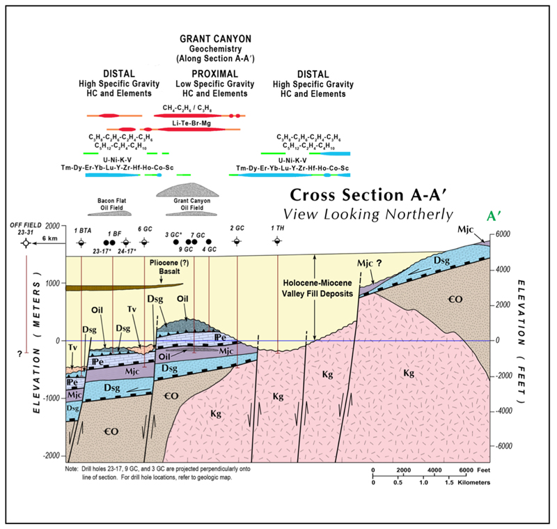
Figure 2: Grant Canyon oil field section based on drill holes and seismic interpretation showing correlation of oil fields with proximal hydrocarbon and multielement surface soil geochemistry.
Ultra-Deep Hydrothermal (UDH) Serpentinization and Petroleum Systems
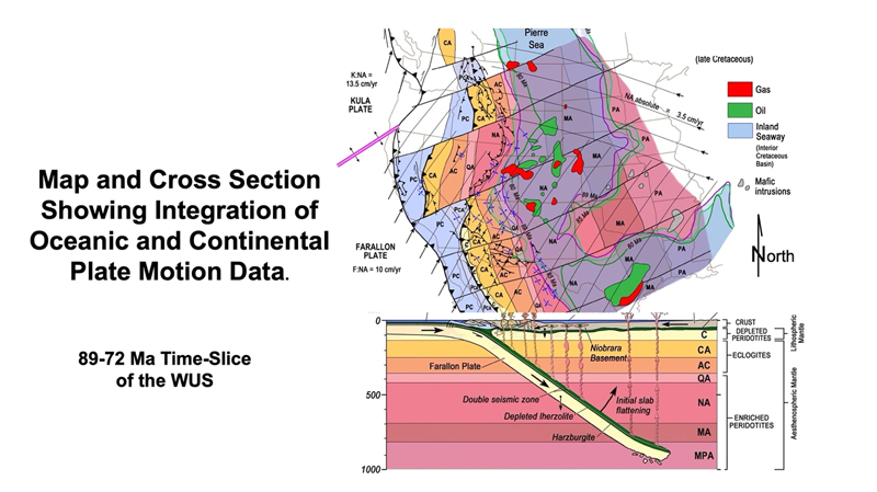
Figure 3: Map and crustal cross section showing the basis for dynamic basin modelling of oil & gas systems in light of plate tectonic integration of continental and oceanic plate motion data for the 89-72 paleotectonic time-slice of the WUS.
My petroleum research and exploration initially focusing on strato-tectonic analysis and dynamic basin modeling from a MagmaChem perspective (Figures 3 and 4).
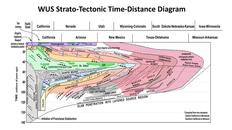
Figure 4: Strato-tectonic time-distance diagram for the panel of crust above the Garlock/Gila River oceanic slab segment from California to the mid-continent .
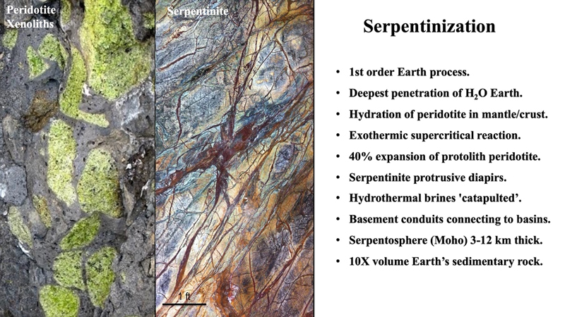
Figure 5: Examples of peridotite xenoliths
But it wasn't until 2001, after I presented a paper at the AAPG convention in Denver, that we began to look seriously at the sources, migration, and deposition of petroleum systems. Exxon Research told me they had come to this conference to find the answer to one question i.e., "When we do the accounting for supergiant giant oil & gas accumulations the books don't balance. Do you have any idea what we are missing?" They went on to ask, "Why are there metals in oil that seem foreign to oil and where does all the Mg come from for dolomitization?" And said, "Source rocks don't appear to have enough HC to explain the size of super giant oil & gas accumulations and that they had unanswered geodynamics (plate tectonic) questions." Several years later MagmaChem, now MagmaChem Research Institute, discovered a promising answer to the research group's questions: the overlooked Ultra-Deep Hydrothermal (UDH) process of serpentinization, which is the hydration of the igneous rock peridotite under supercritical conditions (Figure 5 and 6).
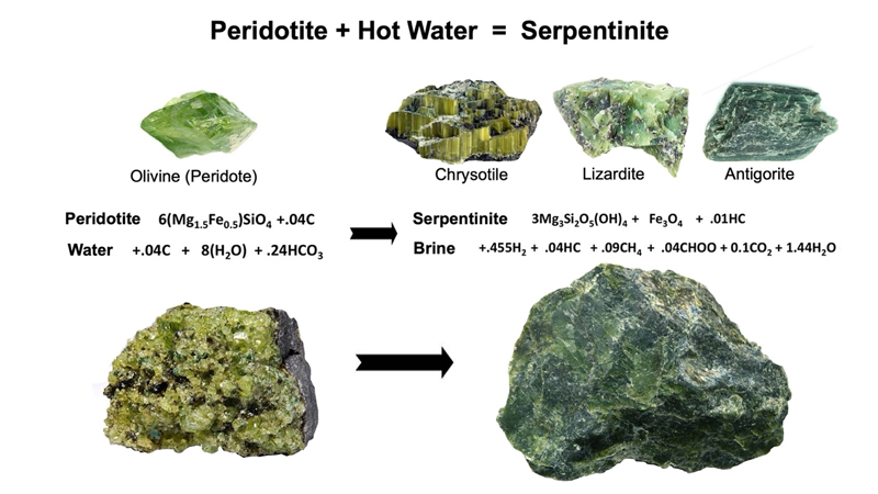
Figure 6: Hydration of peridotite to Serpentinite.
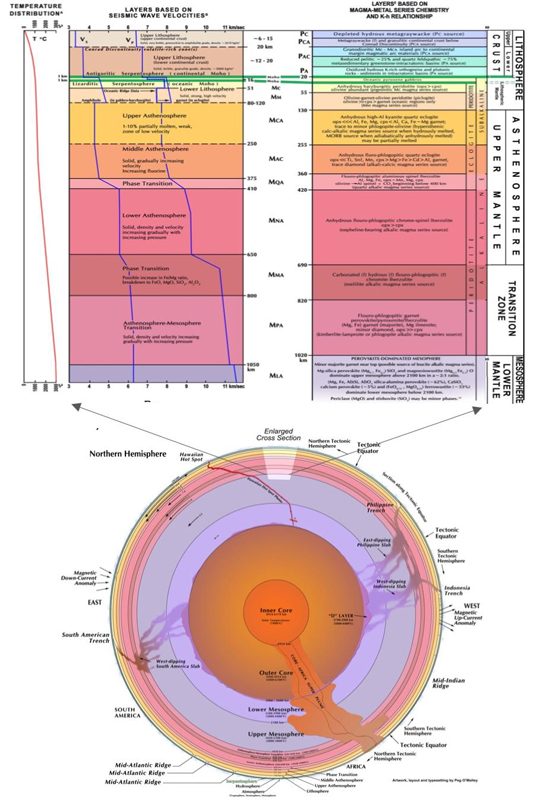
Figure 7: Magma-Metal Series Petrotectonic Model for a Layered Earth showing the chemically distinct and physically immiscible 8 layers of the asthenosphere and transition zone of the mantle.
MagmaChem Technologies
The result of MagmaChem’s work is an ‘image’ of the Earth analogous to an MRI image of the human body, which revolutionized medical science’s ability to diagnose and treat disease. What the MRI did for our understanding of the human body, MagmaChem in a geologic sense has done for the Earth. High-resolution images of the Earth’s interior have revealed details that have helped us better understand the Earth’s composition and processes such as discovery of the 'Serpentosphere', a near Earth-wide layer/shell of rock dominated by serpentine group minerals, largely lazurite under ocean basins and antigorite formed beneath continents. The Serpentosphere coincides with the seismic and gravity transition from crustal to mantle material, known as the Moho (Figure 7 and 8, Swan and others, 2010).
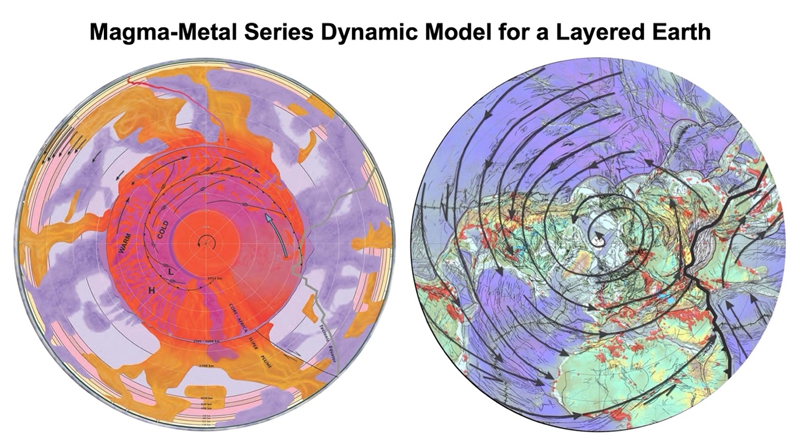
Figure 8: MagmaChem’s Dynamic Layered Earth Model provides a structural, compositional and process constrained reference frame for connecting deep Earth processes with shallow Earth processes. The model is based on a rotating core convection experiment (Sumita and Olson, 1999); the seismic tomography structure of the mantle (Grand, et.al 1997); MagmaChem’s Layered Asthenospheric and Lithospheric Mantle Model (Swan et.al., 2010); and MagmaChem’s Cracks of the World Map based on world-wide BHP magnetic/gravity maps (Keith et.al., 2003), showing spiraling fracture/fault zones, a potion of the tectonic equator and oil & gas systems in red.
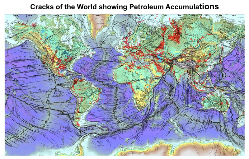
Figure 9: MagmaChem’s Cracks of the World Map based on world-wide BHP's magnetic/gravity maps (Keith et.al., 2003), showing the tectonic equator and oil & gas systems in red
Expansion of our view of the Earth beyond its surface in this way results in transformational applications to human health and climate, and possibly to our understanding of the origin and differentiation of life. We will also be better equipped to manage the Earth’s resources, address environmental challenges, and ultimately enhance our quality of life.
What have your research interests been over the years?
They began in the field (boots on the ground) with Kennecott's Geological Research Group determining the basement structural control of porphyry copper deposits in the SWUS. This led to the recognition of the 1.3-1.4 Ga Mesoproterozoic Orogeny and the origin of the WNW-trending faults of the Texas Zone. This orogeny was formally named 38 years later by Daniel, C.G., and others (2013) as the Picuris Orogeny. Continued research led to the idea that the Earth is circumvented by a necklace of generally latitude-parallel oceanic fracture zones and faults such as the WNW-trending faults of the Texas Zone and Mexico. The driving force for th etranscurrent motions on generally latitude-parallel faluts and fracture is the Earth's rotation around its axis. Much of Earth's resource endowment has been emplaced into these structures. Continued movement through geologic time could be considered 'background' strain--simply lateral strain along the faults, fractures and crustal weak zones causing low-pressure structures to form providing conduits for hydrothermal fluids.
From there I co-founded MagmaChem, now MagmaChem Research Institute, and worked on the development of the Magma-Metal Series Chemical Classification of Igneous Rocks and Mineral Deposits. This laid the foundation for recognition of the MagmaChem's dynamic 7-layered Earth model and the integration of oceanic data with continental data. The 7-layers have served as a reference frame through geologic time. They have brought predictive power to plate tectonics, dramatically lowering risk in the evaluation, discovery, and delineation of resource deposits.
Below is a partial list of research topics that flowed out of MagmaChem's magma-metal series classification and layered Earth model:
- Gold and Silver Expert System Advisor Software and Prospect Screen.
- Alteration Geochemical Variation Diagram Software.
- Igneous Rock Geochemical Variation Diagram Software.
- Element Dispersion Cluster and Assemblage Analysis Discriminator Software System.
- Element Vectoring and Assemblage Mapping Software System.
- Strato-Tectonic Analysis, Time-Distance Diagrams, and Paleo-Tectonic Time-Slice Maps.
- Crustal Oxidation State Contour Maps correlating with Metals, Petroleum, and the Basement.
- Identification of Chemical Facies of Magmatic Arcs.
- Mapping Oceanic Slab Segmentation and their Geologic Assemblages.
- Kinematic Analysis, Fluid Fractionation, and Fluid Migration Mapping.
- Oxidation State, Magma Differentiation, and Magnetics used to Map Fractionation Paths.
- Staged Liquid/Liquid Fractionation of Magma-Metal Series.
- Global Metal Endowment and Economic Characteristics of Magma Series Grades/Tons.
- Magma-Metal Series Model book..
- Mineral System (Mineral Districts) Geologic Map Units.
- Ultra-Deep Hydrothermal Model (UDH).
- Recognition of 'Hydrothermalite'--the 4th Rock Type.
- Re/Os as a Petroleum System Vectoring and UDH Radiogenic Dating Tool.
- Mapping Basement Lithology by Superimposing (Fusing) Gravity and Magnetic Data.
- Identification of Serpentinization and Steatization as 1st-Order Geologic Processes.
What are you working on now?
Introducing the Enercat Technology to the oil & gas industry. I have worked primarily on the science behind the Enercat Tool which has now been generally accepted by oil & gas producers. Since the Enercat is a unique and entirely new disruptive innovation this has been a challenge. But recent installations have had spectacular results, particularly in the prevention of paraffin. At the same time we are often seeing increases in production. I am currently writing papers and presenting at conferences with my colleague Brian Clemishire and engineers and engineers of clients.
I am also continuing UltraDeep Hydrothermal (UDH) serpentinization research with the MagmaChem Research Institute team and our Norwegian associates, who were formerly with Statoil's New Idea's Group (now Equinor). We are planning a UDH meeting this summer. My specific interest is in writing a sequel to our Cracks of the World paper (Figure 9 and Keith and others, 2003). In that paper we proposed that resources are often tied to transcurrent motions on the generally latitude-parallel faults. My work, particularly in Mexico suggests that 'hydrous' or 'wet' faults may be the key to why certain faults are tied to mineral deposits and oil & gas accumulations and others are not (Figure 10).
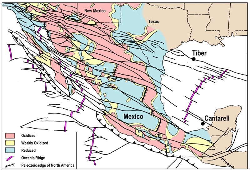
Figure 10: Map of hydrous basement faults of Mexico and oceanic transform faults and fracture zones of the Pacific and the Gulfs of California and Mexico based on chemistry and age dates of igneous rocks, 3000 mineral systems, crustal oxidation state, and the Paleozoic edge of North America,
Mineral systems emplaced along the wet faults in Mexico have 10 times the geographic area than mineral systems between the faults and are characterized by hydrous mineral whereas the dryer mineral systems are not.
Lastly, I am leading a GSA field trip this fall to the Dawson peraluminous gold deposit south of Canon City, Colorado. Peraluminous gold deposits are genetically associated with peraluminous magmatism that forms at the top of flat subduction zones as they sweep sodic mélange wedge graywacke under continents. Anatectic partial melting of these sediments produces peraluminous magmas that rise and migrated into weakly oxidized to reduced crust during advanced, strong compression due to the flat subduction. Peraluminous gold deposits span a spectrum that includes the world's largest gold deposit--Muruntau, Uzbekistan, containing 170 million ounces of gold. These deposits have been overlooked because peraluminous magmas contain >10 vol% water causing them to crystallize > 8 km depth at metamorphic grades of upper greenschist to amphibolite facies. In addition, ductile to brittle deformation occurs during emplacement. Thus they blend in with the metamorphic wall rocks. Many of these deposits are finally being discovered worldwide and are described as 'Orogenic' gold deposits.
Please discuss your view on new development on geothermal/hydrothermal regions of the earth - in current times and in geological history.
The Magma-Metal Series Classification of Igneous Rocks and Mineral Deposits classifies geothermal systemsboth geologically and economically. It also describes and predicts the nature of the hydrothermalism associated with each of the 6 plate tectonic settings through geologic time and how melting of the mantle and crust and serpentinization produces the hydrothermal fluids.
There are 2 major types of magmatism: metaluminous magmas sourced in the mantle and peraluminous magmas sourced in the crust. Although peraluminous magmatism contains more than twice the water contained in metaluminous magmas they do not have near surface geothermal potential since they crystallize at depths > 8 km. Metaluminous magmas do have geothermal potential and there are 2 types: anhydrous and hydrous. Anhydrous metaluminous magmas generated by rifting and hot spots are 'hot' and produce geothermal systems with high economic potential. They heat meteoric water or sea water producing hot water and steam low in volatiles, metals and minerals, because these magmas do not contain enough water to carry minerals themselves and have primarily a gas phase. Hydrous metaluminous magmas on the other hand are generated by moderate to steep subduction. Although these magmas have more thermal mass than than anhydrous magmas, they are cooler and their water is rich in volatiles, metal and minerals causing serious scale deposits. Thus they are less favorable economically than anhydrous magmas.
A magma's alkalinity ties anhydrous and hydrous magmas to specific mantle layers. This predicts the chemistry of the magma. In the anhydrous case it will determine the mineralogy of the magma and composition of its gas phase. In the hydrous case, it will determine not only the mineral composition of the magma, but the volatile, metal and mineral composition of the water released from the magma making a mineral deposit.
There are 2 main types of water in the basement--fresh and brine. Fresh water is produced as metamorphic formational fluids are released during transitions from lower to higher metamorphic grades. The hydrostatic pressure of the fresh water expelled during rising metamorphism opens wedge fractures.
Hydrostatic pressure increases faster than lithostatic pressure as you descend into the Earth. When the hydrostatic pressure overcomes the lithostatic load the fractures open. They have nearly infinite pressure at their tips and 'wiggle' their way toward low pressure which is typically associated with lateral strain zones along basement faults which contribute to the formation of 'wet' (hydrous) fault zones.
Brines are produced during serpentinization and released due to hydrothermal overpressure caused by the 40% expansion of peridotite when it is serpentinized. Serpentinization is an exothermic reaction causing the serpentinite brines to be hydrothermal. As they rise they crystallized into chemical muds including dolomite mud which can be injected into a sedimentary section, oil & gas reservoir and/or extruded on the sea floor, lake bottom or subaerially as chemical dolomitic mud extrudites or mud volcanoes. This dolomite often deposits with shales since shales are typically on the same timeline as underlying HTD. Dolomitic mud mounds and their hydrothermal seepage are often the heat and nutrient source for organisms that form bioherms. Temperatures beneath the bioherms can be as high as 325°C. Oil field brines have the potential to generate geothermal power particularly with small geothermal generators. Additionally, new technology is making it potentially economic to extract lithium from oil field brines.
We discovered the Lightening Dock geothermal field in New Mexico. It is a Basin and Range anhydrous metaluminous system that is economically favorable. Using soil geochemistry and a kinematic analysis we were able to vector to drill targets in the same way we vector to mineral deposit and oil & gas drill targets. The vectoring identified fractures and faults and which ones were active conduit for hot water in addition to mapping fluid flow and possible reservoir geometries (Figure 11).
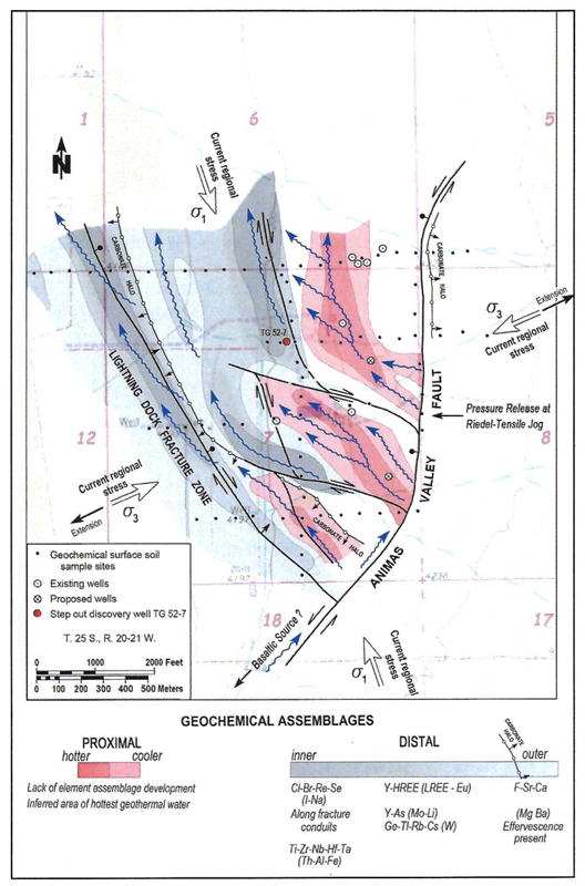
Figure 11: Lightening Dock Geothermal Resource Area New Mexico fluid flow and fractionation model showing geochemical vectoring assemblages. Wavy arrows show direction of flow
I've also been thinking about developing a classification of oceanic and continental hydrothermal seeps base on our Magma-Metal Series Classification of Igneous Rocks and Mineral Deposits.
What do you think of Mississippi Valley type deposits?
Mississippi Valley-Type (MVT) deposits led us to serpentinization. Our first project following up the Exxon question was with the New York State Energy Development Authority (NYSERDA) and DOE. They hired us to determine why petroleum accumulations and Mississippi Valley-Type Pb-Zn deposits are both often related to hydrothermal dolomite (HTD). Not only are all MVT deposits associated with HTD but more than 50% of petroleum systems are with dolomite as a major component of unconventional shale plays. Shell told us the oil in HTD reservoirs 'arrived just in time' begging the question of a genetic relationship. We began the NYSERDA/DOE project by searching for the source of Mg-rich hydrothermal brines in the basement under limestones necessary to produce the extensive HTD. After extensive geolchemical (>1 million analyses), mineralogical and mass balance analysis, we concluded it to be the source of the hydrothermal Mg-rich brines necessary for HTD. It also answered not only the question Exxon asked concerning the source of Mg for dolomitization, but also their questions concerning the source of metals in oil and MVT deposits and their questions concerning source rocks and plate tectonic geodynamics. Dolomitization, especially HTD, has been one of the great unsolved mysteries in geology. Serpentinization solves this mystery.
Mississippi Valley Pb-Zn deposits are hosted in hydrothermal dolomite (HTD) which is a product of serpentinization. A number of other enigmatic mineral deposit types are also the product of serpentinization, such as: Homestake (serpentinized magnesian-series harzburgite peridotite) and MVT Pb-Zn, Central African Cu belt and Zechstein Salines-Kupferschiefer Cu-Ag Deposits (serpentinized quartz-alkalic lherzolite peridotite).
Any plans for the future?
As you can see from my answers to your questions, there are many directions I could go. A current priority is taking the Enercat Tool to the oil & gas industry since after 7 years of research I finally found a reasonable hypothesis for how it works. It eliminates the need to use chemicals and greatly reduces costly mitigation/downtime. It also often increases production and is environmentally friendly--a true contribution to the industry. I enjoy helping companies reduce risk in their exploration through MagmaChem's technology. I have been working with an investor for years screening his commodity stocks with great success and will continue that work. I want to help take MagmaChem Research Institute into the future, continuing both our mineral and oil & gas industry exploration research and application. My co-founder Stan Keith and our protégé Troy Tittlemier, developer of the Permian Basin Experience (PBE) podcast, are hoping to automate the MagmaChem technology. I also want to continue our Ultra-Deep Hydrothermal (UDH) serpentinization research with our Norwegian colleagues Hans Konrad Johnsen, Martin Hovland and Håkon Rueslåtten.
I attended an energy transition convention some years ago and was struck by the fact that nearly every presentation focused on solving a problem/conflict or meeting a challenge all ended with the same solution--innovation! I was also struck by the fact that there was not one presentation or discussion on the topic of innovation--how ironic.
References
- Daniel, C.G., Jones III, J.V., Andronicos, C.L., and Gray, M.B., Making the case for the Picuris orogeny: Evidence for a 1500 to 1400 Ma orogenic even in the southwestern United States: The Geological Society of America, Field Guide 33, 2013, pp. 205-227.
- Grand, S.P. and Van der Hilst, R.D., High resolution global tomography: a snapshot of convection in the Earth: Geological Society of America, 1997.
- Keith, S.B., Swan, M.M., Rasmussen, J., and Laux, D., May 15, 2006, Cracks of the World -Global Strike-Slip Fault System and Giant Resource Accumulations: Reprint of Keith and others, 2003, in Reservoir (Monthly Magazine of the Canadian Society of Petroleum Geologists), vol. 33, no. 5, pp. 49-53.
- Sumita, I., and Olson, P., A laboratory model for convection in Earth's core driven by a thermally heterogeneous mantle: Science 286(5444): pg.1547-1549, 1999.
- Swan, M.M., Keith, S.B., Hovland, M., Rueslaatten, H., Johnsen, H.K., and Page, N.J., The Serpentosphere: Jun 13-18 Goldschmidt 2010 Earth, Energy, and Environment 2010, Knoxville, TN.