Operating drones is about to get a lot easier, with the implementation of Part 107, of FAA regulations. With that change, and the low cost of entry, experts expect to see explosive growth in all aspects of drone usage. New uses will be limited only by the imagination. Welcome to an interview with Marc Johnson, an engineer with 15 years in the oil industry, who builds and deploys drones for many different commercial applications.
What is your name and your relationship to drones?
My name is Marc Johnson and I have spent 15 years in the Oil and Gas industry applying my passion for technology working with data acquisition, control systems and software. I love helping people with big problems to solve and take pride in delivering successful outcomes implementing technology.
I founded skynce, LLC a year ago in order to offer consulting services to organizations implementing Unmanned Aerial Systems (UAS/drones) into their businesses. Technology improvements resulting in better drones at lower prices have made UAS adoption practical for a number of commercial applications. I work with my customers to implement the programs and technologies needed to execute UAS missions. When we move into the part 107 regulatory regime skynce, LLC will begin offering our customers Remote Pilot in Command (RPIC) services for hire in addition to the technology consulting services we currently provide.
When and how did you get interested in drones?
I have always been excited by UAS technology, I possess a mechanical engineering and computer science background and I have a passion for a wide variety of fantastic machines.
A couple of years ago I saw a $50 drone in the store and couldn't refuse. I just couldn't believe that someone could build a flying machine for that price. I had a lot of fun with that little drone in its short life, and like many of the drones that would follow it became a casualty in the name of furthering the science.
Intrigued by first experience I started investigating and was thrilled to find like-minded enthusiasts who were building their own drones out of relatively inexpensive components in their garages. Being an engineer, I of course thought I could do better and within a week I had parts on order to build a drone for myself.
Over the next year I would build a number drones for a number of applications. What really got me excited was using them for mapping and 3D reconstruction applications and I built a number of prototypes in my garage capable of capturing the required data. I was lucky enough to have a friend with a similar passion for flying machines with a large pasture that over time would turn to a veritable graveyard of drones. We learned so much about the technology as we built, flew, crashed and repaired our flying machines.
About the time I was getting my mapping prototypes airborne DJI released the Phantom, and it really changed everything. You could buy a $1000 drone at WalMart that, when coupled with the right software, was able to create detailed maps and structural models. Its introduction has enabled a whole new class of user. Cost effective and easy to use, its introduction is as significant as the personal computer or the Ford Model T. (A good number of our readers (or their kids) probably already have one of these).
I found the inspiration to found skynce, LLC after an aspiring drone pilot came to me with a DJI Phantom 3 not quite sure what he could do with it. He had heard about my experiments with mapping and was eager to learn more, I was eager to test the new Phantom so we spent a couple of days together in which we experimented with his new toy. The imagery I will present in this interview was captured during our time collaborating and learning.
I founded skynce, LLC, to help individuals and businesses understand and implement UAS technology, with a focus on how to utilize the acquired data for mapping and 3D reconstruction purposes.
What is the regulatory environment like these days? Do you see any changes in the near future? If so, what will the impact be?
We are on the cusp of a significant change in regulations that is going to reduce a lot of barriers to entry that are currently in place to organizations seeking to implement UAS technology. Specifically at the end of August the FAA will be putting into effect the new part 107 regulations. These new regulations will lower the regulatory threshold to commercially operate drones while maintaining the importance of safety in operations. A new class of commercial users will begin employing UAS technology as a routine function of their jobs.
While I am excited about the forthcoming part 107 regulatory regime that will be in place at the end of this month in April of 2015 the FAA in the face of media sensationalism about the potential for misuse introduced the burdensome process for obtaining FAA 333 exemptions for commercial drone use.
Under the current regulatory regime companies seeking to fly UAS commercially have to get a FAA 333 exemption, and all but the best-funded startups can afford the lawyers to get one in put in place. Further the Pilot in Command of operations had to hold a sports pilot's license at a minimum to operate the UAS. Reducing the number of projects that could be completed in a commercially viable manner.
As we see part 107 introduced in September, a lot of the regulatory overhead will be reduced for commercial operators. Remote Pilots in Command will need to be certified under the new regime, but the requirement to carry a sports pilot's license will be dropped. With these lower barriers to entry we are going to see professionals in a variety of markets adopt drone usage as a part of their day to day jobs. Insurance adjusters, realtors, landscapers, architects and yes, even geologists, are going to be adopting this technology.
What are some of the areas of most dramatic growth in drone uses?
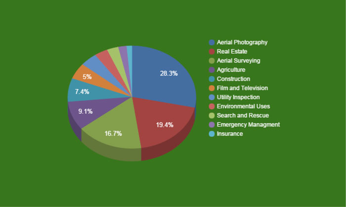
A breakdown of the first 1000 FAA 333 exemptions
If you look at the first 1000 333 Exemptions issued by the FAA you can get some insight into the early adopters looking to employ UAS as a part of their business. As we move to the new regulatory regime we are going to see increased usage in all these market segments.
Real Estate shows up pretty high on the list of exemptions granted, it will soon be the norm that 3D models like this will be included in real estate listings.
Aerial Surveying is also one of the most filed exemption types. Drones provide a means to capture up to date imagery of an area at a relatively low cost. Further this updated data can be easily imported into mapping applications.& When we look at lof of the activities associated with resource development and construction these are both areas where data currency matters.
The data collected for mapping applications can also be used to generate 3D models of terrain and other structures using a technique called photogrammetry. The resultant models can be used to complete tasks such as volumetric analysis and the generation of topographic maps.
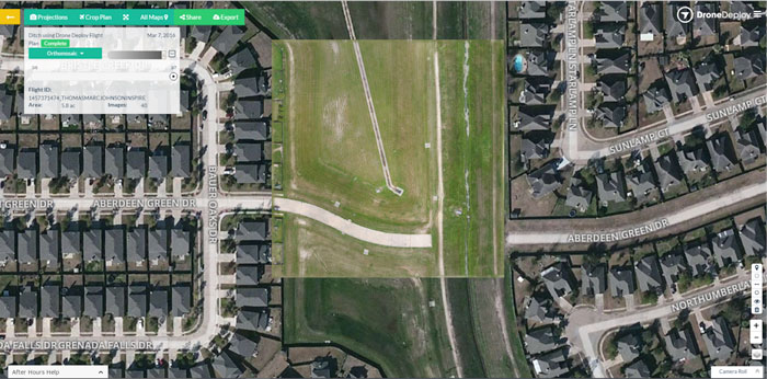
UAS acquired orthomosaic map overlaid on dated satellite imagery
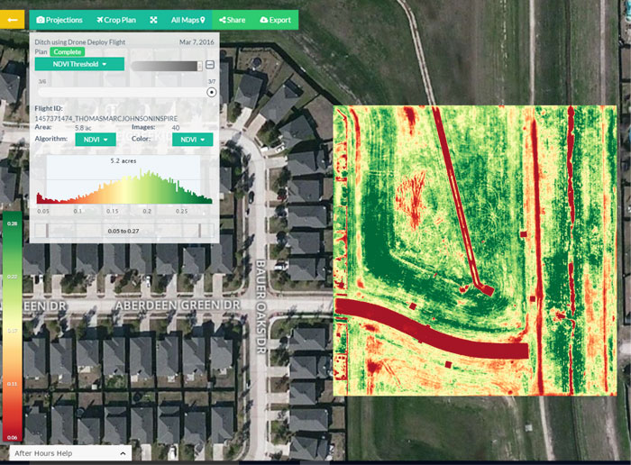
NDVI Map Generated from Drone Acquired data
Agriculture is another an area where we are already seeing widespread adoption of UAS, use of specialized cameras and Normalized Differential Vegetation Indexing (NDVI) is enabling farmers to really take a bird's eye view of their fields and identify areas that need remediation, prescribe corrective action and then monitor success of corrective actions taken.
How can an individual or a small business that focuses on natural resources development and geographical information get started? How best can they team up?
The first step is to really get educated about how drones can be used to support your business, and how the availability of current low cost aerial data will impact how you do business.
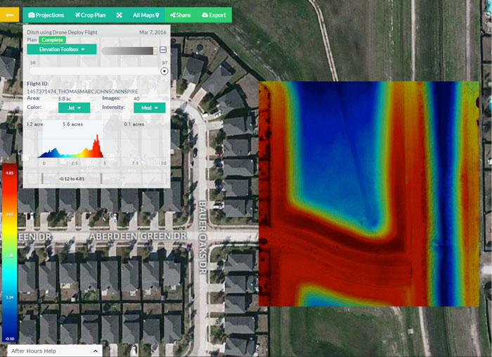
Topographic map generated from UAS acquired data
What you will find is that once you start exploring implementing this technology you will realize that finding a certified pilot and buying a drone is only a small piece of the drone adoption equation.
An organization needs to understand how it will plan, execute in compliance, process and ultimately use the data they acquire from drones. It needs to understand the investments in technology, training and compliance required to fulfil their vision.
I work with my clients to help them understand and implement the programs and technologies needed to achieve their vision of drone adoption in their business.
What kinds of drones are best to use and how much do they cost?
Earlier in this article I gave pretty high praise to DJI and there Phantom Drone, and all the imagery I have used in this article was captured using these devices that are extremely accessible given current pricing.
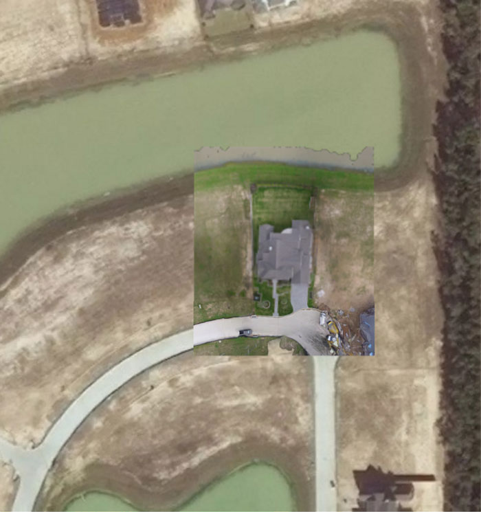
Drone acquired orthomosaic map overlaid on dated satellite imagery
With that said a Drone should be selected as a function of what you are trying to accomplish. The phantom is a great tool for surveying small areas of interest, for larger areas such as those encountered in agricultural applications fixed wing drones are often better suited for the job. There are a quite few options for commercial fixed wing drones available with mission specific payloads.
Further the cost of the drone is really only a small part of the investment required to leverage UAS technology in your business. Software, insurance, certification, location, size all factor into total operation cost. These things all need to be considered when planning a UAS operation.
What do you see as the best opportunities in the medium-term?
Once we move into the new regulatory regime in September we are going to see explosive growth in all the fields mentioned above. A lot of projects that were not cost effective suddenly will be, further there will be less regulatory overhead. For a lot of business the next few months will be a key time to adopt this technology to gain a competitive advantage or to just keep up.
Stay tuned: AAPG Workshop on How to Make Money with Drones in Houston, early December 2016