Deep freeze: Cutting-edge technology, environmental awareness and a lot of warm clothing are helping seismic crews cope in hostile Arctic regions.
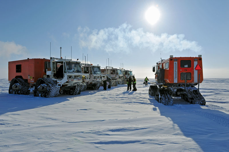
The big chill: Carefully monitored operations, specialized equipment and intensive training help seismic crews minimize impact in the harsh but delicate Arctic environment. Photo courtesy of CGGVeritas.
For seismic to unlock the potential of challenging exploration environments, we’ll need some key ideas.
That’s especially true in the Arctic, one of the most hostile settings on the planet.
There, a key concept known as turning ray tomography (TRT) is helping geophysicists deal with near-surface conditions that can include ice, permafrost, partial melt, running channels and gassy hydrate slush.
Seismic companies have learned to live with data acquisition in challenging situations.
“In fact, hardly any of them are easy,” said Scott Cheadle, who served as head of research and development in the Calgary, Canada, division of CGGVeritas.
Cheadle is now a technical consultant for the company and lives outside of Thunder Bay, Ontario – “on a good piece of property in a beautiful part of the world,” he said.
His experience with seismic acquired in the Arctic gives him a special perspective on the problems of hostile environments.
“It’s certainly a new era in terms of doing any sort of exploration or seismic acquisition in the northern parts of the world,” Cheadle noted.
Problems range from temperatures that can drop below minus 50 degrees F, to a short seasonal window for survey work, to sensitive habitats and other environmental restrictions.
“For instance, you can’t place seismic sources anywhere you want,” he said. “Some of these bodies of water are closely monitored. The wildlife is protected.”
A Challenging Environment
Cheadle worked on seismic imaging software for use with data acquired in the Arctic. Geophysicists have learned that determining near-surface velocities are important for structural imaging of deeper strata and reservoir characterization.
“In terms of land seismic, the Arctic near surface is extremely challenging,” he noted. “We rarely ever know enough about it.”
Traditional refraction analysis of the near-surface works best when simple layering of the shallow subsurface is present, apparent from the pattern of first arrivals on seismic records, Cheadle explained. Several different modes of seismic energy, including head waves, body waves following turning ray paths or noise may appear as a first arrival.
On any given dataset, some or all of these may be present.
“If you have clear linear segments punctuated by a sharp change in angles of those first arrivals, you likely have a situation where you have layering,” he said.
Analysis of the timing and slopes of the first arrivals indicate the velocity and thickness of the near-surface layers.
“If you have a more complicated near-surface or if you have a velocity inversion, they look more arbitrarily curved,” he noted.
“Permafrost is exactly the opposite to simple layering. It’s extremely patchy. It’s a high velocity material underlain by a low-velocity material, which is something seismic doesn’t want to see,” Cheadle added.
He compared some Arctic near-surface conditions to Swiss cheese due to localized melting, with varied states of material, mixed low- and high-velocity areas and unreliable, missing or compromised data.
“To make a model of the near surface, we assume we understand the nature of the first breaks,” Cheadle said. “If all you have is a linear first break at ice velocity you essentially have a situation where any meaningful information about the near-surface is lost.”
In working with Arctic seismic data, “it would not be unusual to spend weeks, literally man-months, picking the first breaks,” he said.
Because of the challenges involved, seismic can almost never accurately identify the bottom of the permafrost layer, according to Cheadle.
TRT helped CGGVeritas characterize and better understand the nature of the Arctic near-subsurface.
“CGGVeritas routinely runs generalized linear inversion (GLI) refraction analysis and our turning-ray tomography on every project, and assess which solution works best on a case-by-case basis,” Cheadle said.
Tomography is essentially imaging in sections or slices, using wave energy. TRT treats the near-surface media as a grid of small rectangles in which rays are turned or continuously refracted.
“It looks at things as a more complex grid model,” Cheadle said, “a requirement in areas affected by permafrost.”
Like all seismic tomography, TRT uses somewhat different assumptions from standard seismic interpretation. That gives it an edge in imaging when refractors are not layered.
Geophysics has found that TRT’s shallow velocity imaging can provide good short and long wavelength statics. And good long-wavelength statics can improve deep structural interpretations.
“We have peculiar ideas about seismic,” Cheadle noted. “We want to have perfect resolution from right below the geophone down to the target of interest.”
But imaging of exploration targets is the main point of a seismic survey, and TRT can help interpreters clear away the mist of the near-surface for a better view of the deep subsurface.
The Fifth Dimension
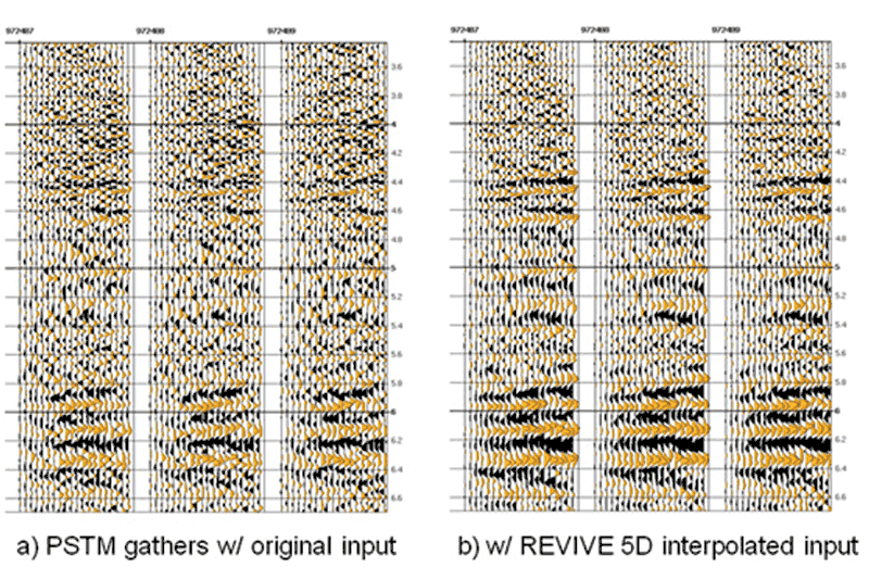
Graphics courtesy of CGGVeritas.
Environmental restrictions in the Arctic often leave areas where data can’t be collected.
Polar bear dens, sensitive natural features, lake areas and many other places are out-of-bounds to seismic crews.
“We’re always working with compromised data,” Cheadle said. “The bigger the holes – the more of these exclusions there are – the bigger the challenges.”
To address the problems of incomplete data acquisition and undersampling, CGGVeritas developed its “Revive 5D” interpolation approach, “to infill sampling gaps and increase spatial sampling while preserving original recorded data.”
This method performs simultaneous prestack interpolation in five dimensions –inline, crossline, offset, azimuth and frequency – to predict new sources and receivers at desired points.
According to the company, the interpolator algorithm is based on Fourier reconstruction.
Interpolation is posed as an inverse problem where the model is a super-sampled seismic data set that contains the desired target geometry. A sampling operator maps the model to the acquired data.
Interestingly, all five dimensions are considered simultaneously in Fourier space. That enables the interpolation method to incorporate amplitude variations due to both structure and stratigraphy.
“The advent of good interpolation is a happy marriage” between gaps in known data and today’s massive processing capabilities, Cheadle said.
Geology also can assist the geophysicist in characterizing the near-subsurface. The more facts available, the better.
“There’s virtually no place in the Arctic where it isn’t helpful to have some shallow logging,” Cheadle noted.
CGGVeritas has worked in the Arctic since 2001. Like other seismic companies, it’s learned to work within the restrictions of a challenging, environmentally sensitive area.
“We generally have to work pretty quickly. Every aspect of working in the Arctic is highly monitored. It’s not necessarily restrictive in the technical sense, but it is tightly controlled,” Cheadle said.
Because of the sensitive nature of the setting – seismic crews receive top-notch training in minimizing impact, from carefully planned and monitored operational procedures to utilizing specialized equipment.
Crews also come up against the challenges of working in an area that is remote, dehydrating, difficult, demanding and often dangerous.
Not to mention, really cold.
“Things don’t always work at 30 below,” Cheadle said. “They break a lot.”