Imagine a Google Earth image, but with much higher resolution and combined with analytics that make new relationships and surface information clear in ways that were never possible before. And, imagine this at a fraction of the cost you imagined. Welcome to an interview with Mark E. Romano, Harris Geospatial Corporation.
Imagine a Google Earth image, but with much higher resolution and combined with analytics that make new relationships and surface information clear in ways that were never possible before. And, imagine this at a fraction of the cost you imagined. Welcome to an interview with Mark E. Romano, Harris Geospatial Corporation.
What is your name and your relationship to aerial operations and remote sensing?
Mark E. Romano, Sr. Product Manager Harris Geospatial
Over 30 years of remote sensing experience in Hardware/Software development and services including: Airborne Linear LiDAR, GM LiDAR, EO, HSI, and other terrestrial platforms. Current role to develop and productize new geospatial capabilities, products and services.
What is Geiger-type LIDAR?
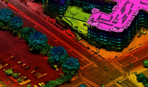
Geiger Mode (GM) LiDAR was developed over 17 years ago in support of U.S defense missions to address heavy foliage environments for surveillance applications on large scale wide area projects. Only a few years ago, key components were de-classified, allowing Harris to develop the first GM LiDAR system for commercial use. GM LiDAR is an active (laser) ranging time-of-flight system much like conventional (linear) LiDAR. However, it requires much less power since the receiver is photon sensitive. This allows the system to fly much higher and faster than conventional systems, (6,000-34,000) feet above terrain, producing high-resolution data with dramatically increased efficiency. In addition, since the receiver is an array (32 x 128 frame camera) rather than a single detector, it is not set up to collect at a single or "maximum" resolution like linear sensors. Instead, the scene is "oversampled" from multiple measurements (data frames) and angles (4 looks) where final resolution is developed through process rather than collected resolution. When creating GM LiDAR point clouds, data are processed in voxel space from multiple samples and look angles, which creates an aggregated, highly uniform data distribution with less occlusions (shadows) often experienced from conventional systems. What this means to the end user is that multiple resolutions can be processed from the same data with higher detail and quality for a variety of applications. When data are collected at equivalent or even higher altitudes, GM LiDAR will dramatically outperform conventional systems.
What kinds of images can it produce?
What are some of its unique capabilities?
- Fastest wide area collection of high resolution 3D data
- Superior foliage penetration at equivalent or higher altitudes
- More uniform data distribution through unique process
- Less data occlusion in foliage and around buildings and other manmade features
Can you give a few examples of how it is being used today?
GM LiDAR has been used for a variety of projects over the past two+ years including: topographic mapping; floodplain mapping; forestry analysis for harvest planning via discrete species characterization and harvest yield analysis; utilities projects including mapping of transmission and distribution wires and poles, vegetation-danger-tree assessment and asset management; urban planning, oil and gas field development; and others.
What do you project for the future?
GM LiDAR will continue to evolve with larger sensor arrays and higher performance characteristics. The GM APD camera of today will improve like all digital cameras as they are produced at higher quantities and foundries improve processes. This fact alone will increase both efficiency and provide a path to new applications in both airborne and terrestrial applications (think UAVs, autonomous vehicle's, etc.) For airborne applications, lighter weight, smaller form factor, and lower power systems will emerge making today's linear technology obsolete at some point in the future.